206.130.240.240 - IP Lookup: Free IP Address Lookup, Postal Code Lookup, IP Location Lookup, IP ASN, Public IP
Country:
Region:
City:
Location:
Time Zone:
Postal Code:
IP information under different IP Channel
ip-api
Country
Region
City
ASN
Time Zone
ISP
Blacklist
Proxy
Latitude
Longitude
Postal
Route
Luminati
Country
ASN
Time Zone
America/Toronto
ISP
COLOSSEUM-ONL
Latitude
Longitude
Postal
IPinfo
Country
Region
City
ASN
Time Zone
ISP
Blacklist
Proxy
Latitude
Longitude
Postal
Route
IP2Location
206.130.240.240Country
Region
ontario
City
toronto
Time Zone
America/Toronto
ISP
Language
User-Agent
Latitude
Longitude
Postal
db-ip
Country
Region
City
ASN
Time Zone
ISP
Blacklist
Proxy
Latitude
Longitude
Postal
Route
ipdata
Country
Region
City
ASN
Time Zone
ISP
Blacklist
Proxy
Latitude
Longitude
Postal
Route
Popular places and events near this IP address

Lansdowne station (Toronto)
Toronto subway station
Distance: Approx. 438 meters
Latitude and longitude: 43.65916667,-79.44277778
Lansdowne is a subway station on Line 2 Bloor–Danforth of the Toronto subway in Toronto, Ontario, Canada. The main station entrance is located just north of Bloor Street on Lansdowne Avenue, with a secondary unstaffed entrance on Emerson Avenue. Opened in 1966, the station lies approximately 561 metres (1,842 feet) from its nearest station to the west, Dundas West.

Dufferin station
Toronto subway station
Distance: Approx. 270 meters
Latitude and longitude: 43.66,-79.43555556
Dufferin is a subway station on Line 2 Bloor–Danforth of the Toronto subway in Toronto, Ontario, Canada. It is located at Dufferin Street just north of Bloor Street West. It opened in 1966 as part of the original segment of the subway line.

Bloordale Village
Human settlement in Ontario, Canada
Distance: Approx. 273 meters
Latitude and longitude: 43.659,-79.439
Bloordale Village is a Business Improvement Area (BIA) located along Bloor Street from Dufferin Street to Lansdowne Avenue, west of downtown in Toronto, Ontario, Canada. It sits on the southern border of the Wallace Emerson neighbourhood and the northern border of the Brockton Village neighbourhood. The district is home to various and unique shops including restaurants, bars, vintage and thrift stores.

Bloor Collegiate Institute
High school in Toronto, Ontario, Canada
Distance: Approx. 257 meters
Latitude and longitude: 43.659292,-79.436994
Bloor Collegiate Institute is a public secondary school in Toronto, Ontario, Canada. It is located at the intersection of Bloor Street and Dufferin Street, in the Dufferin Grove neighbourhood. The school was originally part of the Toronto Board of Education that was merged into the Toronto District School Board.

Wallace Emerson
Neighbourhood in Toronto, Ontario, Canada
Distance: Approx. 281 meters
Latitude and longitude: 43.663,-79.441
Wallace Emerson is a neighbourhood in Toronto, Ontario, Canada situated north of Bloor Street between Dufferin Street to the east, the CPR railway lines to the north and the CPR railway lines to the west. The neighbourhood derives its name from the intersection of Wallace Avenue and Emerson Avenue near the centre of the community.

Bloor/Gladstone Library
Library in Toronto, Canada
Distance: Approx. 383 meters
Latitude and longitude: 43.659913,-79.434017
The Bloor/Gladstone Library is a branch of Toronto Public Library, located at 1101 Bloor Street West, Toronto, Ontario.

The Monkey's Paw (bookstore)
Distance: Approx. 467 meters
Latitude and longitude: 43.6603,-79.4327
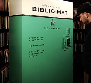
The Monkey's Paw is an independent used bookstore in Toronto, Ontario, Canada known for its eclectic, arcane, and absurd books, and for the Biblio-Mat, a random book vending machine. Owner Stephen Fowler founded The Monkey's Paw in 2006, four years after he moved to Toronto from San Francisco, where he worked in numerous bookstores. Fowler opened The Monkey's Paw in order to support his family with another income source.
Brockton High School (Toronto)
Public high school in Toronto, Ontario, Canada
Distance: Approx. 365 meters
Latitude and longitude: 43.658129,-79.437958
Brockton High School (also known as Brockton HS, BHS, or simply known as Brockton) was a Toronto District School Board learning complex based in the Brockton Village neighbourhood of Toronto, Ontario, Canada that once operated as Brockton Learning Centre consisting of the Aboriginal Education Centre and the Caring and Safe Schools Brockton program. It was formerly a public and vocational high school operated from 1967 to 1995 by the Toronto Board of Education. The Brockton property, located near Dufferin Mall, is still owned by the Toronto District School Board, and the lot is under construction to be the future Bloor Collegiate Institute.
German International School Toronto
Distance: Approx. 350 meters
Latitude and longitude: 43.659,-79.4355
The German International School Toronto (GIST, German: Deutsche Internationale Schule Toronto) is a German private school in Toronto, Ontario. The school offers grades from Pre-Kindergarten through Grade 10 and will offer up to grade 12 by the 2025-26 school year. GIST is an IB World School, offering the Bilingual IB Diploma in German.

Paradise Theatre (Toronto)
Cinema in Ontario, Canada
Distance: Approx. 618 meters
Latitude and longitude: 43.661028,-79.430649
The Paradise Theatre is a movie theatre located at 1006 Bloor Street West in the Bloorcourt Village neighbourhood of Toronto, Ontario, Canada. It first opened in 1937, closed in 2006, and then was to be turned into a pharmacy. However, it was restored and re-opened on December 5, 2019.
Bloordale Beach
Guerilla art installation and community hub
Distance: Approx. 365 meters
Latitude and longitude: 43.658129,-79.437958
Bloordale Beach was an informal community hub in the west end of Toronto, and since it was landlocked, was once described as "Toronto's only waterless beach". Bloordale Beach was located north of the Dufferin Mall between Croatia Street and Brock Crescent, on a site that previously used to be Brockton High School. It covered 118,400 square-feet.

Alma (restaurant)
Asian Fusion restaurant in Toronto, Ontario, Canada
Distance: Approx. 217 meters
Latitude and longitude: 43.65946,-79.43802
Alma is an Asian fusion restaurant in the Bloordale Village neighbourhood of Toronto's West End.
Weather in this IP's area
few clouds
-7 Celsius
-14 Celsius
-8 Celsius
-6 Celsius
1023 hPa
81 %
1023 hPa
1008 hPa
10000 meters
6.69 m/s
330 degree
20 %
