206.128.65.148 - IP Lookup: Free IP Address Lookup, Postal Code Lookup, IP Location Lookup, IP ASN, Public IP
Country:
Region:
City:
Location:
Time Zone:
Postal Code:
ISP:
ASN:
language:
User-Agent:
Proxy IP:
Blacklist:
IP information under different IP Channel
ip-api
Country
Region
City
ASN
Time Zone
ISP
Blacklist
Proxy
Latitude
Longitude
Postal
Route
db-ip
Country
Region
City
ASN
Time Zone
ISP
Blacklist
Proxy
Latitude
Longitude
Postal
Route
IPinfo
Country
Region
City
ASN
Time Zone
ISP
Blacklist
Proxy
Latitude
Longitude
Postal
Route
IP2Location
206.128.65.148Country
Region
arizona
City
douglas
Time Zone
America/Phoenix
ISP
Language
User-Agent
Latitude
Longitude
Postal
ipdata
Country
Region
City
ASN
Time Zone
ISP
Blacklist
Proxy
Latitude
Longitude
Postal
Route
Popular places and events near this IP address

Douglas, Arizona
City in Cochise County, Arizona
Distance: Approx. 376 meters
Latitude and longitude: 31.345,-109.54138889
Douglas is a city in Cochise County, Arizona, United States that lies in the north-west to south-east running Sulphur Springs Valley. Douglas has a border crossing with Mexico at Agua Prieta and a history of mining. The population was 16,531 in the 2020 Census.

Douglas High School (Arizona)
Public school in Douglas, Arizona, United States
Distance: Approx. 964 meters
Latitude and longitude: 31.35037,-109.537838
Douglas High School (DHS) is a public high school in Douglas, Arizona. The school enrolled 1,378 in the 2011–2012 school year who primarily come from two feeder schools, Paul Huber Middle School and Ray Borane Middle School, both located in Douglas.

Double Adobe site
Archaeological site in Arizona, United States
Distance: Approx. 1292 meters
Latitude and longitude: 31.35,-109.53333333
The Double Adobe site is an archaeological site in southern Arizona, twelve miles northwest of Douglas in the Whitewater Draw area. In October 1926, just three months after the first human artifact was uncovered at the Folsom site, Byron Cummings, first Head of the Archaeology Department at the University of Arizona, led four students to Whitewater Draw. Discovered by a schoolboy, the Double Adobe site contained the skull of a mammoth overlying a sand layer containing stone artifacts.
Grand Theatre (Douglas, Arizona)
United States historic place
Distance: Approx. 1374 meters
Latitude and longitude: 31.34527778,-109.55972222
The Grand Theatre in Douglas, Arizona, designed by M. Eugene Durfee, opened in 1919. Ginger Rogers, Pavlova and John Philip Sousa to mention just a few performed on stage at the Grand Theatre. Originally, it also housed a Tea Room, a candy store and a barbershop.

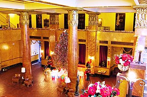
Gadsden Hotel
United States historic place in Cochise County, Arizona
Distance: Approx. 847 meters
Latitude and longitude: 31.34527778,-109.55416667
The Gadsden Hotel is a historic hotel in Douglas, Arizona. It was listed on the U.S. National Register of Historic Places in 1976.

United States Post Office and Customs House–Douglas Main
United States historic place
Distance: Approx. 711 meters
Latitude and longitude: 31.34472222,-109.55277778
The U.S. Post Office and Customs House-Douglas Main, also known as Douglas Post Office and Customs House or Douglas Main Post Office, is a Beaux-Arts building in Douglas, Arizona that was designed in 1912 and built in 1915. The building provided spaces for a post office, a custom house and Federal offices. It was listed on the National Register of Historic Places (NRHP) in 1985.
El Paso and Southwestern Railroad YMCA
United States historic place
Distance: Approx. 1081 meters
Latitude and longitude: 31.34444444,-109.55666667
The El Paso and Southwestern Railroad YMCA, also known as the Douglas YMCA, is a large brick building in Douglas, Arizona. It was listed on the National Register of Historic Places in 1984. It is a Mission Revival style building designed by architect Theodore C. Link.

Douglas Historic District
United States historic place
Distance: Approx. 795 meters
Latitude and longitude: 31.34527778,-109.55361111
The Douglas Historic District includes the commercial area of Douglas, Arizona, a mining company town established in 1901. The dates of the buildings' construction range from 1901 to 1935. The district is bordered on the south by the buildings on G and H Avenues between 15th and 8th Street, and lie only eight blocks from the United States - Mexico border.

Douglas Residential Historic District
United States historic place
Distance: Approx. 156 meters
Latitude and longitude: 31.34444444,-109.54694444
The Douglas Residential Historic District is an area located in Douglas, Arizona, consisting of almost 500 buildings, of which 325 are contributing structures to the District. Architectural styles include Late 19th and 20th Century Revival; Bungalow, Craftsman, Victorian, and Queen Anne.

Douglas Sonoran Historic District
United States historic place
Distance: Approx. 404 meters
Latitude and longitude: 31.34638889,-109.54166667
The Douglas Sonoran Historic District, called the Sonoran District, is an historic district located in Douglas, Arizona. It is southwest of the business district, its rough boundaries are H Avenue on the west, from 6th to 9th Street, consisting of contiguous flush-fronted, single story, Sonoran tradition row buildings built between 1901 and 1935. The majority of the buildings were constructed using local gypsum-cast stone.

Douglas Underpass
United States historic place
Distance: Approx. 1103 meters
Latitude and longitude: 31.35027778,-109.55472222
The Douglas Underpass is a concrete underpass in Douglas, Arizona, allowing U.S. Highway 80 (US 80) to pass under the Southern Pacific Railroad tracks in 1936. It was added to the National Register of Historic Places on June 30, 1988. In 1935 the underpass was engineered by the Arizona Highway Department, as a two-span reinforced concrete slab.
El Paso and Southwestern Railroad Passenger Depot-Douglas
United States historic place
Distance: Approx. 1143 meters
Latitude and longitude: 31.34944444,-109.55583333
The El Paso and Southwestern Railroad Depot is a Beaux Arts building constructed in 1913 in Douglas, Arizona. Two-stories tall, it was a major station on the El Paso and Southwestern Railroad line. It is slightly to the northwest of the Douglas Historic District, sitting on a 3.2331 acre parcel.
Weather in this IP's area
clear sky
4 Celsius
2 Celsius
4 Celsius
4 Celsius
1017 hPa
24 %
1017 hPa
870 hPa
10000 meters
2.57 m/s
50 degree
2 %


