206.12.213.84 - IP Lookup: Free IP Address Lookup, Postal Code Lookup, IP Location Lookup, IP ASN, Public IP
Country:
Region:
City:
Location:
Time Zone:
Postal Code:
ISP:
ASN:
language:
User-Agent:
Proxy IP:
Blacklist:
IP information under different IP Channel
ip-api
Country
Region
City
ASN
Time Zone
ISP
Blacklist
Proxy
Latitude
Longitude
Postal
Route
db-ip
Country
Region
City
ASN
Time Zone
ISP
Blacklist
Proxy
Latitude
Longitude
Postal
Route
IPinfo
Country
Region
City
ASN
Time Zone
ISP
Blacklist
Proxy
Latitude
Longitude
Postal
Route
IP2Location
206.12.213.84Country
Region
british columbia
City
castlegar
Time Zone
America/Vancouver
ISP
Language
User-Agent
Latitude
Longitude
Postal
ipdata
Country
Region
City
ASN
Time Zone
ISP
Blacklist
Proxy
Latitude
Longitude
Postal
Route
Popular places and events near this IP address

Kootenay River
River in Western Canada and the United States
Distance: Approx. 1362 meters
Latitude and longitude: 49.31666667,-117.65111111
The Kootenay River or Kootenai River is a major river of the Northwest Plateau in southeastern British Columbia, Canada, and northern Montana and Idaho in the United States. It is one of the uppermost major tributaries of the Columbia River, the largest North American river that empties into the Pacific Ocean. The Kootenay River runs 781 kilometres (485 mi) from its headwaters in the Kootenay Ranges of the Canadian Rockies, flowing from British Columbia's East Kootenay region into northwestern Montana, then west into the northernmost Idaho Panhandle and returning to British Columbia in the West Kootenay region, where it joins the Columbia at Castlegar.
Castlegar, British Columbia
City in British Columbia, Canada
Distance: Approx. 237 meters
Latitude and longitude: 49.32444444,-117.66694444
Castlegar is a community in the West Kootenay region of British Columbia, Canada. In the Selkirk Mountains, at the confluence of the Kootenay and Columbia Rivers, it is a regional trade and transportation centre, with a local economy based on forestry, mining and tourism. Castlegar is home to Selkirk College, a regional airport, a pulp mill, and several sawmills.

West Kootenay Regional Airport
Airport in Castlegar, British Columbia
Distance: Approx. 3995 meters
Latitude and longitude: 49.29611111,-117.6325
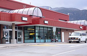
The West Kootenay Regional Airport (Castlegar Airport) (IATA: YCG, ICAO: CYCG) is a small regional airport located 2 nautical miles (3.7 km; 2.3 mi) south southeast of Castlegar, British Columbia, Canada. It serves the West Kootenay region, including Castlegar, Nelson and Trail. It is owned and operated by the City of Castlegar, and has a 15,317 sq ft (1,423 m2) passenger terminal.

Stanley Humphries Secondary School
High school in Castlegar, British Columbia, Canada
Distance: Approx. 663 meters
Latitude and longitude: 49.31997,-117.66069
Stanley Humphries Secondary, also known as "SHSS", is a public high school in Castlegar, British Columbia part of School District 20 Kootenay-Columbia. Stanley Humphries was founded in 1951 and continues to be open to the community. Stanley Humphries is the main Secondary School for the Castlegar area.
Kinnaird, British Columbia
Distance: Approx. 4841 meters
Latitude and longitude: 49.283,-117.65
Kinnaird (Scottish Gaelic: An Ceann Àrd, "high headland") is a neighbourhood comprising the southern part of Castlegar, British Columbia.
Robson/Raspberry
Distance: Approx. 1245 meters
Latitude and longitude: 49.336,-117.67
Robson/Raspberry is a designated place located north of Castlegar across the Columbia River combining two historical communities, Robson, formerly a steamboat landing and railway terminal, and Raspberry, formerly encompassing Sproat's Landing and later a Doukhobor colony. It has one school, Robson Community School.
Robson, British Columbia
Unincorporated community in southeastern British Columbia
Distance: Approx. 2216 meters
Latitude and longitude: 49.33444444,-117.69138889
Robson is an unincorporated community in the West Kootenay region of southeastern British Columbia. The former steamboat landing and railway terminal is on the northeast side of the Columbia River. The residential area is off Broadwater Road, within the northwest part of Greater Castlegar.
CKQR-FM
Radio station in Castlegar, British Columbia
Distance: Approx. 3050 meters
Latitude and longitude: 49.315,-117.62527778
CKQR-FM is a Canadian radio station that broadcasts a classic rock format at 99.3 FM in Castlegar, British Columbia. The station is branded as The Goat and it is owned by the Vista Broadcast Group.

Brilliant Dam
Dam in Central Kootenay, British Columbia, Canada
Distance: Approx. 3201 meters
Latitude and longitude: 49.32472222,-117.62
Brilliant Dam is a hydroelectric dam on the Kootenay River near Castlegar, British Columbia, Canada. It was built during the Second World War, mostly by Doukhobour men exempt from military service, and its 129 MW twin turbines first came into operation in June, 1944. The Columbia Power Corporation purchased the dam from Teck Cominco in 1996.
Raspberry, British Columbia
Distance: Approx. 1218 meters
Latitude and longitude: 49.3355,-117.6573
Raspberry is an unincorporated community in the West Kootenay region of southeastern British Columbia. On the northeast side of the Columbia River adjacent to the mouth of Norns (formerly Pass) Creek, the residential area is part of Greater Castlegar.
Brilliant, British Columbia
Human settlement in British Columbia, Canada
Distance: Approx. 1485 meters
Latitude and longitude: 49.323,-117.644
Brilliant is in the West Kootenay region of southeastern British Columbia. The locality is on the northeast side of the Columbia River, and on the west shore at the mouth of the Kootenay River. This minor residential area, west of Highway 3A, is part of Greater Castlegar.
Brilliant Suspension Bridge
Suspension bridge over the Kootenay River
Distance: Approx. 2650 meters
Latitude and longitude: 49.31751389,-117.62969167
The Brilliant Suspension Bridge is a suspension bridge over the Kootenay River near Castlegar, British Columbia. It was built in 1913 by Doukhobors settled in the area to replace a ferry across the river. In 1966, the new Highway 3A bridge replaced this one, and it was abandoned.
Weather in this IP's area
scattered clouds
-16 Celsius
-21 Celsius
-16 Celsius
-16 Celsius
1038 hPa
96 %
1038 hPa
884 hPa
10000 meters
2.17 m/s
3 m/s
320 degree
42 %

