205.60.134.25 - IP Lookup: Free IP Address Lookup, Postal Code Lookup, IP Location Lookup, IP ASN, Public IP
Country:
Region:
City:
Location:
Time Zone:
Postal Code:
IP information under different IP Channel
ip-api
Country
Region
City
ASN
Time Zone
ISP
Blacklist
Proxy
Latitude
Longitude
Postal
Route
Luminati
Country
ASN
Time Zone
America/Chicago
ISP
DNIC-ASBLK-05120-05376
Latitude
Longitude
Postal
IPinfo
Country
Region
City
ASN
Time Zone
ISP
Blacklist
Proxy
Latitude
Longitude
Postal
Route
IP2Location
205.60.134.25Country
Region
virginia
City
virginia beach
Time Zone
America/New_York
ISP
Language
User-Agent
Latitude
Longitude
Postal
db-ip
Country
Region
City
ASN
Time Zone
ISP
Blacklist
Proxy
Latitude
Longitude
Postal
Route
ipdata
Country
Region
City
ASN
Time Zone
ISP
Blacklist
Proxy
Latitude
Longitude
Postal
Route
Popular places and events near this IP address
Atlantic University
Distance: Approx. 1597 meters
Latitude and longitude: 36.89275,-75.99022222
Atlantic University is a private university in Virginia Beach, Virginia. The university is associated with Edgar Cayce's Association for Research and Enlightenment (A.R.E.), and its administrative offices are in the Don and Nancy de Laski Education Center on the main A.R.E. campus. The university is accredited by the Distance Education Accrediting Commission (DEAC) and licensed by the State Council of Higher Education for Virginia (SCHEV).
Association for Research and Enlightenment
Organization devoted to American clairvoyant Edgar Cayce
Distance: Approx. 1611 meters
Latitude and longitude: 36.89277778,-75.99
The Association for Research and Enlightenment (A.R.E.), also known as Edgar Cayce's A.R.E., is a non-profit organization founded in 1931 by clairvoyant Edgar Cayce to explore spirituality, holistic health, and other psychic topics, as well as preserving historical resources, including Cayce’s psychic readings. A.R.E. engages in holistic health services, workshops, conferences and retreats, and publishes materials relating to Edgar Cayce and his teachings. Its headquarters is in Virginia Beach, Virginia, in the United States, and there are reportedly Edgar Cayce Centers in 37 countries.

First Landing State Park
State park in Virginia, USA
Distance: Approx. 2992 meters
Latitude and longitude: 36.90611111,-76.01527778
First Landing State Park (formerly Seashore State Park) offers recreational opportunities at Cape Henry in the independent city of Virginia Beach, Virginia. As the first planned state park of Virginia, First Landing is listed on the National Register of Historic Places as Seashore State Park Historic District. A portion of the park is listed as a National Natural Landmark as part of the Seashore Natural Area.
First Colonial High School
High school in Virginia Beach, Virginia, United States
Distance: Approx. 2584 meters
Latitude and longitude: 36.87333333,-76.02861111
First Colonial High School is a high school in Virginia Beach, Virginia. It is a part of the Virginia Beach City Public Schools, serving 1,807 students (2021-22).
Alanton, Virginia
Neighborhood in Virginia Beach, Virginia, United States
Distance: Approx. 1825 meters
Latitude and longitude: 36.88277778,-76.02194444
Alanton is an older, upscale, residential neighborhood in the northern part of Virginia Beach, Virginia, United States. The community was named for Alan McCullough, a prominent Virginia architect, but developed by his father. It is bordered by Baycliff and Cape Henry Collegiate School.
Cape Henry Collegiate School
Private, college-prep, day school in Virginia Beach, Virginia, United States
Distance: Approx. 2537 meters
Latitude and longitude: 36.87694444,-76.02938889
Cape Henry Collegiate (formerly Cape Henry Collegiate School, also known as Cape Henry or CHC) is a private, college-preparatory, coeducational, day school located in Virginia Beach, Virginia.
Andrew B. Cooke House
House in Virginia
Distance: Approx. 1184 meters
Latitude and longitude: 36.877203,-75.989394
The Andrew B. Cooke House in Virginia Beach, Virginia, was designed in 1953 and completed in 1959 for Andrew B. & Maude Cooke. Along with the Pope-Leighey House and the Luis Marden House, it is one of three Frank Lloyd Wright designs in Virginia. A variation of Wright's solar hemicycle designs, the Cooke House features yellow-gold brick and a copper, cantilevered roof.
Dr. John Miller-Masury House
Historic house in Virginia, United States
Distance: Approx. 858 meters
Latitude and longitude: 36.87833333,-75.99277778
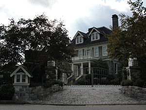
Dr. John Miller-Masury House, also known as Lakeside (1906–1935), Crystal Club (1935–1939), and Greystone Manor (1942-present), is a historic home located at Virginia Beach, Virginia. It was built in 1906–1908, and is a 2+1⁄2-story, five-bay, L-shaped stone-and-slate dwelling.
Shirley Hall
Historic house in Virginia, United States
Distance: Approx. 1077 meters
Latitude and longitude: 36.87333333,-76.00777778
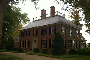
Shirley Hall, also known as Devereaux House, is a historic home located at Virginia Beach, Virginia. It was built in 1940, and is a two-story, five-bay, Georgian Revival style brick dwelling. The main block is covered by a hipped roof with balustrade.
Briarwood (Virginia Beach, Virginia)
Historic house in Virginia, United States
Distance: Approx. 2551 meters
Latitude and longitude: 36.86083333,-76.01361111
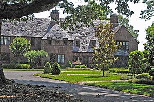
Briarwood, also known as Bingham House, is a historic home located at Virginia Beach, Virginia. It was built in 1932, and is a two-story, 6,000 square foot, Tudor Revival style brick dwelling. It features steeply pitched gabled and hipped roof elements clad in historic slate shingles as well as three corbelled brick chimneys.

Cavalier Hotel
United States historic place
Distance: Approx. 2167 meters
Latitude and longitude: 36.86916667,-75.98277778
The Cavalier Hotel is a historic hotel building at 4200 Atlantic Avenue in Virginia Beach, Virginia. The seven-story building was designed by Neff and Thompson with a Y-shaped floor plan and was completed in 1927. Most of its hotel rooms featured views of the Atlantic Ocean, and all had private bathrooms.
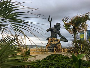
King Neptune (statue)
Bronze statue in Virginia
Distance: Approx. 3260 meters
Latitude and longitude: 36.85963,-75.9773
King Neptune is a large bronze statue located in Virginia Beach, Virginia designed by Paul DiPasquale. It stands at the entrance of Neptune Park on the Virginia Beach Boardwalk at 31st Street, and depicts the mythological god Neptune. The sculpture weighs 12.5 tons and is 34 feet (10 m) tall.
Weather in this IP's area
clear sky
2 Celsius
-3 Celsius
-1 Celsius
2 Celsius
1014 hPa
65 %
1014 hPa
1013 hPa
10000 meters
5.66 m/s
10.29 m/s
340 degree
