205.251.164.8 - IP Lookup: Free IP Address Lookup, Postal Code Lookup, IP Location Lookup, IP ASN, Public IP
Country:
Region:
City:
Location:
Time Zone:
Postal Code:
ISP:
ASN:
language:
User-Agent:
Proxy IP:
Blacklist:
IP information under different IP Channel
ip-api
Country
Region
City
ASN
Time Zone
ISP
Blacklist
Proxy
Latitude
Longitude
Postal
Route
db-ip
Country
Region
City
ASN
Time Zone
ISP
Blacklist
Proxy
Latitude
Longitude
Postal
Route
IPinfo
Country
Region
City
ASN
Time Zone
ISP
Blacklist
Proxy
Latitude
Longitude
Postal
Route
IP2Location
205.251.164.8Country
Region
ohio
City
toledo
Time Zone
America/New_York
ISP
Language
User-Agent
Latitude
Longitude
Postal
ipdata
Country
Region
City
ASN
Time Zone
ISP
Blacklist
Proxy
Latitude
Longitude
Postal
Route
Popular places and events near this IP address

Vistula Historic District
Historic district in Ohio, United States
Distance: Approx. 244 meters
Latitude and longitude: 41.65777778,-83.52666667
Vistula Historic District is a designated historic district in the city of Toledo, Ohio, USA, listed on the National Register of Historic Places. The district comprises Toledo's oldest extant neighborhood and encompasses an area roughly bounded by Champlain, Summit, Walnut and Magnolia streets. Vistula was a village established on land in what was then part of Michigan Territory, purchased in 1832 by Benjamin F. Stickney, in company with several investors from Lockport, New York, including Edward Bissell.

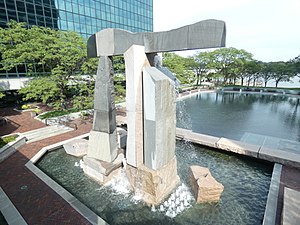
Propylaea (sculpture)
Sculpture by Dimitri Hadzi
Distance: Approx. 492 meters
Latitude and longitude: 41.652937,-83.531049
Propylaea is a sculpture/fountain on the Maumee River, in downtown Toledo, Ohio.

Imagination Station
Science museum in Ohio, United States
Distance: Approx. 612 meters
Latitude and longitude: 41.651904,-83.531468
Imagination Station (formerly the Center of Science and Industry (COSI)) is a non-profit, hands-on science museum located on the Maumee River in downtown Toledo, Ohio. The facility has over 300 exhibits for "children of all ages". The museum opened in 1997 as COSI. After tax levies failed in 2006 and 2007, COSI closed its doors to the public on the last day of 2007 due to lack of funding.

Armory Park
Distance: Approx. 566 meters
Latitude and longitude: 41.656297,-83.5362
Armory Park was a minor league baseball park in Toledo, Ohio. It was the home of the Toledo Mud Hens and their predecessors from 1897 until mid-season 1909 when Swayne Field opened. Armory Park is the first Toledo ballpark for which any photograph is known to survive.

James M. Ashley and Thomas W.L. Ashley United States Courthouse
United States historic place
Distance: Approx. 550 meters
Latitude and longitude: 41.6575,-83.5361
The James M. Ashley and Thomas W.L. Ashley United States Courthouse, formerly the United States Courthouse, Toledo, Ohio, is a courthouse of the United States District Court for the Northern District of Ohio built in Toledo, Ohio, in 1932. It is named for two former Congressmen, Republican James M. Ashley, and his great grandson, Democrat Thomas W. L. Ashley.

Valentine Theatre
Distance: Approx. 627 meters
Latitude and longitude: 41.6528,-83.5342
The Valentine Theatre is located in the downtown district of Toledo, Ohio at the corner of Superior and Adams Streets. The 129-year-old facility seats 901. From 1925 to approximately 1928 The Toledo Society for the Blind (Now the Sight Center of Northwest Ohio) rented space there for their operations.

Lucas County Courthouse and Jail
United States historic place
Distance: Approx. 677 meters
Latitude and longitude: 41.65527778,-83.53722222
The Lucas County Courthouse is an architecturally-significant courthouse in downtown Toledo, Ohio, located at 700 Adams Street. The courthouse first opened in 1897. It was designed by David L. Stine, and the contractors were Dun, Perley & Co.

Trinity Episcopal Church (Toledo, Ohio)
Historic church in Ohio, United States
Distance: Approx. 613 meters
Latitude and longitude: 41.6525,-83.53333333
Trinity Episcopal Church is a historic Episcopal church at 316 Adams Street in Toledo, Ohio. It was built in 1863 in a Gothic Revival style. The building was added to the National Register in 1983.
Martin Luther King Bridge (Toledo, Ohio)
Bridge
Distance: Approx. 528 meters
Latitude and longitude: 41.652626,-83.527814
The Martin Luther King Memorial Bridge (formerly Cherry Street Bridge) is a double-leaf bascule bridge adjacent to downtown Toledo, Ohio, where Cherry Street crosses the Maumee River to become Main Street on the east side of the city. The structure opened to traffic in 1914.

Cherry Street, Toledo
Major east-west roadway in Toledo, Ohio, United States
Distance: Approx. 528 meters
Latitude and longitude: 41.652626,-83.527814
Cherry Street is a major east–west roadway in Toledo, Ohio. It crosses the Maumee River over the Martin Luther King Bridge, a bascule lift bridge, built in 1913. Toledo's first medical college was constructed at the corner of Cherry and Page streets, in 1896.
Toledo Fire & Rescue Department
Distance: Approx. 375 meters
Latitude and longitude: 41.656253,-83.5338306
The City of Toledo Department of Fire & Rescue Operations, or simply Toledo Fire & Rescue Department provides fire protection and emergency medical services for Toledo, Ohio. The department was established on November 27, 1837.

Ohio Building (Toledo, Ohio)
Office in Toledo, Ohio /
Distance: Approx. 768 meters
Latitude and longitude: 41.65183333,-83.53530556
The Ohio Building is a 178 ft (54 m) tall high-rise building located at 420 Madison Avenue in Downtown Toledo.
Weather in this IP's area
clear sky
2 Celsius
-4 Celsius
1 Celsius
3 Celsius
1008 hPa
47 %
1008 hPa
985 hPa
10000 meters
8.75 m/s
16.46 m/s
220 degree
