205.237.194.42 - IP Lookup: Free IP Address Lookup, Postal Code Lookup, IP Location Lookup, IP ASN, Public IP
Country:
Region:
City:
Location:
Time Zone:
Postal Code:
ISP:
ASN:
language:
User-Agent:
Proxy IP:
Blacklist:
IP information under different IP Channel
ip-api
Country
Region
City
ASN
Time Zone
ISP
Blacklist
Proxy
Latitude
Longitude
Postal
Route
db-ip
Country
Region
City
ASN
Time Zone
ISP
Blacklist
Proxy
Latitude
Longitude
Postal
Route
IPinfo
Country
Region
City
ASN
Time Zone
ISP
Blacklist
Proxy
Latitude
Longitude
Postal
Route
IP2Location
205.237.194.42Country
Region
florida
City
green cove springs
Time Zone
America/New_York
ISP
Language
User-Agent
Latitude
Longitude
Postal
ipdata
Country
Region
City
ASN
Time Zone
ISP
Blacklist
Proxy
Latitude
Longitude
Postal
Route
Popular places and events near this IP address

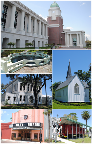
Green Cove Springs, Florida
City in Florida, United States of America
Distance: Approx. 6575 meters
Latitude and longitude: 29.99277778,-81.68388889
Green Cove Springs is a city in and the county seat of Clay County, Florida, United States. Green Cove Springs is a part of the Jacksonville, Florida Metropolitan Statistical Area. The population was 9,786 at the 2020 census, up from 6,908 at the 2010 census.

Penney Farms, Florida
Town in the state of Florida, United States
Distance: Approx. 7504 meters
Latitude and longitude: 29.98111111,-81.81
Penney Farms is a town in central Clay County, Florida, United States. It is part of the Jacksonville, Florida Metropolitan Statistical Area. The population was 821 at the 2020 census, up from 749 at the 2010 census.

Memorial Home Community Historic District
Historic district in Florida, United States
Distance: Approx. 7377 meters
Latitude and longitude: 29.98222222,-81.80805556
The Memorial Home Community Historic District (also known as Penney Retirement Community) is a U.S. historic district (designated as such on February 3, 1999) located in Penney Farms, Florida. The district is bounded by SR 16, Caroline Boulevard, Wilbanks Avenue, and Studio Road. It contains 24 historic buildings and 2 structures.

Green Cove Springs Historic District
Historic district in Florida, United States
Distance: Approx. 6905 meters
Latitude and longitude: 29.99388889,-81.68055556
The Green Cove Springs Historic District is a U.S. historic district (designated as such on March 28, 1991) located in Green Cove Springs, Florida. The district is bounded by Bay Street, CSX RR tracks, Center Street, Orange Avenue, St. Elmo Street and St.
Bubba Midden
United States historic place
Distance: Approx. 6696 meters
Latitude and longitude: 29.99,-81.68
The Bubba Midden is a historic site near Green Cove Springs, Florida. It is located on Fleming Island, northwest of Green Cove Springs. On March 2, 1990, it was added to the U.S. National Register of Historic Places.

Clay County Courthouse (Florida)
United States historic place
Distance: Approx. 6376 meters
Latitude and longitude: 29.99111111,-81.685
The Clay County Historic Courthouse is a historic county courthouse in Green Cove Springs, Florida. The two-story brick building was built in 1889 and used until 1973. A historical marker commemorates its history.

St. Mary's Episcopal Church (Green Cove Springs, Florida)
Historic church in Florida, United States
Distance: Approx. 7322 meters
Latitude and longitude: 29.99722222,-81.67805556
St. Mary's Episcopal Church is an historic Carpenter Gothic church located at 400 St. Johns Avenue in Green Cove Springs, Florida.
Clay County Fairgrounds
Distance: Approx. 2648 meters
Latitude and longitude: 29.98,-81.741
The Clay County Fairgrounds, officially known as the Paul E. Reinhold Agricultural Fairgrounds, are fairgrounds located in Green Cove Springs, in Clay County, Florida, United States. Located on 28 acres (110,000 m2) first donated to the county by Paul and Klare Reinhold in 1972, the site hosts the annual Clay County Agricultural Fair, which was first held in 1987. The fairgrounds contain several indoor and outdoor venues, one of which was the intended home to the Green Cove Lions of the National Indoor Football League in 2007.
Clay High School (Green Cove Springs, Florida)
Public school
Distance: Approx. 3741 meters
Latitude and longitude: 29.982342,-81.712937
Clay High School is a four-year high school located in Green Cove Springs, Florida. It is a part of the Clay County School District.
Virginia Village, Florida
Unincorporated community in Florida, U.S.
Distance: Approx. 6659 meters
Latitude and longitude: 29.9206,-81.6823
Virginia Village is an unincorporated community in Clay County, Florida, United States. It is located along US 17 at the intersection with Clay CR 226, and has an airstrip named Haller Airpark. The historic Bellamy Road also ran through the community, and currently survives as a dirt road intersecting the southbound lanes of US 17 with a historic marker on the northwest corner.
Clay County Historical Museum
Museum in Florida, United States
Distance: Approx. 6406 meters
Latitude and longitude: 29.99126,-81.68474
The Clay County Historical Society Museum is located in Green Cove Springs, Clay County, Florida. It is located in the 1890 Courthouse Annex. Exhibits include a country kitchen, a music room, doll room, vault, climb aboard wooden caboose, fully equipped railroad transfer station and a country store.

Naval Air Station Lee Field
Former US Naval Air Station anb Reserve Fleet installation
Distance: Approx. 8739 meters
Latitude and longitude: 29.978117,-81.650523
Naval Air Station Lee Field was a United States Navy air base that opened on September 11, 1940, in Green Cove Springs, Florida to support the World War II efforts. The Air Station was on the St. Johns River in Clay County, Florida.
Weather in this IP's area
clear sky
7 Celsius
7 Celsius
5 Celsius
7 Celsius
1030 hPa
82 %
1030 hPa
1027 hPa
10000 meters
0.89 m/s
2.24 m/s
24 degree
3 %
