205.233.93.75 - IP Lookup: Free IP Address Lookup, Postal Code Lookup, IP Location Lookup, IP ASN, Public IP
Country:
Region:
City:
Location:
Time Zone:
Postal Code:
IP information under different IP Channel
ip-api
Country
Region
City
ASN
Time Zone
ISP
Blacklist
Proxy
Latitude
Longitude
Postal
Route
Luminati
Country
ASN
Time Zone
America/Toronto
ISP
NEXUSDS
Latitude
Longitude
Postal
IPinfo
Country
Region
City
ASN
Time Zone
ISP
Blacklist
Proxy
Latitude
Longitude
Postal
Route
IP2Location
205.233.93.75Country
Region
ontario
City
brampton
Time Zone
America/Toronto
ISP
Language
User-Agent
Latitude
Longitude
Postal
db-ip
Country
Region
City
ASN
Time Zone
ISP
Blacklist
Proxy
Latitude
Longitude
Postal
Route
ipdata
Country
Region
City
ASN
Time Zone
ISP
Blacklist
Proxy
Latitude
Longitude
Postal
Route
Popular places and events near this IP address

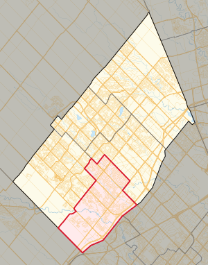
Brampton South (provincial electoral district)
Provincial electoral district in Ontario, Canada
Distance: Approx. 1664 meters
Latitude and longitude: 43.656,-79.757
Brampton South is a provincial electoral district in Ontario. It was created prior to the 1987 election from part of Brampton. It was abolished in 1999 into Bramalea—Gore—Malton—Springdale, Brampton Centre, Brampton West—Mississauga.

Shoppers World Brampton
Shopping mall in Ontario, Canada
Distance: Approx. 3598 meters
Latitude and longitude: 43.66616111,-79.73751389
Shoppers World Brampton is a shopping mall in Brampton, Ontario, Canada. It is host to over 190 stores, including Canadian Tire, Winners and Staples.

Korean War Memorial Wall (Canada)
Memorial to Canadians who served in the Korean War
Distance: Approx. 2050 meters
Latitude and longitude: 43.64194444,-79.74916667
The Korea Veterans Association of Canada erected a Wall of Remembrance to the 516 Canadians who are commemorated in the Korean War Book of Remembrance. The Wall was dedicated on July 27, 1997 and is located at Brampton, Ontario's Meadowvale Cemetery. The idea of a Wall of Remembrance came about when two members of Unit 57 of Korea Veterans Association (K.V.A.) were gathering information about a specific comrade who had been killed in Korea and a member of the family requested a picture of the comrades' grave in Pusan.
Camp Naivelt
Jewish camping community in Ontario, Canada
Distance: Approx. 833 meters
Latitude and longitude: 43.6447,-79.7834
Camp Naivelt (Yiddish: קעמפּ נײַוועלט, lit. 'Camp New World') is a left-wing secular Jewish camping community in Brampton, Ontario, founded in 1925 as a children's summer camp, Camp Kinderland (Yiddish: קעמפּ קינדערלאַנד). It is affiliated with the United Jewish People's Order.
Brampton Centennial Secondary School
High school in Brampton, Ontario, Canada
Distance: Approx. 3049 meters
Latitude and longitude: 43.66694444,-79.7475
Brampton Centennial Secondary School (BCSS) is a public high school located in Brampton, Ontario, Canada and is part of the Peel District School Board. In September 2008, BCSS had 1,775 students.
Brampton Centennial Secondary School shooting
School shooting
Distance: Approx. 3003 meters
Latitude and longitude: 43.667456,-79.749128
The Brampton Centennial Secondary School shooting was a school shooting that occurred at Brampton Centennial Secondary School in Brampton, Ontario, Canada on Wednesday, May 28, 1975, at 11:35 a.m. The school closed for the remainder of the week following the shooting, and re-opened the following Monday.

Churchville, Brampton
Unincorporated community in Ontario, Canada
Distance: Approx. 2395 meters
Latitude and longitude: 43.63,-79.75555556
Churchville is a preserved suburban hamlet in the south-west corner of Brampton, Ontario, Canada. The village was designated as a heritage conservation district under the Ontario Heritage Act in 1990, making it Brampton's only heritage conservation district.
St. Augustine Catholic Secondary School
School in Brampton, Ontario, Canada
Distance: Approx. 1422 meters
Latitude and longitude: 43.65827,-79.76503
St. Augustine Catholic Secondary School is a Catholic high school in Brampton, Ontario. This high school is part of the Dufferin-Peel Catholic District School Board.
St. Roch Catholic Secondary School
Catholic high school in Credit Valley, Canada
Distance: Approx. 3927 meters
Latitude and longitude: 43.67296,-79.80677
St. Roch Catholic Secondary School is a high school in Credit Valley, Brampton, Ontario, Canada. The school's principal is Natalie Currah.
David Suzuki Secondary School
High school in Brampton, Ontario, Canada
Distance: Approx. 2496 meters
Latitude and longitude: 43.6678,-79.7855
David Suzuki Secondary School is an institution located in Brampton, Ontario, Canada. The school is named after Canadian environmental activist David Suzuki. The school draws most of its students from the area bounded by Queen Street West, Hurontario Street, Bovaird Drive West, and Mississauga Road.
Brampton Gateway Terminal
Distance: Approx. 3837 meters
Latitude and longitude: 43.66583333,-79.73361111
Brampton Gateway Terminal is a Brampton Transit bus station serving the south-central and western areas of Brampton, Ontario. It is located on the north-west corner of Steeles Avenue and Main Street adjoining the Shoppers World Brampton shopping centre. The terminal opened on November 26, 2012 to replace the Shoppers World Terminal on the south-west side of the shopping centre.

Brampton South (federal electoral district)
Federal electoral district in Ontario, Canada
Distance: Approx. 1664 meters
Latitude and longitude: 43.656,-79.757
Brampton South (French: Brampton-Sud) is a federal electoral district in the Peel Region of Ontario. Brampton South was created by the 2012 federal electoral boundaries redistribution and was legally defined in the 2013 representation order. It came into effect upon the call of the 42nd Canadian federal election, scheduled for October 2015.
Weather in this IP's area
light snow
-3 Celsius
-9 Celsius
-4 Celsius
-3 Celsius
1019 hPa
83 %
1019 hPa
991 hPa
10000 meters
5.66 m/s
10 degree
100 %
