Country:
 Canada
Region:
City:
Latitude and Longitude:
Time Zone:
Postal Code:
IP information under different IP Channel
ip-api
Country
Region
City
ASN
Time Zone
ISP
Blacklist
Proxy
Latitude
Longitude
Postal
Route
Luminati
Country
CAASN
Time Zone
America/Toronto
ISP
ATGS-MMD-AS
Latitude
Longitude
Postal
IPinfo
Country
Region
City
ASN
Time Zone
ISP
Blacklist
Proxy
Latitude
Longitude
Postal
Route
db-ip
Country
Region
City
ASN
Time Zone
ISP
Blacklist
Proxy
Latitude
Longitude
Postal
Route
ipdata
Country
Region
City
ASN
Time Zone
ISP
Blacklist
Proxy
Latitude
Longitude
Postal
Route
Popular places and events near this IP address

Agincourt, Toronto
Neighbourhood in Toronto, Ontario, Canada
Distance: Approx. 1581 meters
Latitude and longitude: 43.7925,-79.28388889
Agincourt () is a neighbourhood and former village in Toronto, Ontario, Canada. Agincourt is located in northeast Toronto, along Sheppard Avenue between Kennedy and Markham Roads (north-south includes lands between Highway 401 and Finch Avenue). Before the creation of the "megacity" of Toronto in 1998, the area was part of Scarborough.

Ellesmere station
Toronto subway station
Distance: Approx. 1411 meters
Latitude and longitude: 43.76694444,-79.27638889
Ellesmere was a rapid transit station on Line 3 Scarborough of the Toronto subway in Toronto, Ontario, Canada. It was located at Ellesmere Road, between Kennedy Road and Midland Avenue. Ellesmere was the least-used station on the entire TTC network.

Midland station (Toronto)
Toronto subway station
Distance: Approx. 1319 meters
Latitude and longitude: 43.77041667,-79.27194444
Midland was a rapid transit station on Line 3 Scarborough of the Toronto subway in Toronto, Ontario, Canada. It is located on Midland Avenue between Ellesmere Road and Progress Avenue.

Agincourt GO Station
GO Transit railway station in Ontario, Canada
Distance: Approx. 870 meters
Latitude and longitude: 43.78611111,-79.28444444
Agincourt GO Station is a GO Transit railway station in Toronto, Ontario, Canada. The Stouffville line station serves the Agincourt neighbourhood of the former suburb of Scarborough.
Agincourt Collegiate Institute
Public high school in Toronto, Ontario, Canada
Distance: Approx. 1246 meters
Latitude and longitude: 43.78888889,-79.27916667
Agincourt Collegiate Institute (known locally as ACI or Agincourt), formerly known as Agincourt High School and Agincourt Continuation School is a secondary school in Toronto, Ontario, Canada. It is located in Agincourt, a neighbourhood in the former suburb of Scarborough. It was owned and operated by the Scarborough Board of Education prior to it being amalgamated into the Toronto District School Board in 1998.

Knox United Church (Scarborough)
Church in Ontario, Canada
Distance: Approx. 989 meters
Latitude and longitude: 43.78611111,-79.27833333
The Knox United Church, began as Knox Presbyterian Church in Scarborough, Toronto, Ontario, Canada, in a wood-frame church built in 1848, the result of the Church of Scotland disruption, that led to the formation of the Presbyterian Church of Canada in Connection with the Free Church of Scotland. Elder William Clarke, Sr., was one of the group who withdrew from the "Auld Kirk" at the Synod Meeting held in Kingston, Canada West in July, 1844; his Minister, Rev. James George, and much of the Presbyterian Church at Scarborough in Connection with the Church of Scotland (now St.
Thamil Isai Kalaamanram
Canadian Carnatic music organization
Distance: Approx. 549 meters
Latitude and longitude: 43.7815,-79.279
Thamil Isai Kalaamanram (Tamil: தமிழ் இசை கலாமன்றம்) (TIKM) is a non-profit organization dedicated to promoting carnatic music and bharathanatyam dance in Ontario, Canada, headquartered in Toronto. Founded in 1992, this Toronto-based organization has grown to become the widely accepted conservatory of South Indian music and dance, servicing over 160 classical music teachers in Canada.

Tam O'Shanter-Sullivan
Neighbourhood in Toronto, Ontario, Canada
Distance: Approx. 1757 meters
Latitude and longitude: 43.78805556,-79.30138889
Tam O'Shanter-Sullivan is a neighbourhood in the east end of the city of Toronto, Ontario, Canada, in the district of Scarborough. The neighbourhood is bordered by Huntingwood Drive to the North, Kennedy Road to the East, Highway 401 to the South and Victoria Park (and Pharmacy Ave) to the West. The neighbourhood, which includes the Tam O'Shanter (east of Warden) and Sullivan (west of Warden) communities, takes its name from Tam O’Shanter Golf Course and O'Sullivan's Corners.
Agincourt Mall
Shopping mall
Distance: Approx. 983 meters
Latitude and longitude: 43.7851,-79.292
Agincourt Mall is a shopping mall in Toronto, Ontario, Canada. It is located at the northwest corner of Kennedy Road and Sheppard Avenue, in the Tam O'Shanter – Sullivan neighbourhood of northeastern Toronto. It is named for the adjacent historic village and current Toronto neighbourhood of Agincourt.
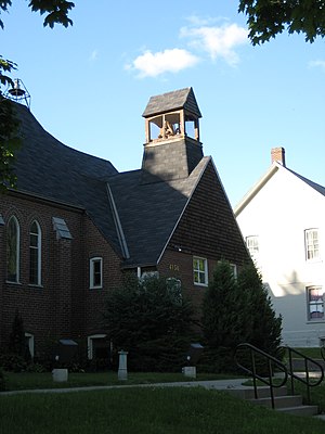
Knox Presbyterian Church (Agincourt)
Church in Ontario, Canada
Distance: Approx. 800 meters
Latitude and longitude: 43.7852,-79.2814
Knox Presbyterian Church is located at 4156 Sheppard Avenue East in the Agincourt neighbourhood of Toronto, Ontario, Canada. It was formed by former members of the "Historic" Knox Presbyterian Church (now Knox United Church) after that Presbyterian congregation voted 136-106 in 1925 to join the United Church of Canada. The new congregation was initially assisted by the Minister and Elders of St.

Sir William Osler High School
School in Toronto, Ontario, Canada
Distance: Approx. 2079 meters
Latitude and longitude: 43.796934,-79.285895
Sir William Osler High School (SWOHS), formerly Sir William Osler Vocational school is a small specialized public vocational high school in Toronto, Ontario, Canada. Located in the former suburb of Scarborough, it opened in 1975, and is named after Sir William Osler, a Canadian doctor and medical educator. Albert Campbell Collegiate Institute located northeast of Osler was initially named as Sir William Osler Collegiate Institute.
Toronto eSchool
Ontario secondary school - ossd online school
Distance: Approx. 1671 meters
Latitude and longitude: 43.76751,-79.29866
Toronto eSchool is an online high school and tutoring centre located in Toronto, Ontario, Canada. Toronto eSchool is inspected and approved by the Ontario Ministry of Education (BSID # 886520) to grant Ontario high school credits and the Ontario Secondary School Diploma (OSSD) itself since 2013. The tutoring centre offers both traditional tutoring and Maximize Your Success programs offered via seminars/webinars, workshops, academic programs, and test preparation classes.
Weather in this IP's area
clear sky
-1 Celsius
-4 Celsius
-3 Celsius
1 Celsius
1033 hPa
75 %
1033 hPa
1013 hPa
10000 meters
2.93 m/s
5.18 m/s
65 degree
2 %
07:09:40
16:53:31