205.194.32.41 - IP Lookup: Free IP Address Lookup, Postal Code Lookup, IP Location Lookup, IP ASN, Public IP
Country:
Region:
City:
Location:
Time Zone:
Postal Code:
ISP:
ASN:
language:
User-Agent:
Proxy IP:
Blacklist:
IP information under different IP Channel
ip-api
Country
Region
City
ASN
Time Zone
ISP
Blacklist
Proxy
Latitude
Longitude
Postal
Route
db-ip
Country
Region
City
ASN
Time Zone
ISP
Blacklist
Proxy
Latitude
Longitude
Postal
Route
IPinfo
Country
Region
City
ASN
Time Zone
ISP
Blacklist
Proxy
Latitude
Longitude
Postal
Route
IP2Location
205.194.32.41Country
Region
british columbia
City
victoria
Time Zone
America/Vancouver
ISP
Language
User-Agent
Latitude
Longitude
Postal
ipdata
Country
Region
City
ASN
Time Zone
ISP
Blacklist
Proxy
Latitude
Longitude
Postal
Route
Popular places and events near this IP address
Victoria City (federal electoral district)
Federal electoral district in British Columbia, Canada
Distance: Approx. 335 meters
Latitude and longitude: 48.43,-123.37
Victoria City was a federal electoral district in British Columbia, Canada, that was represented in the House of Commons of Canada from 1904 to 1924. This riding was created in 1903 from Victoria riding. It was identical at the time of its creation to the provincial electoral district of the same name.
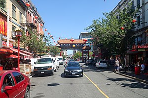
Chinatown, Victoria
Oldest Chinatown in Canada located in Victoria, British Columbia
Distance: Approx. 426 meters
Latitude and longitude: 48.429364,-123.367909
The Chinatown in Victoria, British Columbia is the oldest Chinatown in Canada and the second oldest in North America after San Francisco. Victoria's Chinatown had its beginnings in the mid-nineteenth century in the mass influx of miners from California to what is now British Columbia in 1858. It remains an actively inhabited place and continues to be popular with residents and visitors, many of whom are Chinese-Canadians.
Sail and Life Training Society
Christian organisation in Victoria, BC
Distance: Approx. 473 meters
Latitude and longitude: 48.42939,-123.37307
The Sail and Life Training Society (SALTS), founded in 1974, is a non-profit Christian organization based in Victoria, British Columbia. SALTS provides sail training and life lessons for 1,700 young people each year on tall ships and provides a valued link to the area's maritime heritage. Currently, SALTS administrative offices are located on Herald Street in downtown Victoria, with a shop space located nearby in the Rock Bay area.
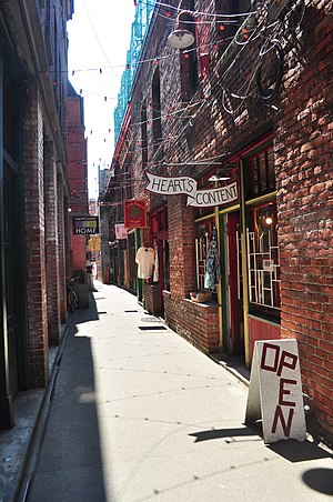
Fan Tan Alley
Alley in Victoria, British Columbia, Canada
Distance: Approx. 465 meters
Latitude and longitude: 48.429,-123.3679
Fan Tan Alley is an alley in the Chinatown neighbourhood of Victoria, British Columbia, Canada that is known for being the narrowest commercial street in North America, being less than 0.9 m (3.0 ft) wide at its narrowest point. It runs south from Fisgard Avenue to Pandora Avenue at the block between Government Street and Store Street. Named after the Chinese gambling game Fan-Tan, the alley was originally well known for opium factories that produced opium until it was made illegal in 1908.
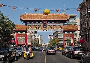
Gate of Harmonious Interest
Gate in Chinatown, Victoria, British Columbia
Distance: Approx. 439 meters
Latitude and longitude: 48.429379,-123.367334
The Gate of Harmonious Interest (Chinese: 同濟門; pinyin: Tóngjì mén) is a gate and cultural landmark located in Chinatown, Victoria, British Columbia. It spans Fisgard Street, west of Government Street. Erected in 1981, it was part of the revitalization efforts of Chinatown by the City of Victoria and the Chinese Consolidated Benevolent Association.
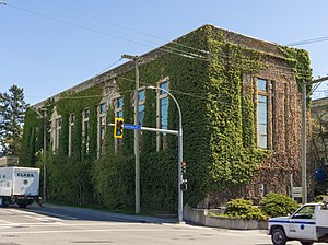
Bay Street Substation
Distance: Approx. 360 meters
Latitude and longitude: 48.4356,-123.3668
The Bay Street Substation is an historic building in Victoria, British Columbia, Canada. It is located downtown, at the intersection of Bay and Government Streets.

Hook Sin Tong Charity Building
Building in Victoria, British Columbia, Canada
Distance: Approx. 429 meters
Latitude and longitude: 48.43047111,-123.365315
The Hook Sin Tong Charity Building is an historic building in Victoria, British Columbia, Canada.
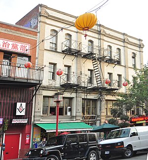
Loo Tai Cho Building
Distance: Approx. 448 meters
Latitude and longitude: 48.42917889,-123.36778694
The Loo Tai Cho Building is an historic building in Victoria, British Columbia, Canada.

On Hing Building
Restaurant in British Columbia, Canada
Distance: Approx. 402 meters
Latitude and longitude: 48.42954,-123.36813
The On Hing Building is an historic building in Victoria, British Columbia, Canada. It was built in 1891, but was only opened in 1901 according to BC Assessment e-value. It was always used for restaurants and commercial purposes.

Chinese Consolidated Benevolent Association Building
Distance: Approx. 415 meters
Latitude and longitude: 48.429535,-123.36764194
The Chinese Consolidated Benevolent Association Building is an historic building in Chinatown Victoria, British Columbia, Canada.

Gee Tuck Tong Benevolent Association Building
Clubhouse in Victoria, British Columbia
Distance: Approx. 471 meters
Latitude and longitude: 48.42954194,-123.36603389
The Gee Tuck Tong Benevolent Association Building is an historic building in Victoria, British Columbia, Canada.
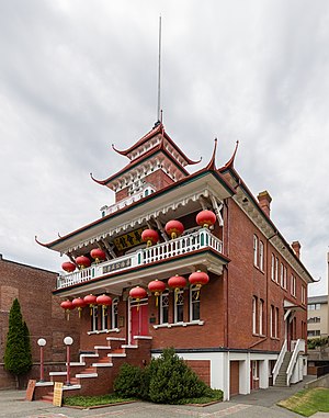
Chinese Consolidated Benevolent Association and Chinese Public School
Distance: Approx. 470 meters
Latitude and longitude: 48.42967194,-123.36579
The Chinese Consolidated Benevolent Association and Victoria Chinese Public School Chinese: (中華會館和域多利華僑公立學校) is a historic building located in the downtown core of Victoria, British Columbia, Canada. The Chinese Public School was built in 1909 by the Chinese Consolidated Benevolent Association (CCBA) in response to the racial and cultural segregation imposed by the school board and government, which banned Chinese students from City schools until they spoke English. The school continues to provide Cantonese and Mandarin-language education.
Weather in this IP's area
few clouds
8 Celsius
5 Celsius
7 Celsius
9 Celsius
1025 hPa
81 %
1025 hPa
1024 hPa
10000 meters
4.12 m/s
110 degree
20 %