205.189.200.68 - IP Lookup: Free IP Address Lookup, Postal Code Lookup, IP Location Lookup, IP ASN, Public IP
Country:
Region:
City:
Location:
Time Zone:
Postal Code:
IP information under different IP Channel
ip-api
Country
Region
City
ASN
Time Zone
ISP
Blacklist
Proxy
Latitude
Longitude
Postal
Route
Luminati
Country
Region
ut
City
ogden
ASN
Time Zone
America/Denver
ISP
OGDEN-CITY-CORPORATION
Latitude
Longitude
Postal
IPinfo
Country
Region
City
ASN
Time Zone
ISP
Blacklist
Proxy
Latitude
Longitude
Postal
Route
IP2Location
205.189.200.68Country
Region
utah
City
ogden
Time Zone
America/Denver
ISP
Language
User-Agent
Latitude
Longitude
Postal
db-ip
Country
Region
City
ASN
Time Zone
ISP
Blacklist
Proxy
Latitude
Longitude
Postal
Route
ipdata
Country
Region
City
ASN
Time Zone
ISP
Blacklist
Proxy
Latitude
Longitude
Postal
Route
Popular places and events near this IP address

West Haven, Utah
City in Utah, United States
Distance: Approx. 906 meters
Latitude and longitude: 41.22222222,-112.02777778
West Haven is a city in Weber County, Utah, United States. The population was estimated at 24,014 as of 2023. It was incorporated on July 1, 1991, combining the unincorporated communities of Kanesville and Wilson.

Ogden–Hinckley Airport
Airport near Ogden, Utah, United States
Distance: Approx. 2798 meters
Latitude and longitude: 41.19555556,-112.01305556
Ogden–Hinckley Airport (IATA: OGD, ICAO: KOGD, FAA LID: OGD) is a public airport four miles southwest of Ogden, in Weber County, Utah, United States. The National Plan of Integrated Airport Systems for 2019–2023 categorized it as a commercial service primary non-hub airport. Formerly Ogden Municipal Airport, it is billed as Utah's busiest municipal airport for private planes.

Stevens–Henager College
Private College in Ogden, Utah (1891–2021)
Distance: Approx. 1451 meters
Latitude and longitude: 41.23277778,-112.01138889
Stevens–Henager College was a private college headquartered in Ogden, Utah. It was founded in 1891 and closed abruptly in August 2021. It was one of four educational institutions affiliated with the Salt Lake City–based Center for Excellence in Higher Education (CEHE).

Independence University
Distance: Approx. 1451 meters
Latitude and longitude: 41.23277778,-112.01138889
Independence University (IU, formerly California College for Health Sciences) was a private online career college headquartered in Salt Lake City, Utah. It was the online branch of Stevens–Henager College, and operated four schools: the School of Healthcare, the School of Business, the School of Technology, and the School of Graphic Arts. IU was founded by Carl Barney and owned and operated by the Center for Excellence in Higher Education (CEHE).

Ogden River
River in Weber County, Utah, United States
Distance: Approx. 2005 meters
Latitude and longitude: 41.23472222,-112.0025
The Ogden River is a 35-mile (56 km) long river in Weber County. Utah, United States.

Fort Buenaventura
Distance: Approx. 2369 meters
Latitude and longitude: 41.214802,-111.989943
Fort Buenaventura, located in west Ogden, Utah, United States, was the first permanent Anglo settlement in the Great Basin. Built just east of the Weber River in 1846 by Miles Goodyear, the fort and its surrounding lands were purchased by Mormon settlers in 1847 and renamed Brownsville (then later Ogden). Following flooding along the river in 1850, the fort was abandoned.
Utah Cowboy and Western Heritage Museum
Hall of Fame for Cowboys
Distance: Approx. 3138 meters
Latitude and longitude: 41.22078,-111.97973
The Utah Cowboy and Western Heritage Museum, located in Ogden, Utah, is a state-recognized museum which collects and presents artifacts of the American frontier. It is situated in Ogden Union Station, along with the Utah State Railroad Museum, John M. Browning Firearms Museum, Kimball Classic Car Museum, and Myra Powell Gallery. The Cowboy Museum contains the Utah Cowboy Hall of Fame, which is associated with the Ogden Pioneer Heritage Foundation.

Ogden Nature Center
Nature preserve in Utah
Distance: Approx. 2927 meters
Latitude and longitude: 41.24472222,-112.00361111
The Ogden Nature Center is a 152-acre (0.62 km2) nature preserve and education center located in Ogden, Utah. Created in 1975, it was Utah's first nature center.

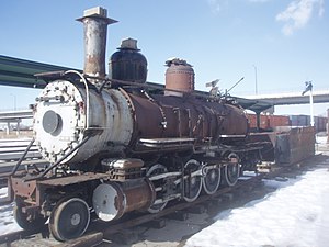
Rio Grande 223
American narrow-gauge steam locomotive
Distance: Approx. 3130 meters
Latitude and longitude: 41.22219444,-111.97988889
Denver and Rio Grande Western 223 is a 2-8-0 "Consolidation" type narrow-gauge steam locomotive built for the Denver and Rio Grande Railroad by the Grant Locomotive Works of Paterson, New Jersey in 1881–82. Number 223 was completed in December 1881, at a cost of $11,553. Rio Grande 223 is the only surviving narrow-gauge engine built by Grant Locomotive Works.
Utah State Industrial School
Reform school in the United States
Distance: Approx. 2935 meters
Latitude and longitude: 41.24583333,-112.0075
Utah State Industrial School was a juvenile reform school that operated in Ogden, Utah from October 31, 1889 to 1983.
Ogden Central station
Commuter rail station in Ogden, Utah, United States
Distance: Approx. 3099 meters
Latitude and longitude: 41.22444444,-111.98055556
Ogden Central station (formerly the Ogden Intermodal Transit Center) is a commuter rail train and bus station in Ogden, Utah, United States. It is served by the FrontRunner, Utah Transit Authority's (UTA) commuter rail train, the Ogden Express, a UTA bus rapid transit service, as well as UTA local and commuter bus service, and Greyhound Lines long-distance bus service.

Mountain View Auto Court
United States historic place
Distance: Approx. 2245 meters
Latitude and longitude: 41.22277778,-111.99055556
Mountain View Auto Court (also known as the Mountain View Motel) is a complex of motel buildings in southwestern Ogden, Utah, United States, that is listed on the National Register of Historic Places.
Weather in this IP's area
light rain
4 Celsius
-1 Celsius
2 Celsius
5 Celsius
1031 hPa
41 %
1031 hPa
879 hPa
10000 meters
5.81 m/s
7.6 m/s
38 degree
