205.177.199.99 - IP Lookup: Free IP Address Lookup, Postal Code Lookup, IP Location Lookup, IP ASN, Public IP
Country:
Region:
City:
Location:
Time Zone:
Postal Code:
ISP:
ASN:
language:
User-Agent:
Proxy IP:
Blacklist:
IP information under different IP Channel
ip-api
Country
Region
City
ASN
Time Zone
ISP
Blacklist
Proxy
Latitude
Longitude
Postal
Route
db-ip
Country
Region
City
ASN
Time Zone
ISP
Blacklist
Proxy
Latitude
Longitude
Postal
Route
IPinfo
Country
Region
City
ASN
Time Zone
ISP
Blacklist
Proxy
Latitude
Longitude
Postal
Route
IP2Location
205.177.199.99Country
Region
virginia
City
herndon
Time Zone
America/New_York
ISP
Language
User-Agent
Latitude
Longitude
Postal
ipdata
Country
Region
City
ASN
Time Zone
ISP
Blacklist
Proxy
Latitude
Longitude
Postal
Route
Popular places and events near this IP address

Herndon, Virginia
Town in Virginia, United States
Distance: Approx. 771 meters
Latitude and longitude: 38.97138889,-77.38861111
Herndon is a town in Fairfax County, Virginia, United States, part of the Washington, D.C., metropolitan area. In 2020, the population at the census was 24,655, which makes it the largest of three incorporated towns in the county. The actual dimensions of the town of Herndon are fairly small.

Young America's Foundation
American political youth organization
Distance: Approx. 2225 meters
Latitude and longitude: 38.9676,-77.3652
Young America's Foundation (YAF) is a 501(c)(3) nonprofit conservative youth organization founded in 1969. In 2018, the Los Angeles Times called YAF "one of the most preeminent, influential and controversial forces in the nation's conservative youth movement." Scott Walker, former governor of Wisconsin and 2016 Republican presidential candidate, became President of YAF on February 1, 2021. Notable alumni members include Jeff Sessions and Stephen Miller.
Herndon High School
High school in Herndon, Virginia
Distance: Approx. 1367 meters
Latitude and longitude: 38.98613889,-77.37494444
Herndon High School is a fully accredited four-year public high school in Herndon, Virginia, United States. Herndon serves grades 9-12 and is a part of the Fairfax County Public Schools (FCPS) system. Herndon High School serves the town of Herndon and the northern part of the unincorporated community of Reston.

Herndon station
Washington Metro station
Distance: Approx. 2832 meters
Latitude and longitude: 38.9528,-77.3852
Herndon station (preliminary names: Herndon–Monroe, Herndon–Reston West) is a Washington Metro station in Fairfax County, Virginia on the Silver Line that opened on November 15, 2022. The station is in the median strip of VA-267 adjacent to the current Herndon-Monroe Park and Ride parking garage and bus station, which is on the south side of the highway. It has two pedestrian bridges across SR 267 to reach entrances on either side of the highway.

Innovation Center station
Washington Metro station
Distance: Approx. 3138 meters
Latitude and longitude: 38.96083333,-77.41555556
Innovation Center station (preliminary names Route 28, Herndon – Dulles East) is a Washington Metro station in Fairfax County, Virginia on the Silver Line. It is located adjacent to the Virginia Center for Innovative Technology at the intersection of the SR 267 and SR 28 in McNair, near the Fairfax / Loudoun county line. Originally planned to begin operation in 2016, the station opened on November 15, 2022.

Dranesville, Virginia
Census-designated place in Virginia, United States
Distance: Approx. 2974 meters
Latitude and longitude: 38.99777778,-77.36361111
Dranesville is a census-designated place (CDP) in Fairfax County, Virginia, United States. Dranesville is located on the Leesburg Pike (State Route 7) at its intersection with Georgetown Pike (State Route 193). The U.S. Census Bureau defines Dranesville as a census-designated place (CDP) with a population of 11,921 as of 2010.
Oak Grove, Loudoun County, Virginia
Census-designated place in Virginia
Distance: Approx. 2830 meters
Latitude and longitude: 38.98472222,-77.41861111
Oak Grove is a census-designated place in Loudoun County, Virginia, United States. The population as of the 2010 United States Census was 1,777. Oak Grove is located in eastern Loudoun County, on the Fairfax County border, between the communities of Sterling Park and Herndon.
Cooktown, Virginia
Unincorporated community in Virginia, United States
Distance: Approx. 994 meters
Latitude and longitude: 38.98666667,-77.38333333
Cooktown is an unincorporated community in Fairfax County, Virginia, United States. It is located off Dranesville Road along Folly Lick Branch stream. Cooktown is named for the Cook family who settled in the area after the American Civil War.

Herndon Depot Museum
United States historic place
Distance: Approx. 898 meters
Latitude and longitude: 38.97019444,-77.38575
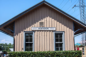
The Herndon Depot Museum, also known as the Herndon Historical Society Museum, is located in the town of Herndon in Fairfax County, Virginia. Built in 1857 for the Alexandria, Loudoun & Hampshire Railroad, the depot later served the Richmond and Danville Railroad, the Southern Railway and the Washington and Old Dominion Railroad. In 1875, the original shed was replaced with the current depot.
Herndon ArtSpace
Distance: Approx. 792 meters
Latitude and longitude: 38.9711,-77.3875
Herndon ArtSpace is a local art gallery, arts lab and performance space located in downtown Herndon, Virginia. Devoted to the development of visual arts and media, as well as small-scale musical, dramatic and film arts, Artspace has been supporting the developments of arts and artists within the Herndon community and Fairfax County, Virginia. ArtSpace is a place to celebrate the arts, showcasing artwork and events by local, regionally, and nationally known artists and performers.

Herndon Historic District
Historic district in Virginia, United States
Distance: Approx. 1116 meters
Latitude and longitude: 38.96833333,-77.38472222
Herndon Historic District is a national historic district located at Herndon, Fairfax County, Virginia. It encompasses 173 contributing buildings, 1 contributing site, and 1 contributing structure in the central business district and surrounding residential areas of Herndon. They include 104 houses, 20 commercial buildings, 6 institutional buildings, 4 industrial buildings, 30 garages, 8 barns, the pumphouse, the gas generating building, the water tower and the town square.
Hutchison, Virginia
Census-designated place in Virginia
Distance: Approx. 2379 meters
Latitude and longitude: 38.96472222,-77.40833333
Hutchison is a census designated place in Fairfax County, Virginia, United States. It is a residential development just north of Virginia State Route 267, located 23 miles west of Washington, D.C. The community is one of the census-designated places newly recognized for the 2020 United States census. As of the 2020 census, the population of Hutchison is 6,231.
Weather in this IP's area
clear sky
-2 Celsius
-2 Celsius
-4 Celsius
1 Celsius
1025 hPa
60 %
1025 hPa
1013 hPa
10000 meters