Country:
Region:
City:
Latitude and Longitude:
Time Zone:
Postal Code:
IP information under different IP Channel
ip-api
Country
Region
City
ASN
Time Zone
ISP
Blacklist
Proxy
Latitude
Longitude
Postal
Route
Luminati
Country
ASN
Time Zone
America/Chicago
ISP
OGERO
Latitude
Longitude
Postal
IPinfo
Country
Region
City
ASN
Time Zone
ISP
Blacklist
Proxy
Latitude
Longitude
Postal
Route
db-ip
Country
Region
City
ASN
Time Zone
ISP
Blacklist
Proxy
Latitude
Longitude
Postal
Route
ipdata
Country
Region
City
ASN
Time Zone
ISP
Blacklist
Proxy
Latitude
Longitude
Postal
Route
Popular places and events near this IP address

Marseille Cathedral
Roman Catholic cathedral in France
Distance: Approx. 460 meters
Latitude and longitude: 43.29972222,5.365
Marseille Cathedral (French: Cathédrale Sainte-Marie-Majeure de Marseille or Cathédrale de la Major) is a Roman Catholic cathedral and a national monument of France. Located in Marseille, it has been a basilica minor since 1896. It is the seat of the Archdiocese of Marseille (the Diocese of Marseille until its elevation in 1948).
Canton of Marseille-Belsunce
Former canton in Provence-Alpes-Côte d'Azur, France
Distance: Approx. 696 meters
Latitude and longitude: 43.29638889,5.37
Canton of Marseille-Belsunce (French: canton de Marseille-Belsunce; Occitan: canton de Marselha e Belsunce) is a former canton located within the commune of Marseille, Bouches-du-Rhône department, France. It was created 27 February 2003 by the decree 2003-156 of that date. It was disbanded following the French canton reorganisation which came into effect in March 2015.
Canton of Marseille-Verduron
Former canton in Provence-Alpes-Côte d'Azur, France
Distance: Approx. 696 meters
Latitude and longitude: 43.29638889,5.37
Canton of Marseille-Verduron is a former canton located within the commune of Marseille in the Bouches-du-Rhône department of France. It was created 27 February 2003 by the decree 2003-156 of that date. It was disbanded following the French canton reorganisation which came into effect in March 2015.

Porte d'Aix
Triumphal arch (national heritage monument of the 19th century) in Marseille, France
Distance: Approx. 470 meters
Latitude and longitude: 43.30179167,5.37476389
Porte d'Aix (also known as the Porte Royale) is a triumphal arch in Marseille, in the south of France, marking the old entry point to the city on the road from Aix-en-Provence. The classical design by Michel-Robert Penchaud was inspired by the triumphal arches of the Roman Empire. The Porte d’Aix was initially conceived in 1784 to honour Louis XVI and to commemorate the Peace of Paris (1783) that ended the American Revolutionary War.

Vieille Charité
Former almshouse in Marseille, France
Distance: Approx. 279 meters
Latitude and longitude: 43.30027778,5.36777778
La Vieille Charité is a former almshouse, now functioning as a museum and cultural centre, situated in the heart of the old Panier quarter of Marseille in the south of France. Constructed between 1671, and 1749, in the Baroque style to the designs of the architect Pierre Puget, it comprises four ranges of arcaded galleries in three storeys surrounding a space with a central chapel surmounted by an ovoid dome. The chapel and the hospice were classified as a historic monument by order of January 29, 1951.

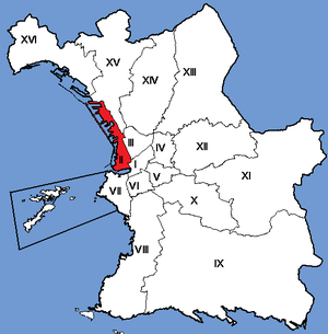
2nd arrondissement of Marseille
Municipal arrondissement in Provence-Alpes-Côte d'Azur, France
Distance: Approx. 692 meters
Latitude and longitude: 43.2964,5.3696
The 2nd arrondissement of Marseille is one of the 16 arrondissements of Marseille. It is governed locally together with the 3rd arrondissement, with which it forms the 2nd sector of Marseille.

Docks (Marseille)
Distance: Approx. 530 meters
Latitude and longitude: 43.30694444,5.36638889
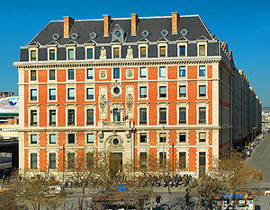
Les Docks de Marseille is a historical building in the heart of La Joliette, a business district in Marseille, France. The building is home to 220 companies employing some 3,500 people. Various corporate headquarters, regional branches, restaurants, and services are located inside.

La Joliette
Neighborhood in Marseille, France
Distance: Approx. 320 meters
Latitude and longitude: 43.305,5.3669
La Joliette (French pronunciation: [la ʒɔljɛt]; Occitan: La Jolieta) is a neighbourhood of the 2nd arrondissement of Marseille located at the start of the autonomous port of Marseille.

Marseille
Second-largest city in France
Distance: Approx. 694 meters
Latitude and longitude: 43.2964,5.37
Marseille or Marseilles (French: Marseille; Provençal Occitan: Marselha; see below) is the prefecture of the French department of Bouches-du-Rhône and of the Provence-Alpes-Côte d'Azur region. Situated in the Provence region of southern France, it is located on the coast of the Gulf of Lion, part of the Mediterranean Sea, near the mouth of the Rhône river. A resident of Marseille is a Marseillais.
Église Saint-Cannat
Church in Provence-Alpes-Côte d'Azur, France
Distance: Approx. 607 meters
Latitude and longitude: 43.2982,5.3735
The Église Saint-Cannat is a Roman Catholic church in Marseille.
Église Saint-Théodore
Church in Provence-Alpes-Côte d'Azur, France
Distance: Approx. 632 meters
Latitude and longitude: 43.3003,5.3762
The Église Saint-Théodore is a Roman Catholic church in Marseille, France.
Cantons of Marseille
Cantons in Provence-Alpes-Côte d'Azur, France
Distance: Approx. 299 meters
Latitude and longitude: 43.3,5.37
The cantons of Marseille are administrative divisions of the Bouches-du-Rhône department, in southeastern France. Since the French canton reorganisation which came into effect in March 2015, the city of Marseille is subdivided into 12 cantons. Their seat is in Marseille.
Weather in this IP's area
clear sky
21 Celsius
21 Celsius
19 Celsius
21 Celsius
1024 hPa
73 %
1024 hPa
1021 hPa
10000 meters
2.06 m/s
270 degree
07:16:28
17:27:38

