Country:
 USA
USARegion:
City:
Latitude and Longitude:
Time Zone:
Postal Code:
IP information under different IP Channel
ip-api
Country
Region
City
ASN
Time Zone
ISP
Blacklist
Proxy
Latitude
Longitude
Postal
Route
IPinfo
Country
Region
City
ASN
Time Zone
ISP
Blacklist
Proxy
Latitude
Longitude
Postal
Route
MaxMind
Country
Region
City
ASN
Time Zone
ISP
Blacklist
Proxy
Latitude
Longitude
Postal
Route
Luminati
Country
USRegion
md
City
bethesda
ASN
Time Zone
America/New_York
ISP
NACHA-HQ
Latitude
Longitude
Postal
db-ip
Country
Region
City
ASN
Time Zone
ISP
Blacklist
Proxy
Latitude
Longitude
Postal
Route
ipdata
Country
Region
City
ASN
Time Zone
ISP
Blacklist
Proxy
Latitude
Longitude
Postal
Route
Popular places and events near this IP address

Clarendon station
Washington Metro station
Distance: Approx. 361 meters
Latitude and longitude: 38.887102,-77.095192
Clarendon station is a side platformed Washington Metro station in the Clarendon neighborhood of Arlington, Virginia, United States. The station was opened on December 1, 1979, and is operated by the Washington Metropolitan Area Transit Authority (WMATA). The station serves the Orange and Silver Lines.

American Battle Monuments Commission
US government agency
Distance: Approx. 570 meters
Latitude and longitude: 38.89027778,-77.08666667
The American Battle Monuments Commission (ABMC) is an independent agency of the United States government that administers, operates, and maintains permanent U.S. military cemeteries, memorials and monuments primarily outside the United States. There were 26 cemeteries and 31 memorials, monuments and markers under the care of the ABMC. There are more than 140,000 U.S. servicemen and servicewomen interred at the cemeteries, and more than 94,000 missing in action, or lost or buried at sea are memorialized on cemetery Walls of the Missing and on three memorials in the United States. The ABMC also maintains an online database of names associated with each site.

Clarendon, Virginia
Neighborhood in Arlington, Virginia
Distance: Approx. 178 meters
Latitude and longitude: 38.88665,-77.09315
Clarendon is an urbanized, developed neighborhood in Arlington County, Virginia, located between the Rosslyn area and the Ballston area. It was named after Edward Hyde, 1st Earl of Clarendon, a leading statesman and historian of the English Civil War. The main thoroughfares are Wilson Boulevard (one-way westbound) and Clarendon Boulevard (one-way eastbound).
Arlington County Fire Department
Fire department of Arlington, US
Distance: Approx. 449 meters
Latitude and longitude: 38.88486111,-77.09583333
The Arlington County Fire Department (ACFD) provides fire, emergency medical, and allied public safety services for Arlington County and the City of Falls Church in Virginia, USA. It is highly regarded within the profession as an innovator and leader in enhancing the industry. Among its many firsts are the hiring of the first female career firefighter in the world in 1974 and partnering with the United States Public Health Service to develop America's first Metropolitan Medical Strike Team to respond to the consequences of a chemical, biological or radiological terrorist attack. The ACFD operates nine stations and is a signatory to an automatic regional response plan with neighboring Fairfax County as well as the city of Alexandria, and participates in a regional mutual aid pact with the District of Columbia and the Maryland counties of Montgomery and Prince George’s.
Leadership Institute
US nonprofit educational organization
Distance: Approx. 304 meters
Latitude and longitude: 38.88638889,-77.09461111
The Leadership Institute is a 501(c)(3) non-profit organization located in Arlington, Virginia that teaches "political technology." The institute was founded in 1979 by conservative activist Morton Blackwell. Its mission is to "increase the number and effectiveness of conservative activists" and to "identify, train, recruit and place conservatives in politics, government, and media." The Leadership Institute offers 44 types of training seminars at its Arlington headquarters, around the United States, and occasionally in foreign countries. In 2014, the Institute trained 18,182.

Lyon Village, Virginia
United States historic place
Distance: Approx. 641 meters
Latitude and longitude: 38.89138889,-77.095
Lyon Village is a neighborhood and urban village in Arlington County, Virginia, along Langston Boulevard (U.S. Route 29). It adjoins Arlington County's government center (including the courthouse and police/jail complex), and is approximately one mile west of Rosslyn and less than a mile north of Clarendon, of which it is sometimes considered a sub-neighborhood, as is Cherrydale, the mostly residential district immediately west of Lyon Village.
Arlington Line
Union Army fortifications around Washington, D.C. during the Civil War (1860s)
Distance: Approx. 723 meters
Latitude and longitude: 38.88958333,-77.08375
The Arlington Line was a series of fortifications that the Union Army erected in Alexandria County (now Arlington County), Virginia, to protect the City of Washington during the American Civil War (see Civil War Defenses of Washington and Washington, D.C., in the American Civil War). Just across the Potomac River from the Union capital city, Confederate Virginia was a major Union concern when the war began. In May 1861, federal troops seized much the County and immediately began constructing a group of forts near Washington on the Virginia side of the River to protect the capital city.
Institute for Law, Science and Global Security
Georgetown University institute
Distance: Approx. 368 meters
Latitude and longitude: 38.8878,-77.095
The Institute for Law, Science and Global Security in the Department of Government at Georgetown University was established to promote teaching and research in the area of intersection between international law and international relations. The Institute sponsors undergraduate and graduate courses and runs a Master's Program in International Law and Global Security. The Institute seeks to inform the public policy debate about the nature, role and importance of international law as it connected to issues of science and global security.
The Crossing Clarendon
Distance: Approx. 148 meters
Latitude and longitude: 38.88777778,-77.09158333
The Crossing Clarendon, formerly Market Common Clarendon, is an outdoor mixed-use development featuring retail, restaurants, and residential buildings located along Clarendon Boulevard in the Clarendon neighborhood of Arlington, Virginia. The complex was developed by McCaffery Interests, and opened in November 2001. The center features stores for fashion, electronics, groceries (Whole Foods Market), and dining.

United States Post Office (Arlington, Virginia)
United States historic place
Distance: Approx. 400 meters
Latitude and longitude: 38.88555556,-77.09555556
US Post Office-Arlington is a historic post office building located in the Clarendon neighborhood of Arlington, Virginia. It was designed and built in 1937, and is one of a number of post offices designed by the Office of the Supervising Architect of the Treasury Department under Louis A. Simon. The building is a one-story, pentagonal shaped brick building in the Georgian Revival style.
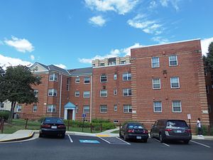
Lee Gardens North Historic District
Historic district in Virginia, United States
Distance: Approx. 398 meters
Latitude and longitude: 38.88555556,-77.08666667
The Lee Gardens North Historic District, also known as Woodbury Park Apartments, is a national historic district located at Arlington County, Virginia. It contains thirty attached masonry structures forming seven contributing buildings in a residential neighborhood in north Arlington. The garden apartment complex was designed by architect Mihran Mesrobian according to the original standards promoted by the Federal Housing Administration (FHA).
Little Saigon, Arlington, Virginia
Neighborhood in Arlington, Virginia
Distance: Approx. 178 meters
Latitude and longitude: 38.88665,-77.09315
Little Saigon is the Vietnamese ethnic enclave in the Clarendon neighborhood of Arlington, Virginia, which served the large refugee population that immigrated after the Fall of Saigon on April 30, 1975. One of many Little Saigons in the U.S., this neighborhood near Washington, D.C., became a hub of Vietnamese commerce and social activity, and reached its peak during the late 1970s to the early 1980s. The opening of the Clarendon station on the Washington Metro's Orange Line led to new development and higher rents; many businesses closed or moved, notably to the nearby Eden Center.
Weather in this IP's area
clear sky
8 Celsius
8 Celsius
5 Celsius
9 Celsius
1029 hPa
88 %
1029 hPa
1021 hPa
10000 meters
07:23:08
18:22:40