205.173.24.40 - IP Lookup: Free IP Address Lookup, Postal Code Lookup, IP Location Lookup, IP ASN, Public IP
Country:
Region:
City:
Location:
Time Zone:
Postal Code:
IP information under different IP Channel
ip-api
Country
Region
City
ASN
Time Zone
ISP
Blacklist
Proxy
Latitude
Longitude
Postal
Route
Luminati
Country
ASN
Time Zone
America/Chicago
ISP
AS-EATONV
Latitude
Longitude
Postal
IPinfo
Country
Region
City
ASN
Time Zone
ISP
Blacklist
Proxy
Latitude
Longitude
Postal
Route
IP2Location
205.173.24.40Country
Region
massachusetts
City
boston
Time Zone
America/New_York
ISP
Language
User-Agent
Latitude
Longitude
Postal
db-ip
Country
Region
City
ASN
Time Zone
ISP
Blacklist
Proxy
Latitude
Longitude
Postal
Route
ipdata
Country
Region
City
ASN
Time Zone
ISP
Blacklist
Proxy
Latitude
Longitude
Postal
Route
Popular places and events near this IP address

Great Molasses Flood
1919 accident in Massachusetts, United States
Distance: Approx. 105 meters
Latitude and longitude: 42.3685,-71.05588889
The Great Molasses Flood, also known as the Boston Molasses Disaster, was a disaster that occurred on Wednesday, January 15, 1919, in the North End neighborhood of Boston, Massachusetts. A large storage tank filled with 2.3 million U.S. gallons (8,700 cubic meters) of molasses, weighing approximately 13,000 short tons (12,000 metric tons) burst, and the resultant wave of molasses rushed through the streets at an estimated 35 miles per hour (56 kilometers per hour), killing 21 people and injuring 150. The event entered local folklore and residents reported for decades afterwards that the area still smelled of molasses on hot summer days.

Great Brink's Robbery
1950 security company robbery
Distance: Approx. 239 meters
Latitude and longitude: 42.3672,-71.0575
The Great Brink's Robbery was an armed robbery of the Brink's building in the North End of Boston, Massachusetts, on January 17, 1950. The $2.775 million ($35.1 million today) theft consisted of $1,218,211.29 in cash and $1,557,183.83 in checks, money orders, and other securities. It was at the time the largest robbery in the history of the United States and has been called "the crime of the century".

Old North Church
Historic church in Massachusetts, United States
Distance: Approx. 182 meters
Latitude and longitude: 42.36638889,-71.05444444
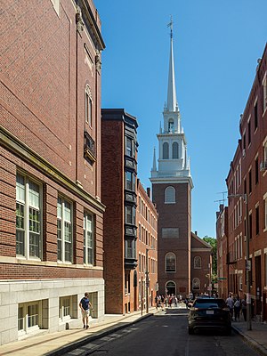
The Old North Church (officially, Christ Church in the City of Boston), is an Episcopal mission church located in the North End neighborhood of Boston. The church, which was built in 1723, is the oldest standing church building in Boston and a National Historic Landmark. Old North Church is famous for its role in Paul Revere's midnight ride on April 18, 1775.

Skinny House (Boston)
House in Boston, Massachusetts
Distance: Approx. 168 meters
Latitude and longitude: 42.366907,-71.056212
The Skinny House is an extremely narrow four-story house at 44 Hull Street in the North End of Boston, Massachusetts, United States. It is reported by the Boston Globe as having the "uncontested distinction of being the narrowest house in Boston." According to the executive director of the Boston Landmarks Commission, "In a city where there are many narrow lots, this far exceeds the norm. ...

Copp's Hill Burying Ground
Historic cemetery in Boston, Massachusetts
Distance: Approx. 157 meters
Latitude and longitude: 42.36722222,-71.05638889
Copp's Hill Burying Ground is a historic cemetery in the North End of Boston, Massachusetts. Established in 1659, it was originally named "North Burying Ground", and was the city's second cemetery.

Copp's Hill Terrace
United States historic place
Distance: Approx. 57 meters
Latitude and longitude: 42.36781111,-71.05545
Copp's Hill Terrace is a historic terrace and park between Commercial and Charter Streets west of Jackson Avenue on Copp's Hill in the North End of Boston, Massachusetts near Copp's Hill Burying Ground. Designed and built in the 1890s, it is the only public park designed for the city by the noted landscape architect Charles Eliot, and one of the few larger public spaces in the densely-built North End. It was added to the National Register of Historic Places in 1990.

Ozias Goodwin House
Historic house in Massachusetts, United States
Distance: Approx. 42 meters
Latitude and longitude: 42.36766667,-71.05502778
The Ozias Goodwin House is a historic house at 7 Jackson Avenue in the North End of Boston, Massachusetts. It is a two-story brick rowhouse, three bays wide, with brownstone window sills and lintels. The second floor windows are set just below the eave, a typical Federal period detail.

North Terminal Garage
United States historic place
Distance: Approx. 272 meters
Latitude and longitude: 42.36694444,-71.05777778
The North Terminal Garage is a historic parking garage on 600 Commercial Street in the North End of Boston, Massachusetts. The three-story concrete garage was built in 1925 to a design by Little & Russell. It is a rare surviving parking facility from such an early date, and is further notable as the site of the Great Brink's Robbery on January 17, 1950.
Coast Guard Base Boston
United States Coast Guard station in Boston, Massachusetts
Distance: Approx. 191 meters
Latitude and longitude: 42.36777778,-71.0525
United States Coast Guard Base Boston is located in the North End, Boston, Massachusetts. It is home to a number of cutters, USCGC Marlin (WPB-87304), USCGC Pendant (WYTL-65608) and soon to host 6 new Fast Response Cutters, along with other small fleet units. The small boat station located on the base was re-opened in 2003 after being closed in 1996.

Langone Park
Park in Boston, Massachusetts
Distance: Approx. 112 meters
Latitude and longitude: 42.3686,-71.0559
Langone Park is a waterfront park in the North End of Boston, Massachusetts. Established in 1973, it is named for Massachusetts state senator Joseph A. Langone, Jr. and his wife Clementina Langone.

Old North Memorial Garden
Memorial garden in Boston, Massachusetts, U.S.
Distance: Approx. 207 meters
Latitude and longitude: 42.36619,-71.05424
The Old North Memorial Garden is a garden outside the Old North Church in Boston's North End neighborhood, in the U.S. state of Massachusetts.

Paul Revere Mall
Corridor in Boston, Massachusetts, U.S.
Distance: Approx. 260 meters
Latitude and longitude: 42.36583333,-71.05361111
Paul Revere Mall is a corridor in Boston's North End, in the U.S. state of Massachusetts.
Weather in this IP's area
clear sky
-2 Celsius
-2 Celsius
-4 Celsius
-1 Celsius
1031 hPa
79 %
1031 hPa
1031 hPa
10000 meters
0.56 m/s
0.62 m/s
326 degree
8 %
