205.159.103.12 - IP Lookup: Free IP Address Lookup, Postal Code Lookup, IP Location Lookup, IP ASN, Public IP
Country:
 USA
USARegion:
City:
Location:
Time Zone:
Postal Code:
ISP:
ASN:
language:
User-Agent:
Proxy IP:
Blacklist:
IP information under different IP Channel
ip-api
Country
Region
City
ASN
Time Zone
ISP
Blacklist
Proxy
Latitude
Longitude
Postal
Route
db-ip
Country
Region
City
ASN
Time Zone
ISP
Blacklist
Proxy
Latitude
Longitude
Postal
Route
IPinfo
Country
Region
City
ASN
Time Zone
ISP
Blacklist
Proxy
Latitude
Longitude
Postal
Route
IP2Location
205.159.103.12Country
usRegion
district of columbia
City
washington
Time Zone
America/New_York
ISP
Language
User-Agent
Latitude
Longitude
Postal
ipdata
Country
Region
City
ASN
Time Zone
ISP
Blacklist
Proxy
Latitude
Longitude
Postal
Route
Popular places and events near this IP address

Columbia Heights station
Washington Metro station
Distance: Approx. 513 meters
Latitude and longitude: 38.928718,-77.032442
Columbia Heights station is a Washington Metro station in Washington, D.C., on the Green Line. Due to successful redevelopment since the station's opening, Columbia Heights is one of the busiest Metro stops outside the downtown core, with over four million exits in 2010. The station is located in Northwest Washington at 14th and Irving Streets (entrances at both the Southwest and Northeast corners), serving both the Columbia Heights and Mount Pleasant neighborhoods.

Tivoli Theatre (Washington, D.C.)
United States historic place
Distance: Approx. 322 meters
Latitude and longitude: 38.93080556,-77.03238889
The Tivoli Theatre is a landmark building in the Columbia Heights neighborhood of Washington, D.C., on 14th Street and Park Road Northwest. Originally built as a movie theater, it currently (as of 2006) exhibits live stage productions as the home of the GALA Hispanic Theatre.

HacDC
American nonprofit organization
Distance: Approx. 541 meters
Latitude and longitude: 38.93313611,-77.03592778
HacDC is a hackerspace in Washington, D.C., and a 501(c)(3) nonprofit. According to one member's description, "HacDC members improve the world by creatively rethinking technology. We break, build, and occasionally abuse technology in the pursuit of greater knowledge about how it works and re-purpose it to build new things." In March 2009, its activities were described by The Washington Post.

DC USA
Shopping mall in D.C., United States
Distance: Approx. 519 meters
Latitude and longitude: 38.92934,-77.03371
DC USA is an 890,000-square-foot (83,000 m2) vertical power center, i.e. a multilevel enclosed urban shopping center anchored by big box stores. It is located in the Columbia Heights neighborhood of Washington, D.C. A Washington City Paper poll named DC USA the "Best Designed Retail Space" of 2009.

Hilltop Manor (The Cavalier Apartment Building)
United States historic place
Distance: Approx. 365 meters
Latitude and longitude: 38.93460556,-77.03321667
Hilltop Manor, now known as The Cavalier, is an historic structure located in the Columbia Heights neighborhood in the Northwest Quadrant of Washington, D.C. This building is one of several developments between architect Harvey H. Warwick and developer Morris Cafritz, and is one of the first cooperative apartment buildings in the city. The building was opened in 1927 along the 14th Street streetcar line. Its size and density shows the rapid growth Washington experienced along major thoroughfares after World War I. It was listed on the National Register of Historic Places in 2007.

BloomBars
Distance: Approx. 325 meters
Latitude and longitude: 38.93019444,-77.028
BloomBars is a not-for-profit community arts organization based in the Columbia Heights neighborhood of Washington, D.C. Launched in June 2008 out of a former print shop at 3222 11th Street NW by John Chambers, the space currently hosts dance and wellness classes, film screenings, an open mic night, art exhibitions/performances and facilitates an artist residency program.

Riggs–Tompkins Building
United States historic place
Distance: Approx. 383 meters
Latitude and longitude: 38.93055556,-77.03305556
The Riggs–Tompkins Building is an historic structure located in the Columbia Heights neighborhood of Washington, D.C. George N. Ray designed the building that was completed in 1922. It has been listed on the District of Columbia Inventory of Historic Sites since 1985 and it was listed on the National Register of Historic Places in 1987.

Tenth Precinct Station House
United States historic place
Distance: Approx. 403 meters
Latitude and longitude: 38.93166667,-77.02527778
The Tenth Precinct Station House is an historic structure located in the Park View neighborhood of Washington, D.C. United States. The building was designed by the architectural firm of A.B. Mullett & Co. and was completed in 1905.

Park Road Courts
United States historic place
Distance: Approx. 317 meters
Latitude and longitude: 38.93027778,-77.03138889
Park Road Courts is an apartment building and an historic structure located in the Columbia Heights neighborhood in Washington, D.C. It is three-story brick building built on a raised basement. The architectural firm of Hunter & Bell designed the structure that was completed in 1916. It was listed on the National Register of Historic Places in 2012.

St. Stephen and the Incarnation Episcopal Church
Church in DC, United States
Distance: Approx. 535 meters
Latitude and longitude: 38.93328,-77.03584883
St. Stephen and the Incarnation is an Episcopal parish in the Mount Pleasant neighborhood of Washington, D.C. It was formed by the merger of St. Stephen's parish and the Church of the Incarnation.
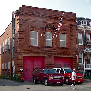
Truck Company F
United States historic place
Distance: Approx. 328 meters
Latitude and longitude: 38.93027778,-77.03166667
Truck Company F, at 1336-1338 Park Rd. NW in Washington, D.C., was built in 1900. It was listed on the National Register of Historic Places in 2007.

Blanche Kelso Bruce Elementary School
United States historic place
Distance: Approx. 496 meters
Latitude and longitude: 38.92972222,-77.02555556
The Blanche K. Bruce School was an all-black school and community center during the Jim Crow era in the United States. In July 1898, the District of Columbia public school trustees ordered that a then new public school building on Marshall Street be named the Bruce School in his honor. The Bruce School building was designed by architect William M. Poindexter in Renaissance Revival style of red brick with stone and pressed metal trim, with two floors of four rooms each.
Weather in this IP's area
clear sky
10 Celsius
8 Celsius
9 Celsius
11 Celsius
1021 hPa
36 %
1021 hPa
1012 hPa
10000 meters
7.2 m/s
10.8 m/s
300 degree