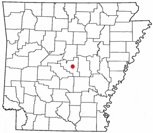
Country:
Region:
City:
Latitude and Longitude:
Time Zone:
Postal Code:
IP information under different IP Channel
ip-api
Country
Region
City
ASN
Time Zone
ISP
Blacklist
Proxy
Latitude
Longitude
Postal
Route
Luminati
Country
Region
ar
City
maumelle
ASN
Time Zone
America/Chicago
ISP
DISNW1
Latitude
Longitude
Postal
IPinfo
Country
Region
City
ASN
Time Zone
ISP
Blacklist
Proxy
Latitude
Longitude
Postal
Route
db-ip
Country
Region
City
ASN
Time Zone
ISP
Blacklist
Proxy
Latitude
Longitude
Postal
Route
ipdata
Country
Region
City
ASN
Time Zone
ISP
Blacklist
Proxy
Latitude
Longitude
Postal
Route
Popular places and events near this IP address

Maumelle, Arkansas
City in Arkansas, United States
Distance: Approx. 3217 meters
Latitude and longitude: 34.85222222,-92.37388889
Maumelle is a city in Pulaski County, Arkansas, United States. As of the 2020 census, the city's population was 19,251. The city is located northwest of Little Rock, bordering the opposite shore of the Arkansas River and is part of the Little Rock metropolitan area.
Central Arkansas Christian Schools
School in North Little Rock, Pulaski County, Arkansas, United States
Distance: Approx. 7293 meters
Latitude and longitude: 34.81527778,-92.355
Central Arkansas Christian Schools (CAC) is a group of three private schools based in North Little Rock, Arkansas, United States. CAC was established in 1971 at Sylvan Hills Church of Christ in Sherwood, Arkansas. Because of its foundation date, the school has been categorized as a segregation academy although enrollment records indicate black students were enrolled in the school as early as 1974.
Arkansas statistical areas
Distance: Approx. 4612 meters
Latitude and longitude: 34.8938,-92.4426
The U.S. State of Arkansas currently has 25 statistical areas that have been delineated by the Office of Management and Budget (OMB). On July 21, 2023, the OMB delineated four combined statistical areas, seven metropolitan statistical areas, and 14 micropolitan statistical areas in Arkansas. As of 2023, the most populous statistical area in the state is Little Rock-North Little Rock, AR CSA, comprising the metro area of its capital and largest city, Little Rock.

Arkansas River Trail
Recreational rail trail in Arkansas, United States
Distance: Approx. 5915 meters
Latitude and longitude: 34.90705556,-92.44658333
The Arkansas River Trail is a rail trail that runs 17 miles (27 km) in along both sides of the Arkansas River in Central Arkansas.
Marche, Arkansas
Unincorporated community in Arkansas, United States
Distance: Approx. 3837 meters
Latitude and longitude: 34.86333333,-92.3625
Marche (sometimes also called Warren) is an unincorporated community in Pulaski County, Arkansas, United States. It lies 12 miles (19 km) north of Little Rock.
Maumelle High School
Public secondary school in Maumelle, Arkansas, United States
Distance: Approx. 1811 meters
Latitude and longitude: 34.86222222,-92.38527778
Maumelle High School is a public secondary school located in Maumelle, Arkansas, United States, for students in grades nine through twelve. Maumelle is one of four high schools administered by the Pulaski County Special School District and is fed into by Maumelle Middle School. In addition to Maumelle it serves Crystal Hill.
Immaculate Heart of Mary Church (North Little Rock, Arkansas)
Historic church in Arkansas, United States
Distance: Approx. 5775 meters
Latitude and longitude: 34.87666667,-92.34222222
The Immaculate Heart of Mary Church is a historic Roman Catholic church in northern Pulaski County, Arkansas. It is located off Arkansas Highway 365 on Blue Hill (Jasna Gora) in Marche, north of North Little Rock.
Academics Plus Charter Schools
School district in Arkansas
Distance: Approx. 179 meters
Latitude and longitude: 34.8653,-92.405
Academics Plus Charter Schools ('APCS) is an open-enrollment public charter school system in the Little Rock metropolitan area, United States; the Academics Plus Charter School District maintains its headquarters in Maumelle. It consists of four schools: Scott Charter School in Scott and Maumelle Charter Elementary School, Maumelle Charter High School, and "Maumelle Charter Middle School" all in Maumelle. Academics Plus was chartered in 2001 as the first charter school in Arkansas.
Immaculate Heart of Mary School (Marche, Arkansas)
United States historic place
Distance: Approx. 5910 meters
Latitude and longitude: 34.8766,-92.3407
The Immaculate Heart of Mary School is a historic school building on the campus of the Immaculate Heart of Mary Church in northern Pulaski County, Arkansas. It is located off Arkansas Highway 365, north of North Little Rock and east of Marche. The building is a single-story wood-frame building with Craftsman styling.
Maumelle Ordnance Works Bunker No. 4
United States historic place
Distance: Approx. 1578 meters
Latitude and longitude: 34.85444444,-92.41277778
The Maumelle Ordnance Works Bunker No. 4 is a historic munitions storage facility at 4 Willastein Drive in Maumelle, Arkansas. It is a concrete structure, 61 by 27 feet (18.6 m × 8.2 m), with a rounded roof and ventilation stack.
Palarm Bayou Pioneer Cemetery
Historic Cemetery in Pulaski County, Arkansas, US
Distance: Approx. 4935 meters
Latitude and longitude: 34.90027778,-92.43972222
The Palarm Bayou Pioneer Cemetery is a historic cemetery in a rural-suburban area of northern Pulaski County, Arkansas. It is located northwest of Maumelle, between the Arkansas River Trail (Arkansas Highway 365) and Palarm Creek, on a rise that is now part of the gated Mountain Crest residential subdivision. The small cemetery, with just ten marked graves, stands at the top of a rise north of Mt.
Pyeatte-Mason Cemetery
Historic cemetery in Arkansas, United States
Distance: Approx. 2156 meters
Latitude and longitude: 34.85194444,-92.41944444
The Pyeatte-Mason Cemetery is a small historic cemetery at the junction of Waterside and Lily Streets on the west side of Maumelle, Arkansas. It occupies a small wooded lot, and has ten marked graves. It contains graves of some of Pulaski County's earliest settlers, the Pyeatte and Carnahan families.
Weather in this IP's area
overcast clouds
11 Celsius
11 Celsius
9 Celsius
12 Celsius
1015 hPa
87 %
1015 hPa
1003 hPa
10000 meters
0.89 m/s
2.24 m/s
194 degree
86 %
06:45:27
17:03:49


