205.142.14.36 - IP Lookup: Free IP Address Lookup, Postal Code Lookup, IP Location Lookup, IP ASN, Public IP
Country:
Region:
City:
Location:
Time Zone:
Postal Code:
IP information under different IP Channel
ip-api
Country
Region
City
ASN
Time Zone
ISP
Blacklist
Proxy
Latitude
Longitude
Postal
Route
Luminati
Country
Region
ut
City
westvalleycity
ASN
Time Zone
America/Denver
ISP
AFSTORES-AS
Latitude
Longitude
Postal
IPinfo
Country
Region
City
ASN
Time Zone
ISP
Blacklist
Proxy
Latitude
Longitude
Postal
Route
IP2Location
205.142.14.36Country
Region
utah
City
salt lake city
Time Zone
America/Denver
ISP
Language
User-Agent
Latitude
Longitude
Postal
db-ip
Country
Region
City
ASN
Time Zone
ISP
Blacklist
Proxy
Latitude
Longitude
Postal
Route
ipdata
Country
Region
City
ASN
Time Zone
ISP
Blacklist
Proxy
Latitude
Longitude
Postal
Route
Popular places and events near this IP address

Salt Lake Valley
Geographic depression in northern Utah, US, containing Salt Lake City and its suburbs
Distance: Approx. 2651 meters
Latitude and longitude: 40.6839,-111.978
Salt Lake Valley is a 500-square-mile (1,300 km2) valley in Salt Lake County in the north-central portion of the U.S. state of Utah. It contains Salt Lake City and many of its suburbs, notably Murray, Sandy, South Jordan, West Jordan, and West Valley City; its total population is 1,029,655 as of 2010. Brigham Young said, "this is the right place," when he and his fellow Mormon settlers moved into Utah after being driven out of several states.
Salt Lake Community College
Public college in Salt Lake County, Utah, US
Distance: Approx. 2451 meters
Latitude and longitude: 40.67222222,-111.94444444
Salt Lake Community College (SLCC) is a public community college in Salt Lake County, Utah. It is the state's largest two-year college with the most diverse student body. It serves amlost 50,000 students on 8 campuses as well as through online classes.

Maverik Center
Multi-purpose indoor arena in West Valley City, Utah, U.S.
Distance: Approx. 985 meters
Latitude and longitude: 40.70272222,-111.95041667
The Maverik Center, originally known as the E Center, is a 12,600-seat multi-purpose indoor arena located in West Valley City, Utah, United States. Construction on the arena started in 1996 and was completed in time to hold its first event on September 22, 1997. The arena is owned by West Valley City, and managed by Centennial Management Group.

Granger High School (Utah)
Free public school in West Valley City, Utah, United States
Distance: Approx. 2460 meters
Latitude and longitude: 40.695,-111.97861111
Granger High School is a public high school located in West Valley City, Utah, United States. The school enrollment for the 2019–20 school year was 3,155 with 123 teachers, for a teacher to student ratio of 25.64. The mascot is the Granger Lancer.
Valley Fair Mall (Utah)
Shopping mall in West Valley City, Utah
Distance: Approx. 515 meters
Latitude and longitude: 40.69444444,-111.95555556
Valley Fair Mall is a 831,667-square-foot (77,264.4 m2) single-level regional shopping center located in West Valley City, Utah, United States. Anchor stores are All Star Bowling & Entertainment, Hobby Lobby, JCPenney, Megaplex Theatres, Old Navy, Ross Dress For Less, and Ulta Beauty.

KKAT (AM)
Radio station in Salt Lake City, Utah
Distance: Approx. 2624 meters
Latitude and longitude: 40.71305556,-111.93138889
KKAT (860 kHz) is an AM radio station broadcasting a talk radio format. KKAT is licensed to Salt Lake City, Utah and is owned by Cumulus Media. The station's studios are located in South Salt Lake (behind the I-15/I-80 interchange).
West Lake Junior High
Public jr. high school in West Valley City, Salt Lake County, Utah, USA
Distance: Approx. 2185 meters
Latitude and longitude: 40.69916667,-111.97444444
West Lake STEM Junior High or WLJH is a public junior high in West Valley City, Utah. It is located at 3400 South and 3450 West in the Granger region of West Valley City. The school belongs to the very large Granite School District, which covers a large portion of the Salt Lake Valley in Utah.

Redwood Junction station
Light rail station in West Valley City, Utah, United States
Distance: Approx. 2063 meters
Latitude and longitude: 40.711091,-111.940362
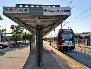
Redwood Junction station is a light rail station in West Valley City, Utah, United States, served by the Green Line of the Utah Transit Authority's (UTA) TRAX light rail system. The Green Line provides service from the Salt Lake International Airport to West Valley City (via Downtown Salt Lake City).

West Valley Central station
Light rail station in Utah
Distance: Approx. 812 meters
Latitude and longitude: 40.6944,-111.9591
West Valley Central station (also called the West Valley Intermodal Hub) is a light rail station in West Valley City, Utah served by the Green Line of the Utah Transit Authority's (UTA) TRAX light rail system. The Green Line provides service from the Salt Lake City International Airport to this station (via Downtown Salt Lake City).

Decker Lake station
Light rail station in West Valley, Utah, United States
Distance: Approx. 1199 meters
Latitude and longitude: 40.704656,-111.948688
Decker Lake station is a light rail station in West Valley City, Utah, served by the Green Line of the Utah Transit Authority's (UTA) TRAX light rail system. The Green Line provides service from the Salt Lake International Airport to West Valley City (via Downtown Salt Lake City).
Anime Salt Lake
Anime convention in Taylorsville, Utah
Distance: Approx. 2451 meters
Latitude and longitude: 40.67222222,-111.94444444
Anime Salt Lake was an anime convention held at the Salt Lake Community College (SLCC) Redwood Campus in Taylorsville, Utah, United States.

Lifetime Activities Center
Arena in Taylorsville, Utah
Distance: Approx. 2375 meters
Latitude and longitude: 40.67277778,-111.94555556
The Lifetime Activities Center is a 5,000-seat multi-purpose arena in Taylorsville, Utah, on campus of Salt Lake Community College. The arena hosts the Bruins' basketball team, and formerly the G League affiliate of the Utah Jazz, the Salt Lake City Stars. Every February through March, it hosts Utah high school girls' basketball championships.
Weather in this IP's area
overcast clouds
0 Celsius
-2 Celsius
-1 Celsius
1 Celsius
1032 hPa
65 %
1032 hPa
861 hPa
10000 meters
1.54 m/s
220 degree
100 %