204.89.196.82 - IP Lookup: Free IP Address Lookup, Postal Code Lookup, IP Location Lookup, IP ASN, Public IP
Country:
Region:
City:
Location:
Time Zone:
Postal Code:
IP information under different IP Channel
ip-api
Country
Region
City
ASN
Time Zone
ISP
Blacklist
Proxy
Latitude
Longitude
Postal
Route
Luminati
Country
ASN
Time Zone
America/Toronto
ISP
QUESTADE
Latitude
Longitude
Postal
IPinfo
Country
Region
City
ASN
Time Zone
ISP
Blacklist
Proxy
Latitude
Longitude
Postal
Route
IP2Location
204.89.196.82Country
Region
ontario
City
toronto
Time Zone
America/Toronto
ISP
Language
User-Agent
Latitude
Longitude
Postal
db-ip
Country
Region
City
ASN
Time Zone
ISP
Blacklist
Proxy
Latitude
Longitude
Postal
Route
ipdata
Country
Region
City
ASN
Time Zone
ISP
Blacklist
Proxy
Latitude
Longitude
Postal
Route
Popular places and events near this IP address

Newtonbrook
Neighbourhood of Toronto
Distance: Approx. 401 meters
Latitude and longitude: 43.78333333,-79.41666667
Newtonbrook is a neighbourhood in Toronto, Ontario, Canada. It is located in the area around Yonge Street and Finch Avenue in the district of North York between the east and west branches of the Don River. Officially, the area is divided into two neighbourhoods; Newtonbrook West and Newtonbrook East.

Finch station
Toronto subway station
Distance: Approx. 177 meters
Latitude and longitude: 43.78138889,-79.41583333
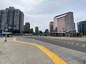
Finch is the northern terminus subway station of the eastern section of Line 1 Yonge–University in Toronto, Ontario, Canada. It is located under Yonge Street, north of Finch Avenue. Finch is the busiest TTC bus terminal and the sixth-busiest subway station, serving approximately 70,775 people per day.

Willowdale (federal electoral district)
Federal electoral district in Ontario, Canada
Distance: Approx. 202 meters
Latitude and longitude: 43.778,-79.416
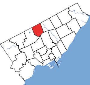
Willowdale is a federal electoral district in Toronto, Ontario, Canada. It has been represented in the House of Commons of Canada since 1979. It is the riding with the biggest Korean community in Canada.
John Finch's Hotel
Distance: Approx. 185 meters
Latitude and longitude: 43.781087,-79.414244
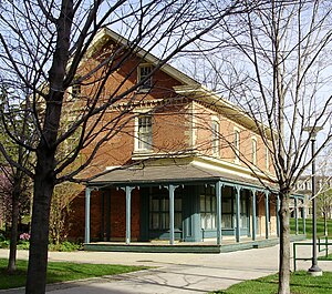
Finch Hotel was an inn located in current-day Toronto, Ontario, Canada. It was opened in 1848 by John Finch on Lot # 2, Concession # 1, with a land size of 200 acres (81 ha). Before Finch's takeover, the inn was owned by Thomas Johnson from the late 1790s.

Finch Bus Terminal
Bus terminal in Toronto, Ontario, Canada
Distance: Approx. 270 meters
Latitude and longitude: 43.78222222,-79.41555556
Finch GO Bus Terminal is a bus terminal in Toronto, Ontario, Canada. It serves to connect the transit services of York Region to the north and the transit services of Toronto. It is located at 5697 Yonge Street on the northeast corner of Bishop Avenue and Yonge Street, one block north of Finch Avenue, connected by tunnel to Finch subway station.

Gibson House
Historic house museum in Toronto, Ontario
Distance: Approx. 1140 meters
Latitude and longitude: 43.76958333,-79.41472222
Gibson House is a historical museum in Toronto, Ontario, Canada. It is located on Yonge Street, in the North York Centre neighbourhood of the former city of North York.

Dempsey Store
Distance: Approx. 1087 meters
Latitude and longitude: 43.770079,-79.416966
Dempsey Store was a hardware store built in 1860 at the northwest corner of Yonge Street and Sheppard Avenue, in North York, Toronto, Ontario, Canada. The historic store was moved and restored as a historic site further north at 250 Beecroft Road in 1996. The site in Dempsey Park is maintained by the Toronto Parks, Forestry and Recreation Division and the North York Historical Society.

Conseil scolaire catholique MonAvenir
Board of education
Distance: Approx. 906 meters
Latitude and longitude: 43.786,-79.423
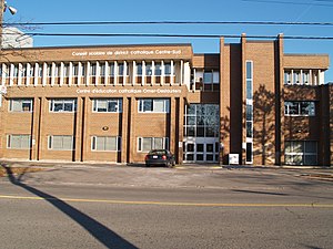
Conseil scolaire catholique MonAvenir (also referred to as Csc MonAvenir) is a French-language Catholic school board that manages elementary and secondary French schools in South-Central Ontario. The school board operates 47 elementary schools, 12 secondary schools, and two combined institutions within that area; in all major cities, including throughout the GTA. Conseil scolaire catholique MonAvenir is headquartered in the Centre d'éducation catholique Omer-Deslauriers (Omer Deslauriers Centre of Catholic Education) in Toronto, Ontario, Canada. The school board was formed in 1998 after several local school boards were amalgamated into the French-language Separate District School Board No.

Willowdale (provincial electoral district)
Provincial electoral district in Ontario, Canada
Distance: Approx. 202 meters
Latitude and longitude: 43.778,-79.416
Willowdale is a provincial electoral district in Toronto, Ontario, Canada. It elects one member to the Legislative Assembly of Ontario. It was created in 1987.

École secondaire catholique Monseigneur-de-Charbonnel
Bill 30 catholic high school in North York, Toronto, Ontario, Canada
Distance: Approx. 906 meters
Latitude and longitude: 43.786,-79.423
École secondaire catholique Monseigneur-de-Charbonnel (occasionally called ESCMDC, ESC Charbonnel, or Charbonnel); known in English as Monsignor Charbonnel Catholic Secondary School is a French-language Catholic elementary and high school operated by the Conseil scolaire de district catholique Centre-Sud (CSDCCS) in the North York district of Toronto, Ontario, Canada. It was part of Le Conseil des écoles catholiques du Grand Toronto (the Metropolitan Separate School Board) as the only French secondary school until 1998 when the board became the Toronto Catholic District School Board and its schools for francophones were transferred to the Conseil scolaire de district catholique Centre-Sud. Located at the North York Board of Education's former Lewis S. Beattie Secondary School, the school is attached by the offices of CSDCCS. The school was named after Armand-François-Marie de Charbonnel, who was the Roman Catholic Bishop of Toronto from 1847 to 1860.
Drewry Secondary School
Public high school in Toronto, Ontario, Canada
Distance: Approx. 898 meters
Latitude and longitude: 43.7869,-79.421
Drewry Secondary School, formerly known as Lewis S. Beattie Vocational School and Lewis S. Beattie Secondary School is a small specialized vocational secondary school in Toronto, Ontario, Canada. It is located in the Newtonbrook neighborhood of the former suburb of North York. It was operated by the North York Board of Education until its merger into the Toronto District School Board.
Avondale Alternative Secondary School
Alternative public school in Toronto, Ontario, Canada
Distance: Approx. 783 meters
Latitude and longitude: 43.786261,-79.411858
Avondale Alternative Secondary School is a public alternative school in Toronto, Ontario, Canada. It teaches grades 9 through 12. ASAS and its family schools, Avondale Elementary School and Avondale Alternative Elementary School, are part of the Toronto District School Board.
Weather in this IP's area
mist
6 Celsius
3 Celsius
5 Celsius
7 Celsius
1016 hPa
92 %
1016 hPa
995 hPa
4828 meters
3.09 m/s
80 degree
