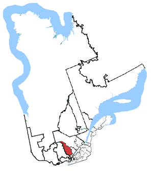
Country:
 Canada
Region:
City:
Latitude and Longitude:
Time Zone:
Postal Code:
IP information under different IP Channel
ip-api
Country
Region
City
ASN
Time Zone
ISP
Blacklist
Proxy
Latitude
Longitude
Postal
Route
IPinfo
Country
Region
City
ASN
Time Zone
ISP
Blacklist
Proxy
Latitude
Longitude
Postal
Route
MaxMind
Country
Region
City
ASN
Time Zone
ISP
Blacklist
Proxy
Latitude
Longitude
Postal
Route
Luminati
Country
CARegion
qc
City
crabtree
ASN
Time Zone
America/Toronto
ISP
SATLCMINT01
Latitude
Longitude
Postal
db-ip
Country
Region
City
ASN
Time Zone
ISP
Blacklist
Proxy
Latitude
Longitude
Postal
Route
ipdata
Country
Region
City
ASN
Time Zone
ISP
Blacklist
Proxy
Latitude
Longitude
Postal
Route
Popular places and events near this IP address
Joliette (federal electoral district)
Federal electoral district in Quebec, Canada
Distance: Approx. 4971 meters
Latitude and longitude: 46.654,-73.962
Joliette is a federal electoral district in Quebec, Canada, that has been represented in the House of Commons of Canada from 1867 to 1935 and since 1968.
Lac Kaiagamac Water Aerodrome
Airport in Lac Kaiagamac, Quebec
Distance: Approx. 3918 meters
Latitude and longitude: 46.65166667,-73.895
Lac Kaiagamac Water Aerodrome (TC LID: CSF8) was located on Lac Kaiagamac, Quebec, Canada and was open from the middle of May until the middle of November.
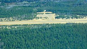
Saint-Michel-des-Saints Aerodrome
Aerodrome in Saint-Michel-des-Saints, Quebec, Canada
Distance: Approx. 6077 meters
Latitude and longitude: 46.68083333,-73.99361111
Saint-Michel-des-Saints Aerodrome (TC LID: CSM5) is located 3 nautical miles (5.6 km; 3.5 mi) west of Saint-Michel-des-Saints, Quebec, Canada.

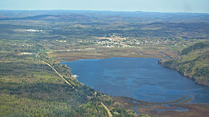
Saint-Michel-des-Saints
Municipality in Quebec, Canada
Distance: Approx. 217 meters
Latitude and longitude: 46.68333333,-73.91666667
Saint-Michel-des-Saints is a municipality in the Matawinie Regional County Municipality of Quebec, Canada. Agriculture, forestry, recreation, and tourism have been the main activities found within this region.
Saint Pierre River (Mirabel)
River in Quebec, Canada
Distance: Approx. 6142 meters
Latitude and longitude: 46.73027778,-73.86972222
The Saint-Pierre River is a tributary of the Mascouche River, flowing in the sector of "Saint-Janvier", in the city of Mirabel, in the region administrative Laurentides, in the southwest of Quebec at Canada. This river runs eastwards an agricultural plain skirting the northern village of "Saint-Janvier".
Saint-Michel-des-Saints/Lac Kaiagamac Water Aerodrome
Airport in Lac Kaiagamac, Quebec
Distance: Approx. 3999 meters
Latitude and longitude: 46.65111111,-73.89416667
Saint-Michel-des-Saints/Lac Kaiagamac Water Aerodrome (TC LID: CLK4) is located on Lac Kaiagamac, 1.7 nautical miles (3.1 km; 2.0 mi) south southeast of Saint-Michel-des-Saints, Quebec, Canada.
Saint-Michel-des-Saints (Marina Le Nautique) Water Aerodrome
Airport in Taureau Reservoir, Quebec
Distance: Approx. 1349 meters
Latitude and longitude: 46.69,-73.89861111
Saint-Michel-des-Saints (Marina Le Nautique) Water Aerodrome (TC LID: CMS3) is located on Taureau Reservoir, 3 nautical miles (5.6 km; 3.5 mi) west of Saint-Michel-des-Saints, Quebec, Canada.
Weather in this IP's area
clear sky
25 Celsius
25 Celsius
25 Celsius
25 Celsius
1022 hPa
66 %
1022 hPa
978 hPa
10000 meters
2.62 m/s
6.83 m/s
258 degree
7 %
06:35:24
19:05:28