Country:
 USA
USARegion:
City:
Latitude and Longitude:
Time Zone:
Postal Code:
IP information under different IP Channel
ip-api
Country
Region
City
ASN
Time Zone
ISP
Blacklist
Proxy
Latitude
Longitude
Postal
Route
IPinfo
Country
Region
City
ASN
Time Zone
ISP
Blacklist
Proxy
Latitude
Longitude
Postal
Route
MaxMind
Country
Region
City
ASN
Time Zone
ISP
Blacklist
Proxy
Latitude
Longitude
Postal
Route
Luminati
Country
USASN
Time Zone
America/Chicago
ISP
REGISCORP
Latitude
Longitude
Postal
db-ip
Country
Region
City
ASN
Time Zone
ISP
Blacklist
Proxy
Latitude
Longitude
Postal
Route
ipdata
Country
Region
City
ASN
Time Zone
ISP
Blacklist
Proxy
Latitude
Longitude
Postal
Route
Popular places and events near this IP address

Metropolitan Building (Minneapolis)
Structure in Minneapolis, MN, USA
Distance: Approx. 233 meters
Latitude and longitude: 44.97952778,-93.26666667
The Metropolitan Building, originally known as the Northwestern Guaranty Loan Building, is considered to be one of the most architecturally significant structures in the history of Minneapolis, Minnesota. It stood from 1890 until it was torn down starting in 1961 as part of major urban renewal efforts in the city that saw about 40% of the downtown district razed and replaced with new structures. At the time, the pending destruction of the Richardsonian Romanesque building provided a catalyst for historic preservation movements in the city and across the state.
Minneapolis Aquatennial
Annual outdoor event in Minneapolis, USA
Distance: Approx. 64 meters
Latitude and longitude: 44.9773,-93.2654
The Minneapolis Aquatennial is an annual outdoor event held in the U.S. city of Minneapolis, Minnesota, during the third full week of July. Originating in 1940, overshadowing the teamster picnics "to take the minds of Minneapolis citizens off past troubles and focus all minds throughout the state on some pleasant event", the Minneapolis Aquatennial celebrates the city's famous lakes, rivers, and streams. Advertised as The Best Days of Summer the festivities initially included some 200 events over 10 days (hence Aqua-ten-ial), at one point or another including the Aqua Follies, the Xcel Energy Sand Castle Competition, the Tom Thumb Milk Carton Boat Races, the Ultimate Wireless Co-ed Beach Volleyball Tournament, a sailing regatta, a tennis invitational, the Life Time Fitness Triathlon, many parades, among them the Minnegasco Torchlight Parade, the Master of International Management presents Shakespeare in the Park, Subway Block Party and the final Target Fireworks, one of the largest in the country, much larger than the city's Fourth of July celebration.

Minneapolis City Hall
United States historic place
Distance: Approx. 64 meters
Latitude and longitude: 44.9773,-93.2654
Minneapolis City Hall and Hennepin County Courthouse (also known as the Municipal Building), designed by Long and Kees in 1888, is the main building used by the city government of Minneapolis, as well as by Hennepin County, in the U.S. state of Minnesota. The structure has served as mainly local government offices since it was built, and today the building is 60 percent occupied by the city and 40 percent occupied by the County. The building is jointly owned by the city and county and managed by the Municipal Building Commission.
Minneapolis City Council
Lawmaking body of the City of Minneapolis
Distance: Approx. 78 meters
Latitude and longitude: 44.97722222,-93.26555556
The Minneapolis City Council is the legislative branch of the city of Minneapolis in Minnesota, United States. Comprising 13 members, the council holds the authority to create and modify laws, policies, and ordinances that govern the city. Each member represents one of the 13 wards in Minneapolis, elected for a four-year term.

Government Plaza station
Light rail station in Minneapolis, Minnesota
Distance: Approx. 128 meters
Latitude and longitude: 44.9768,-93.2658
Government Plaza station is a Metro light rail station on the Blue Line and Green Line in Minneapolis, Minnesota. The station is located on 5th Street South, between 3rd and 4th Avenues South in downtown Minneapolis. This station opened on June 26, 2004, with initial light rail service in the Twin Cities.

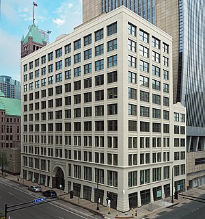
Hennepin County Government Center
Government building in Minneapolis
Distance: Approx. 255 meters
Latitude and longitude: 44.97583333,-93.26666667
Hennepin County Government Center is the courthouse and primary county government administration building for Hennepin County in the U.S. state of Minnesota. It is located in downtown Minneapolis, the county seat of Hennepin County. Before its construction, the Hennepin County government offices were housed in the Minneapolis City Hall-Hennepin County Courthouse.
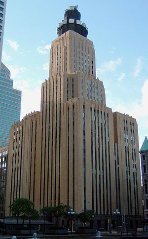
Lumen Technologies Building
American skyscraper
Distance: Approx. 135 meters
Latitude and longitude: 44.9775,-93.26666667
The Lumen Technologies Building in Minneapolis, Minnesota was completed in 1932 and became the tallest building to be built in the city during the 1930s, 1940s, and 1950s. Named for its current owner, it was previously known as the CenturyLink Building, Qwest Building and the Northwestern Bell Telephone Building. Originally standing 346 feet (105 m) tall, the structure grew to 416 feet (127 m) with the addition of a microwave antenna "crown" in 1958, followed by the addition of a second tier of microwave antennas in 1972.
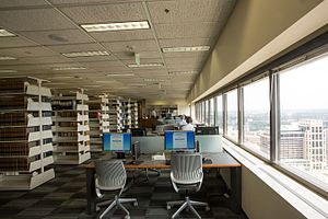
Hennepin County Law Library
Law library in Minnesota, US
Distance: Approx. 242 meters
Latitude and longitude: 44.975848,-93.266339
The Hennepin County Law Library is a law library located in Minneapolis, Minnesota, founded in 1883.

Farmers and Mechanics Savings Bank (1891)
United States historic place
Distance: Approx. 228 meters
Latitude and longitude: 44.97868333,-93.26760833
The 1891 Farmers and Mechanics Savings Bank building in Minneapolis, Minnesota, United States, is a Beaux-Arts style building that formerly served as the headquarters of Farmers and Mechanics Savings Bank. The building is now home to The Downtown Cabaret, a strip club. Architecture critic Larry Millett writes, "If you step inside for a view of the, ahem, scenery, you'll discover a glass dome that once illuminated a 'ladies banking lobby' but is now the scene of activities not everyone would consider ladylike." The building was designed by the locally prominent firm of Long and Kees as a one-story building.

U.S. Bank Plaza (Minneapolis)
Distance: Approx. 228 meters
Latitude and longitude: 44.97722222,-93.26777778
The US Bank Plaza is a two-tower high-rise building complex in Minneapolis, Minnesota. US Bank Plaza I is a 561-foot (171 m) tall, 40-floor skyscraper. US Bank Plaza II is a 321-foot (98 m) tall, 23-floor skyscraper.
Flour Exchange Building
United States historic place
Distance: Approx. 106 meters
Latitude and longitude: 44.97833333,-93.26388889
The Flour Exchange Building is an office building in downtown Minneapolis, Minnesota, United States, designed by architects Long and Kees, who also designed Minneapolis City Hall and the Lumber Exchange Building. Construction originally began in 1892, but halted abruptly in 1893 after only four floors had been built. This was due to the effects of the Panic of 1893.

United States Post Office (Minneapolis, Minnesota)
United States historic place
Distance: Approx. 240 meters
Latitude and longitude: 44.97985,-93.26404167
The United States Post Office building in Minneapolis, Minnesota, also known as the "Old" Federal Building, is a structure listed on the National Register of Historic Places. It was built from 1912 through 1915 and served as the main post office for Minneapolis until the present-day Minneapolis Post Office building was completed in 1936. Since then, it has housed a variety of federal offices.
Weather in this IP's area
clear sky
15 Celsius
14 Celsius
13 Celsius
17 Celsius
1017 hPa
54 %
1017 hPa
987 hPa
10000 meters
2.57 m/s
240 degree
07:19:00
18:42:10