204.62.22.43 - IP Lookup: Free IP Address Lookup, Postal Code Lookup, IP Location Lookup, IP ASN, Public IP
Country:
Region:
City:
Location:
Time Zone:
Postal Code:
IP information under different IP Channel
ip-api
Country
Region
City
ASN
Time Zone
ISP
Blacklist
Proxy
Latitude
Longitude
Postal
Route
Luminati
Country
Region
ok
City
oklahomacity
ASN
Time Zone
America/Chicago
ISP
OKLAHOMA-OMES
Latitude
Longitude
Postal
IPinfo
Country
Region
City
ASN
Time Zone
ISP
Blacklist
Proxy
Latitude
Longitude
Postal
Route
IP2Location
204.62.22.43Country
Region
oklahoma
City
enid
Time Zone
America/Chicago
ISP
Language
User-Agent
Latitude
Longitude
Postal
db-ip
Country
Region
City
ASN
Time Zone
ISP
Blacklist
Proxy
Latitude
Longitude
Postal
Route
ipdata
Country
Region
City
ASN
Time Zone
ISP
Blacklist
Proxy
Latitude
Longitude
Postal
Route
Popular places and events near this IP address
Enid, Oklahoma
City in Oklahoma, United States
Distance: Approx. 593 meters
Latitude and longitude: 36.40055556,-97.88083333
Enid ( EE-nid) is the ninth-largest city in the U.S. state of Oklahoma. It is the county seat of Garfield County. As of the 2020 census, the population was 51,308.

Gaslight Theatre
Distance: Approx. 385 meters
Latitude and longitude: 36.39888889,-97.87972222
The Gaslight Theatre is a nonprofit theatre troupe and venue in Enid, Oklahoma. Founded in 1966 as the Enid Community Theatre, the group stages productions of ten plays per year, including Shakespeare in the Park, musicals, and dinner theatre. Since 1989 Gaslight has called the historic Billings Theatre its home.
Enid Public Schools
School district in Oklahoma
Distance: Approx. 427 meters
Latitude and longitude: 36.391976,-97.879963
Enid Public Schools is a public school district located in Enid, Oklahoma, USA. The school district had an enrollment of 7,540 students in September 2012. The district covers central-west Enid and some unincorporated areas.

Broadway Tower (Enid, Oklahoma)
United States historic place
Distance: Approx. 159 meters
Latitude and longitude: 36.39666667,-97.87722222
The Broadway Tower, located in the Enid Downtown Historic District in Enid, Oklahoma, was constructed in 1931 by McMillen and Shelton Construction Company. The Broadway Development Company hired George Ernst von Blumenauer of Enid, and the Oklahoma City firm Layton, Hicks, and Forsythe to design the building, in the Art Deco style. In 1943, Mr.
KEIF-LP
Radio station
Distance: Approx. 57 meters
Latitude and longitude: 36.396,-97.878
KEIF-LP 104.7 FM was a low-power non-commercial community radio station in Enid, Oklahoma. It broadcast classic rock, local news and weather, and specialty programs that feature blues and novelty songs. On March 18, 2013, the FCC rescinded the station's license due to a late renewal application and previous violations.

Garfield County Courthouse (Oklahoma)
United States historic place
Distance: Approx. 156 meters
Latitude and longitude: 36.39694444,-97.87888889
The Garfield County Courthouse is a historic courthouse building located in Enid, Oklahoma. It is on the National Register of Historic Places both individually and as a part of the Enid Downtown Historic District.

Cherokee Strip Regional Heritage Center
History museum in Enid, Oklahoma, US
Distance: Approx. 649 meters
Latitude and longitude: 36.39166667,-97.87305556
The Cherokee Strip Regional Heritage Center (CSRHC) is a museum in Enid, Oklahoma, that focuses on the history of the Cherokee Outlet and the Land Run of September 16, 1893. Previously named the Museum of the Cherokee Strip, the museum has undergone renovations expanding the museum space to 24,000 square feet. The Cherokee Strip Regional Heritage Center is home to permanent and temporary exhibit galleries, a research center, and the Humphrey Heritage Village.

Enid Masonic Temple
United States historic place
Distance: Approx. 320 meters
Latitude and longitude: 36.39638,-97.88184
The Enid Masonic Temple (also known as Enid Symphony Center and the Knox Building), is a historic building in Enid, Oklahoma. It is the home of the Enid Symphony Orchestra, and was listed on the National Register of Historic Places in 1984. The Italian Renaissance Revival building is also located within the Enid Downtown Historic District which became listed on the register in 2007.

Enid station
Distance: Approx. 607 meters
Latitude and longitude: 36.39027778,-97.87694444
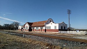
The Rock Island Depot is located in Enid, Garfield County, Oklahoma and listed on the National Register of Historic Places since 1979.
St. Mary's Regional Medical Center (Enid)
Hospital in Oklahoma, United States
Distance: Approx. 690 meters
Latitude and longitude: 36.39361111,-97.87111111
St. Mary's Regional Medical Center is a hospital located in Enid, Oklahoma.

Public Library of Enid and Garfield County
Distance: Approx. 73 meters
Latitude and longitude: 36.39583333,-97.87916667
The Public Library of Enid and Garfield County, is a public library located in Enid, Oklahoma, the county seat of Garfield County, Oklahoma.

Stride Bank Center
Multi-purpose arena in Enid, Oklahoma
Distance: Approx. 136 meters
Latitude and longitude: 36.39444444,-97.87888889
The Stride Bank Center is an arena in downtown Enid, Oklahoma.
Weather in this IP's area
mist
6 Celsius
3 Celsius
6 Celsius
6 Celsius
1015 hPa
100 %
1015 hPa
970 hPa
4023 meters
3.6 m/s
70 degree
100 %
