Country:
Region:
City:
Latitude and Longitude:
Time Zone:
Postal Code:
IP information under different IP Channel
ip-api
Country
Region
City
ASN
Time Zone
ISP
Blacklist
Proxy
Latitude
Longitude
Postal
Route
Luminati
Country
Region
va
City
fairfax
ASN
Time Zone
America/New_York
ISP
AFBA-AS
Latitude
Longitude
Postal
IPinfo
Country
Region
City
ASN
Time Zone
ISP
Blacklist
Proxy
Latitude
Longitude
Postal
Route
db-ip
Country
Region
City
ASN
Time Zone
ISP
Blacklist
Proxy
Latitude
Longitude
Postal
Route
ipdata
Country
Region
City
ASN
Time Zone
ISP
Blacklist
Proxy
Latitude
Longitude
Postal
Route
Popular places and events near this IP address

Chantilly, Virginia
CDP in Virginia, United States
Distance: Approx. 1491 meters
Latitude and longitude: 38.875,-77.4025
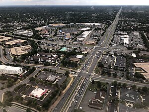
Chantilly is a census-designated place (CDP) in western Fairfax County, Virginia, United States. The population was 24,301 as of the 2020 census. Chantilly is named after an early-19th-century mansion and farm, which in turn took the name of an 18th-century plantation that was located in Westmoreland County, Virginia.

Battle of Chantilly
Battle of the American Civil War
Distance: Approx. 1760 meters
Latitude and longitude: 38.865,-77.37
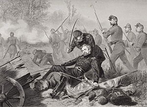
The Battle of Chantilly (or Ox Hill, the Confederate name) took place on September 1, 1862, in Fairfax County, Virginia, as the concluding battle of the Northern Virginia Campaign of the American Civil War. Thomas J. "Stonewall" Jackson's corps of the Army of Northern Virginia attempted to cut off the line of retreat of the Union Army of Virginia following the Second Battle of Bull Run but was attacked by two Union divisions. During the ensuing battle, Union division commanders Isaac Stevens and Philip Kearny were both killed, but the Union attack halted Jackson's advance.

Ox Hill Battlefield Park
Distance: Approx. 1830 meters
Latitude and longitude: 38.86451,-77.36949
Ox Hill Battlefield Park is a site in Fairfax, Virginia, where the Battle of Ox Hill (Union name Battle of Chantilly) was fought during the American Civil War. It was the only major battle of the war fought in Fairfax County. The battlefield is now a public park adjacent to suburban developments and the Fairfax Towne Center shopping center, and is maintained by the Fairfax County Park Authority.
Chantilly High School
Public high school in Virginia
Distance: Approx. 1923 meters
Latitude and longitude: 38.8805,-77.4065
Chantilly High School is a public high school in the Chantilly CDP in unincorporated Fairfax County, Virginia, United States. It is part of the Fairfax County Public Schools system.

Fair Oaks Mall
Shopping mall in Fairfax County, Virginia
Distance: Approx. 2665 meters
Latitude and longitude: 38.863,-77.359
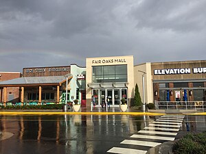
Fair Oaks Mall is a shopping mall in the Fair Oaks census-designated place (CDP) of unincorporated Fairfax County, Virginia, just northwest of the independent city of Fairfax. It is located at the intersection of Interstate 66 and U.S. Route 50. The mall has a gross leasable area (GLA) of 1,557,000 sq ft (144,700 m2).

Fair Lakes, Virginia
Census-designated place in Virginia, United States
Distance: Approx. 1405 meters
Latitude and longitude: 38.86305556,-77.38194444
Fair Lakes is a census-designated place (CDP) and business park located west of Fairfax in Fairfax County, Virginia, United States. Fair Lakes had a population of 8,404 in 2020.

Fairfax County Government Center
Government building in County of Fairfax, United States of America
Distance: Approx. 3413 meters
Latitude and longitude: 38.85404,-77.35706
The Fairfax County Government Center is the headquarters for the Fairfax County, Virginia local government. Located west of the City of Fairfax in an unincorporated area of the county, it is the meeting place of the Fairfax County Board of Supervisors and the offices for the Fairfax County Executive and their deputies.

Fair Oaks, Fairfax County, Virginia
Census-designated place in Virginia, United States
Distance: Approx. 2503 meters
Latitude and longitude: 38.86583333,-77.35916667
Fair Oaks is a census-designated place in Fairfax County, Virginia, United States. The population at the 2020 census was 34,052. It encompasses a large area west of the city of Fairfax, centered on Fair Oaks Mall.

Greenbriar, Virginia
Census-designated place in Virginia, United States
Distance: Approx. 1272 meters
Latitude and longitude: 38.87166667,-77.39916667
Greenbriar is a census-designated place in Fairfax County, Virginia, United States. The population at the 2020 census was 8,421. The community between Fairfax City and Chantilly dates from the late 1960s, when it was developed by Levitt & Sons.
Mitchell-Weeks House
Distance: Approx. 3459 meters
Latitude and longitude: 38.8896,-77.4208
The Mitchell-Weeks House is a "Potomac Valley style" log farmhouse first built in 1789. Descendants of builder Benjamin Mitchell lived in the house, located in Chantilly, Virginia just west of the intersection of Lee-Jackson Highway and Lee's Corner Road, until approximately 1940. Subsequent owners renovated and remodeled the house, but it currently preserves the Early American-era log front wall and stone chimneys.
Bull Run Formation
Geological formation in the United States
Distance: Approx. 3020 meters
Latitude and longitude: 38.9,-77.4
The Bull Run Formation is a Late Triassic (Norian) stratigraphic unit in the eastern United States. Fossil fish bones and scales have been found in outcrops of the formation's Groveton Member in Manassas National Battlefield Park. Indeterminate fossil ornithischian tracks have been reported from the formation.
Navy, Virginia
Place in Virginia
Distance: Approx. 1713 meters
Latitude and longitude: 38.88972222,-77.37805556
Navy is an unincorporated community and census designated place in Fairfax County, Virginia, United States. It first appeared as a CDP in the 2020 Census with a population of 4,327.
Weather in this IP's area
overcast clouds
9 Celsius
8 Celsius
8 Celsius
11 Celsius
1014 hPa
84 %
1014 hPa
998 hPa
10000 meters
2.06 m/s
310 degree
100 %
06:52:49
16:55:53