Country:
 USA
USARegion:
City:
Latitude and Longitude:
Time Zone:
Postal Code:
IP information under different IP Channel
ip-api
Country
Region
City
ASN
Time Zone
ISP
Blacklist
Proxy
Latitude
Longitude
Postal
Route
IPinfo
Country
Region
City
ASN
Time Zone
ISP
Blacklist
Proxy
Latitude
Longitude
Postal
Route
MaxMind
Country
Region
City
ASN
Time Zone
ISP
Blacklist
Proxy
Latitude
Longitude
Postal
Route
Luminati
Country
USRegion
nc
City
lakelure
ASN
Time Zone
America/New_York
ISP
SKYRUNNER-INC
Latitude
Longitude
Postal
db-ip
Country
Region
City
ASN
Time Zone
ISP
Blacklist
Proxy
Latitude
Longitude
Postal
Route
ipdata
Country
Region
City
ASN
Time Zone
ISP
Blacklist
Proxy
Latitude
Longitude
Postal
Route
Popular places and events near this IP address

Chimney Rock, North Carolina
Village in North Carolina, United States
Distance: Approx. 6638 meters
Latitude and longitude: 35.45027778,-82.255
Chimney Rock is a village in Rutherford County, North Carolina, United States. The population was 113 at the 2010 census. The village takes its name from a large granite outcropping located on a summit above the village itself in Chimney Rock State Park.

Lake Lure, North Carolina
Town in North Carolina, United States
Distance: Approx. 2469 meters
Latitude and longitude: 35.44027778,-82.20638889
Lake Lure is a town in Rutherford County, North Carolina, United States. In 2020 the town population was 1,634. Lake Lure was incorporated in 1927, and acquired the lake after which it is named in 1965.
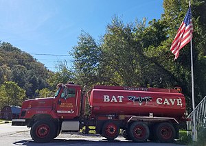
Bat Cave, North Carolina
Unincorporated community in North Carolina, United States
Distance: Approx. 9536 meters
Latitude and longitude: 35.45138889,-82.28694444
Bat Cave is an unincorporated community in Henderson County, North Carolina, United States and is part of the Asheville Metropolitan Statistical Area. Named after a bat cave located on Bluerock Mountain (also known as Bat Cave Mountain), it is the largest known augen gneiss granite fissure cave in North America and is a protected area, not open to the public. It has frequently been noted on lists of unusual place names and is also a regular victim of street sign theft, especially in the early 1990s during the popularity of the movie Batman Returns.

Chimney Rock State Park
State park in North Carolina, United States
Distance: Approx. 6508 meters
Latitude and longitude: 35.43305556,-82.25055556
Chimney Rock State Park is a North Carolina state park in Chimney Rock, Rutherford County, North Carolina in the United States. The 8,014-acre (32.43 km2) park is located 25 miles (40 km) southeast of Asheville, North Carolina, and is owned and managed by the state of North Carolina. The park features hiking trails for all skill levels, views of the Devil's Head balancing rock, and a 404-foot (123 m) waterfall, Hickory Nut Falls.
Bluerock Mountain (North Carolina)
Mountain in North Carolina, United States
Distance: Approx. 8836 meters
Latitude and longitude: 35.4375,-82.27805556
Bluerock Mountain is a mountain in Western North Carolina, near the community of Bat Cave. It is split between Henderson and Rutherford counties, it is home of the Bat Cave Preserve and part of Chimney Rock State Park. Its elevation reaches 2,835 feet (864 m).

Palmer Fire School
Historic school building in North Carolina, United States
Distance: Approx. 4509 meters
Latitude and longitude: 35.4375,-82.22916667
Palmer Fire School, also known as Firemen's Hall, is a historic school complex for firefighters located at Charlotte, Mecklenburg County, North Carolina. The complex consists of the 1940, one-story, rock-faced assembly hall and the 1938, six-story, red-brick training tower. The assembly hall is a Late Gothic Revival style building, five bays wide with a stuccoed, crenellated parapet and projecting end bays.
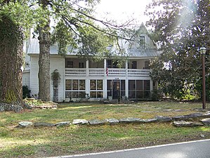
Pine Gables
Historic district in North Carolina, United States
Distance: Approx. 4509 meters
Latitude and longitude: 35.4375,-82.22916667
Pine Gables, also known as Logan House and Harris Inn, is a historic inn complex and national historic district located near Lake Lure, Rutherford County, North Carolina. The property encompasses 10 contributing buildings, 5 contributing sites, and 3 contributing structures. The original log sections of the inn dates to about 1800, and enlarged and modified in 1834, 1877, and 1924.
Weather in this IP's area
overcast clouds
27 Celsius
27 Celsius
25 Celsius
29 Celsius
1012 hPa
75 %
1012 hPa
971 hPa
10000 meters
0.89 m/s
2.24 m/s
133 degree
97 %
07:14:49
19:29:58