204.249.65.145 - IP Lookup: Free IP Address Lookup, Postal Code Lookup, IP Location Lookup, IP ASN, Public IP
Country:
Region:
City:
Location:
Time Zone:
Postal Code:
IP information under different IP Channel
ip-api
Country
Region
City
ASN
Time Zone
ISP
Blacklist
Proxy
Latitude
Longitude
Postal
Route
Luminati
Country
Region
ny
City
irving
ASN
Time Zone
America/New_York
ISP
ASN-NETSYNC
Latitude
Longitude
Postal
IPinfo
Country
Region
City
ASN
Time Zone
ISP
Blacklist
Proxy
Latitude
Longitude
Postal
Route
IP2Location
204.249.65.145Country
Region
new york
City
fredonia
Time Zone
America/New_York
ISP
Language
User-Agent
Latitude
Longitude
Postal
db-ip
Country
Region
City
ASN
Time Zone
ISP
Blacklist
Proxy
Latitude
Longitude
Postal
Route
ipdata
Country
Region
City
ASN
Time Zone
ISP
Blacklist
Proxy
Latitude
Longitude
Postal
Route
Popular places and events near this IP address
Fredonia, New York
Village in New York, United States
Distance: Approx. 1684 meters
Latitude and longitude: 42.44055556,-79.33194444
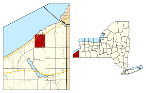
Fredonia is a village in Chautauqua County, New York, United States. The population was 9,871 as of the 2020 census. Fredonia is in the town of Pomfret south of Lake Erie.

Pomfret, New York
Town in New York, United States
Distance: Approx. 1398 meters
Latitude and longitude: 42.41722222,-79.35055556
Pomfret is a town in Chautauqua County, New York, United States. The population was 13,236 at the 2020 census. The town lies in the north-central part of the county, south of Dunkirk, and includes the village of Fredonia.

Dunkirk (town), New York
Town in New York, United States
Distance: Approx. 4226 meters
Latitude and longitude: 42.46416667,-79.3425
Dunkirk is a town in Chautauqua County, New York, United States. The population was 1,257 at the 2020 census. The town of Dunkirk is split into two sections, east and west, by the city of Dunkirk, which is a separate entity.
State University of New York at Fredonia
Public university in Fredonia, New York
Distance: Approx. 3025 meters
Latitude and longitude: 42.45344,-79.33697
The State University of New York at Fredonia (alternatively SUNY Fredonia, Fredonia State, or Fredonia) is a public university in Fredonia, New York. It is the westernmost member of the State University of New York. Founded in 1826, it is the sixty-sixth-oldest institute of higher education in the United States, seventh-oldest college in New York, and second-oldest public school in New York (SUNY and CUNY) after SUNY Potsdam (1816).
Fredonia High School (New York)
Public high school in the United States
Distance: Approx. 3365 meters
Latitude and longitude: 42.44694444,-79.30888889
Fredonia High School is a public high school in Fredonia, New York. The Fredonia Central School District owns two campuses, Wheelock and the Main Campus, but the entire student population is currently at the Main Campus due to declining enrollment. The Wheelock building housed the entire school district until there was not enough room for the large incoming classes.
Laona, New York
Hamlet in New York, United States
Distance: Approx. 2780 meters
Latitude and longitude: 42.42166667,-79.30555556
Laona is a hamlet in Chautauqua County, New York, United States, near the village of Fredonia. It is part of the town of Pomfret and New York State Route 60 passes through the hamlet. Laona is at an elevation of 850 feet (260 m) above sea level.
WCVF-FM
Radio station in Fredonia, New York
Distance: Approx. 2889 meters
Latitude and longitude: 42.45222222,-79.33722222
WCVF-FM (88.9 MHz) is a college radio station in Fredonia, New York. The station is licensed to the State University of New York at Fredonia. "CVF" stands for "Campus and Community Voice of Fredonia," the station's slogan.

Fredonia Opera House
Distance: Approx. 1711 meters
Latitude and longitude: 42.4409,-79.3323
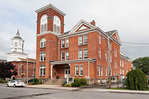
The 1891 Fredonia Opera House is located in the Village Hall, in downtown Fredonia, New York at 9-11 Church St. Currently a year-round performing arts center, it offers a variety of live performances, presents a cinema series of first run Independent and foreign films, and serves as a rental venue for community meetings, debates, weddings and performances.
United States Post Office (Fredonia, New York)
United States historic place
Distance: Approx. 1728 meters
Latitude and longitude: 42.44111111,-79.3325
US Post Office—Fredonia is a historic post office building located at Fredonia in Chautauqua County, New York, and within the boundaries of the Fredonia Commons Historic District. It was designed and built in 1935–36 as a Works Progress Administration project, and is one of a number of post offices in New York State designed by the Office of the Supervising Architect of the Treasury Department, Louis A. Simon. It is a one-story, five bay brick structure set on a brick foundation in the Colonial Revival style.

Fredonia Commons Historic District
Historic district in New York, United States
Distance: Approx. 1655 meters
Latitude and longitude: 42.44027778,-79.33194444
Fredonia Commons Historic District is a national historic district located at Fredonia in Chautauqua County, New York. The district encompasses the central core of Fredonia; the main civic buildings, churches and commercial structures clustered around the commons. The district includes approximately 25 structures including the Fenner Fire Station, Village Hall, U.S. Post Office, Darwin R. Baker Library, United Methodist Church, Baptist Church, and Trinity Episcopal Church.

The Pratt and Buckingham Octagon House
Building in Fredonia, New York
Distance: Approx. 1391 meters
Latitude and longitude: 42.43879,-79.33814
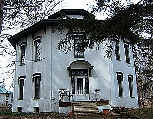
The Pratt and Buckingham Octagon House is a historic octagon house in Fredonia, Chautauqua County, New York that was built in ca. 1865. It is a private home at 99 Chestnut Street; the rear of the property is on Canadaway Creek.

Arkwright Summit Wind Farm
Wind farm in Arkwright, New York, United States
Distance: Approx. 2847 meters
Latitude and longitude: 42.436656,-79.307121
The Arkwright Summit Wind Farm is a 78.4 megawatt wind farm in Arkwright, New York. It uses 36 Vestas V110 turbines, 32 of which are rated at 2.2 megawatts and 4 of which are rated at 2.0 megawatts. The wind farm provides power for about 35,000 New York homes.
Weather in this IP's area
overcast clouds
2 Celsius
-1 Celsius
2 Celsius
3 Celsius
1030 hPa
76 %
1030 hPa
998 hPa
10000 meters
2.57 m/s
360 degree
100 %
