Country:
Region:
City:
Latitude and Longitude:
Time Zone:
Postal Code:
IP information under different IP Channel
ip-api
Country
Region
City
ASN
Time Zone
ISP
Blacklist
Proxy
Latitude
Longitude
Postal
Route
Luminati
Country
ASN
Time Zone
America/Chicago
ISP
EMERGE-AS1
Latitude
Longitude
Postal
IPinfo
Country
Region
City
ASN
Time Zone
ISP
Blacklist
Proxy
Latitude
Longitude
Postal
Route
db-ip
Country
Region
City
ASN
Time Zone
ISP
Blacklist
Proxy
Latitude
Longitude
Postal
Route
ipdata
Country
Region
City
ASN
Time Zone
ISP
Blacklist
Proxy
Latitude
Longitude
Postal
Route
Popular places and events near this IP address
Florence, Kentucky
City in Kentucky, United States
Distance: Approx. 1889 meters
Latitude and longitude: 38.99138889,-84.64611111
Florence is a city in Boone County, Kentucky, United States, part of the Cincinnati metropolitan area. The population was 31,946 at the 2020 census, making it the second-largest city in Northern Kentucky, the eighth-largest city in Kentucky and the state's largest that is not a county seat. Like all but the state's two largest cities, Florence is a home rule-class city under Kentucky state law.

Elsmere, Kentucky
City in Kentucky, United States
Distance: Approx. 2203 meters
Latitude and longitude: 38.995,-84.60166667
Elsmere is a home rule-class city in Kenton County, Kentucky, in the United States. The population was 9,159 at the 2020 census.

Boone County High School
Public secondary school in the United States
Distance: Approx. 826 meters
Latitude and longitude: 39.00553611,-84.631125
Boone County High School is located in Florence, Kentucky, United States. The school was opened in 1954, consolidating Burlington, Florence, New Haven and Hebron High Schools.

Thomas More Stadium
American sports venue
Distance: Approx. 2138 meters
Latitude and longitude: 38.982156,-84.638479
Thomas More Stadium is a stadium in Florence, Kentucky. It is primarily used for baseball and is the home field of the Florence Y'alls of the Frontier League, an independent baseball league. It originally opened in 2004 as Champion Window Field and holds 4,500 people.

Air Tahoma Flight 185
2004 aviation accident
Distance: Approx. 2056 meters
Latitude and longitude: 39.00888889,-84.64666667
Air Tahoma Flight 185 was a scheduled cargo flight from Memphis to Cincinnati/Northern Kentucky International Airport conducted by Air Tahoma as part of a contract to freight parcels for courier firm DHL. On August 13, 2004, the flight crashed during approach to landing just one mile (1.6 km) short of the runway. The Convair 580, which is a twin engine turboprop, was destroyed upon impact. The first officer was killed and the captain received minor injuries.

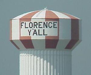
Florence Y'all Water Tower
Water tower in Florence, Kentucky, United States
Distance: Approx. 1833 meters
Latitude and longitude: 38.99766667,-84.64772222
The Florence Y'all Water Tower is a water tower owned by the city of Florence, Kentucky, United States. It stands between the Florence Mall and Interstate 75/Interstate 71, where it is seen by millions of interstate motorists annually. The tower, built in 1974 and initially painted with the words FLORENCE MALL in giant letters, became a regional landmark after the M was changed to Y' to address legal concerns.

Florence Mall (Kentucky)
Indoor shopping mall in Florence, Kentucky
Distance: Approx. 2067 meters
Latitude and longitude: 38.995825,-84.65014167
Florence Mall is an indoor shopping mall in Florence, Kentucky, United States. Built in 1976 by Homart Development Company, the mall originally featured Sears, Shillito's, Pogue's, and JCPenney as its four anchor stores. The mall features over 100 stores and a food court.

Hopeful Lutheran Church
Historic church in Kentucky, United States
Distance: Approx. 2818 meters
Latitude and longitude: 38.99944444,-84.65916667
Hopeful Lutheran Church was chartered on January 6, 1806. It was founded by a group of colonists from Virginia who settled in Boone County. In 1807, the first log church was built on an acre of donated land.

Clinton Blankenbeker House
Historic house in Kentucky, United States
Distance: Approx. 487 meters
Latitude and longitude: 38.99638889,-84.63111111
The Clinton Blankenbeker House, at 7414 US 42 in Florence, Kentucky, is a historic house built in 1927. It was listed on the National Register of Historic Places in 1989. The listing also included two other contributing buildings and a contributing structure.
Florence Fire Station
United States historic place
Distance: Approx. 206 meters
Latitude and longitude: 39.00083333,-84.62694444
The Florence Fire Station on Main Street in Florence, Kentucky was built in 1937. It was listed on the National Register of Historic Places in 1989. It was deemed "a good example of the Georgian Revival/Colonial Revival style, significant to Boone County in the period 1900-1945." It was the station of the Florence Volunteer Fire Department, organized in 1934.

John Delehunty House
United States historic place
Distance: Approx. 559 meters
Latitude and longitude: 39.00333333,-84.62333333
The John Delehunty House, at 212 Main St. in Florence, Kentucky, was a historic Tudor Revival-style house built in 1920. It was deemed significant as "a good example of the Tudor Revival style significant to Boone County in the period 1910-1940", one of just two Tudor Revival buildings in Boone County identified in a study of historic resources.
Beckfield College
Public university in Springdale, Ohio, US
Distance: Approx. 2383 meters
Latitude and longitude: 39.0171,-84.6413
Beckfield College is a private for-profit college in Florence, Kentucky. It was founded in 1984 by Harry L. Beck. It offers degree and diploma programs focused on career-oriented education such as nursing, healthcare, and business.
Weather in this IP's area
overcast clouds
9 Celsius
8 Celsius
9 Celsius
10 Celsius
1019 hPa
88 %
1019 hPa
987 hPa
10000 meters
2.57 m/s
310 degree
100 %
07:22:05
17:24:33

