204.238.24.114 - IP Lookup: Free IP Address Lookup, Postal Code Lookup, IP Location Lookup, IP ASN, Public IP
Country:
Region:
City:
Location:
Time Zone:
Postal Code:
IP information under different IP Channel
ip-api
Country
Region
City
ASN
Time Zone
ISP
Blacklist
Proxy
Latitude
Longitude
Postal
Route
Luminati
Country
ASN
Time Zone
America/Chicago
ISP
ALSK-7782
Latitude
Longitude
Postal
IPinfo
Country
Region
City
ASN
Time Zone
ISP
Blacklist
Proxy
Latitude
Longitude
Postal
Route
IP2Location
204.238.24.114Country
Region
alaska
City
juneau
Time Zone
America/Juneau
ISP
Language
User-Agent
Latitude
Longitude
Postal
db-ip
Country
Region
City
ASN
Time Zone
ISP
Blacklist
Proxy
Latitude
Longitude
Postal
Route
ipdata
Country
Region
City
ASN
Time Zone
ISP
Blacklist
Proxy
Latitude
Longitude
Postal
Route
Popular places and events near this IP address
KJNO
Radio station in Juneau, Alaska
Distance: Approx. 4366 meters
Latitude and longitude: 58.32939722,-134.473275
KJNO (630 AM) is a radio station broadcasting a news/talk/sports format. Licensed to Juneau, Alaska, United States, the station serves the Alaska Panhandle area. The station's studios are at the Juneau Radio Center, which is home to KINY, KTKU - TAKU 105, KSUP - MIX 106 and KXXJ - 1330/KXJ. The station is owned by Alaska Broadcast Communications, and features programming from CBS News Radio, and ESPN Radio.

Mendenhall Valley, Juneau
Alaskan state capitol region geographical feature
Distance: Approx. 4539 meters
Latitude and longitude: 58.39166667,-134.56666667
The Mendenhall Valley (colloquially The Valley) [Lingít: Áakʼw Táak] is the drainage area of the Mendenhall River in the U.S. state of Alaska. The valley contains a series of neighborhoods, comprising the largest populated place within the corporate limits of the City and Borough of Juneau, Alaska's capital. The valley was formed by Mendenhall Glacier over the course of roughly three thousand years.

Juneau International Airport
International airport serving Juneau, Alaska, United States
Distance: Approx. 2872 meters
Latitude and longitude: 58.355,-134.57638889
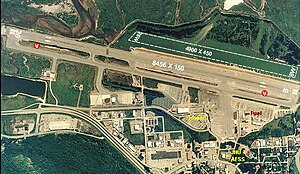
Juneau International Airport (IATA: JNU, ICAO: PAJN, FAA LID: JNU) is a city-owned, public-use airport and seaplane base located seven nautical miles (8 mi, 13 km) northwest of the central business district of Juneau, a city and borough in the U.S. state of Alaska which has no direct road access. The airport is a regional hub for all air travel, from bush carriers to major U.S. air carriers such as Alaska Airlines. The National Plan of Integrated Airport Systems for 2015-2019 categorized it as a primary commercial service (nonhub) airport based on 353,048 enplanements (boardings) in 2012.

Adair-Kennedy Memorial Park
Distance: Approx. 4125 meters
Latitude and longitude: 58.38666667,-134.56833333
Adair-Kennedy Memorial Park is a sports facility complex in Juneau, Alaska, and adjacent to Floyd Dryden Middle School. It was named after Richard James Adair and Jimmy Earl Kennedy, two Juneau Police Department officers who died in the line of duty on April 17, 1979. The park amenities include a baseball field, football/soccer field, track and a climbing structure.

Alaskan Brewing Company
Brewery in Juneau, Alaska
Distance: Approx. 2212 meters
Latitude and longitude: 58.35722222,-134.48944444
Alaskan Brewing Company is a brewery in Juneau, Alaska, founded in 1986. The company's beers have won awards at regional, national, and international beer competitions. The brewery was founded by Marcy and Geoff Larson.
KTKU
Radio station in Juneau, Alaska
Distance: Approx. 4409 meters
Latitude and longitude: 58.329,-134.473
KTKU (105.1 FM, "Taku 105") is a radio station in Juneau, Alaska. Owned by Alaska Broadcast Communications, it broadcasts a country music format. Its studios are located alongside its sister stations at 3161 Channel Drive.

Brotherhood Bridge
Bridge in Alaska, USA
Distance: Approx. 4612 meters
Latitude and longitude: 58.3704,-134.6017
The Brotherhood Bridge is a road bridge in Juneau, Alaska. The bridge carries the Glacier Highway over the Mendenhall River, acting as a demarcation point of sorts between the urban and rural portions of mainland Juneau. The bridge was named in honor of the Alaska Native Brotherhood (ANB).

Juneau Police Department
Law enforcement agency in Juneau, Alaska, United States
Distance: Approx. 1126 meters
Latitude and longitude: 58.35583333,-134.50805556
The Juneau Police Department (JPD) is a law enforcement agency which serves Juneau, Alaska. The department consists of two divisions: Administrative Support Services and Operations. Within these divisions there are five units: Patrol, Investigations, Community Service, Records and Dispatch.
Lemon Creek, Juneau
Neighborhood in Juneau, Alaska, U.S.
Distance: Approx. 1688 meters
Latitude and longitude: 58.35833333,-134.49861111
Lemon Creek (Tlingit: Eix̱'gulhéen) is a neighborhood in Juneau, Alaska, United States. It is 5 miles (8 km) northwest of downtown Juneau. It is the site of the Lemon Creek Correctional Center.
Ninemile Creek (Juneau, Alaska)
River in the United States
Distance: Approx. 3383 meters
Latitude and longitude: 58.33805556,-134.57333333
Ninemile Creek is a river on Douglas Island in the City and Borough of Juneau, Alaska, United States. Its origin is in hills to the southeast and it flows northwest to Gastineau Channel near West Juneau. It is 1.2 miles (1.9 km) east of Entrance Point and 6.4 miles (10.3 km) northwest of the city of Juneau.
Lemon Creek (Alaska)
Stream in Alaska, U.S.
Distance: Approx. 2937 meters
Latitude and longitude: 58.36416667,-134.47916667
Lemon Creek is a stream in the U.S. state of Alaska. It is primarily filled by the meltwater of Lemon Creek Glacier, as well as another glacier. The Lemon name is said to come from traveling miner John Lemon, who reportedly had a placer mine on the creek in 1879.

Rudy-Kodzoff House
Historic house in Alaska, United States
Distance: Approx. 3767 meters
Latitude and longitude: 58.37472222,-134.58166667
The Rudy-Kodzoff House is a historic house at 2865 Mendenhall Loop Road in Juneau, Alaska. It is a concrete structure with Craftsman/Bungalow styling, built in 1915 for Charles Rudy, one of the first settlers of the Mendenhall Valley. It is the only surviving building of that period in the valley.
Weather in this IP's area
moderate rain
6 Celsius
2 Celsius
3 Celsius
6 Celsius
990 hPa
79 %
990 hPa
989 hPa
10000 meters
6.69 m/s
11.83 m/s
120 degree
75 %
