204.232.79.55 - IP Lookup: Free IP Address Lookup, Postal Code Lookup, IP Location Lookup, IP ASN, Public IP
Country:
Region:
City:
Location:
Time Zone:
Postal Code:
ISP:
ASN:
language:
User-Agent:
Proxy IP:
Blacklist:
IP information under different IP Channel
ip-api
Country
Region
City
ASN
Time Zone
ISP
Blacklist
Proxy
Latitude
Longitude
Postal
Route
db-ip
Country
Region
City
ASN
Time Zone
ISP
Blacklist
Proxy
Latitude
Longitude
Postal
Route
IPinfo
Country
Region
City
ASN
Time Zone
ISP
Blacklist
Proxy
Latitude
Longitude
Postal
Route
IP2Location
204.232.79.55Country
Region
ontario
City
toronto
Time Zone
America/Toronto
ISP
Language
User-Agent
Latitude
Longitude
Postal
ipdata
Country
Region
City
ASN
Time Zone
ISP
Blacklist
Proxy
Latitude
Longitude
Postal
Route
Popular places and events near this IP address

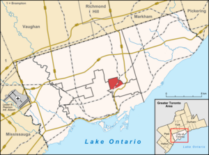
Metropolitan Toronto
Dissolved region in Ontario, Canada
Distance: Approx. 889 meters
Latitude and longitude: 43.7072,-79.3805
The Municipality of Metropolitan Toronto was an upper-tier level of municipal government in Ontario, Canada, from 1953 to 1998. It was made up of the old city of Toronto and numerous townships, towns and villages that surrounded Toronto, which were starting to urbanize rapidly after World War II. It was commonly referred to as "Metro Toronto" or "Metro". Passage of the 1997 City of Toronto Act caused the 1998 amalgamation of Metropolitan Toronto and its constituents into the current City of Toronto.

Leaside
Neighbourhood in Toronto, Ontario, Canada
Distance: Approx. 310 meters
Latitude and longitude: 43.708,-79.368
Leaside (/'liːˌsaɪd/) is a neighbourhood in Toronto, Ontario, Canada. It is located northeast of Downtown Toronto, in the vicinity of Eglinton Avenue East and Bayview Avenue. It is one of the most expensive and exclusive neighbourhoods in the city.

Leaside Aerodrome
Airport in Leaside, Ontario
Distance: Approx. 1173 meters
Latitude and longitude: 43.71277778,-79.35916667
Leaside Aerodrome was an airport in the Town of Leaside, Ontario (now a neighbourhood of Toronto). It opened in 1917 as a Royal Flying Corps airfield during the First World War.
Leaside High School
High school in Toronto, Ontario, Canada
Distance: Approx. 691 meters
Latitude and longitude: 43.7112,-79.3731
Leaside High School is a school of between 900 and 1000 pupils in central-east Toronto, Ontario, Canada, at the corner of Eglinton and Bayview Avenues. The school was established in 1945 by the Leaside Board of Education and is located in the Leaside neighbourhood. Feeder schools for Leaside High School include Bessborough Public School, Bennington Heights Public School, Northlea Public School, and Rolph Road Public School.
Leaside Curling Club
Distance: Approx. 806 meters
Latitude and longitude: 43.70161,-79.36125
Leaside Curling Club is a curling club located in the Leaside neighbourhood of Toronto, Ontario, Canada. The organization was founded in 1963 in response to community requests for a neighbourhood curling club. The City of Toronto built the club's facility in the Leaside Memorial Community Gardens recreational complex, which has eight sheets of curling ice, a lounge, pro shop, bar, and change rooms.

Crothers Woods
Park in Toronto, Ontario, Canada
Distance: Approx. 1239 meters
Latitude and longitude: 43.69777778,-79.35861111
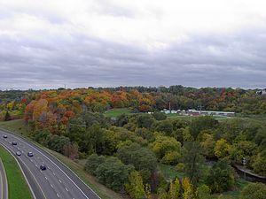
Crothers Woods is an area of the Don River valley in Toronto, Ontario, Canada. It is 52 hectares (128 acres) in size and consists of woodland, meadows, wetlands, and an assortment of past and present municipal uses. The wooded area has been designated as an Environmentally Significant Area (ESA) by the Toronto and Region Conservation Authority.

Toronto Prep School
Private school in Toronto, Ontario, Canada
Distance: Approx. 1449 meters
Latitude and longitude: 43.70063,-79.3864
Toronto Prep School (TPS) is a private school in Toronto, Ontario that was founded in 2009. Toronto Prep School is a Grade 7 through 12, coeducational, private, day school situated on an urban campus in the heart of Toronto near Mount Pleasant Road and Davisville Ave. The school is accredited by the Ontario Ministry of Education.
Sunnybrook School (Toronto)
School in Toronto, Ontario, Canada
Distance: Approx. 1271 meters
Latitude and longitude: 43.69889,-79.38257
Sunnybrook School (SBS) is a coeducational, private elementary school offering Junior Kindergarten to Grade 6, with one class per grade. Founded in 1952 as one of Toronto's first Preschools, Sunnybrook is located on a residential street in North Toronto, specifically in the Mount Pleasant West area of Davisville Village west of Bayview Avenue. Sunnybrook School has been family-run for over 60 years.

Leaside station
Future underground LRT station in Toronto, Canada
Distance: Approx. 854 meters
Latitude and longitude: 43.71111111,-79.37694444
Leaside is an underground light rail transit (LRT) station under construction on Line 5 Eglinton, a new line that is part of the Toronto subway system. It is located in the Leaside neighbourhood at the intersection of Bayview Avenue and Eglinton Avenue. It is scheduled to open in 2024.

Laird station
Future underground LRT station in Toronto, Canada
Distance: Approx. 950 meters
Latitude and longitude: 43.71333333,-79.365
Laird is an underground light rail transit (LRT) station under construction on Line 5 Eglinton, a new line that is part of the Toronto subway system. It is located in the Leaside neighbourhood in East York at the intersection of Laird Drive and Eglinton Avenue. It is scheduled to open in 2024.

Research Enterprises Limited
Distance: Approx. 1445 meters
Latitude and longitude: 43.712821,-79.354868
Research Enterprises Limited (REL for short) was a short-lived Toronto-based Crown Corporation that built electronics and optical instruments during World War II. They existed only six years from late 1940 until 1946, and were active only from late 1941, but during that period they became Leaside's largest employer, producing C$220 million worth of radar systems and optical instruments ($3,677 million in 2025). After the war, the government rapidly closed the various wartime companies it had started. After REL was closed, their factories formed the basis of a Corning Glass plant, Philips Electronics, and a variety of other firms.

Leaside station (Canadian Pacific Railway)
Railway station in Toronto, Ontario, Canada
Distance: Approx. 1100 meters
Latitude and longitude: 43.70444444,-79.35611111
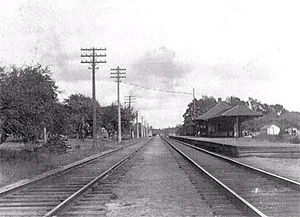
Leaside station is a former railway station in Toronto that served Leaside and Thorncliffe Park. The Canadian Pacific Railway built the station in 1894 to serve the new community of Leaside, on a railway line leased from the Ontario and Quebec Railway. That wooden frame structure burned down in the 1940s and was replaced by a more contemporary building in 1946.
Weather in this IP's area
clear sky
-14 Celsius
-21 Celsius
-15 Celsius
-13 Celsius
1031 hPa
67 %
1031 hPa
1014 hPa
10000 meters
12.07 m/s
14.31 m/s
250 degree
