Country:
 Canada
Region:
City:
Latitude and Longitude:
Time Zone:
Postal Code:
IP information under different IP Channel
ip-api
Country
Region
City
ASN
Time Zone
ISP
Blacklist
Proxy
Latitude
Longitude
Postal
Route
IPinfo
Country
Region
City
ASN
Time Zone
ISP
Blacklist
Proxy
Latitude
Longitude
Postal
Route
MaxMind
Country
Region
City
ASN
Time Zone
ISP
Blacklist
Proxy
Latitude
Longitude
Postal
Route
Luminati
Country
CAASN
Time Zone
America/Toronto
ISP
BPC-76-AS
Latitude
Longitude
Postal
db-ip
Country
Region
City
ASN
Time Zone
ISP
Blacklist
Proxy
Latitude
Longitude
Postal
Route
ipdata
Country
Region
City
ASN
Time Zone
ISP
Blacklist
Proxy
Latitude
Longitude
Postal
Route
Popular places and events near this IP address

Sarnia
City in Ontario, Canada
Distance: Approx. 1991 meters
Latitude and longitude: 42.98138889,-82.31777778
Sarnia is a city in Lambton County, Ontario, Canada. It had a 2021 population of 72,047, and is the largest city on Lake Huron. Sarnia is located on the eastern bank of the junction between the Upper and Lower Great Lakes, where Lake Huron flows into the St.
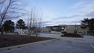
Lambton College
College in Sarnia, Ontario, Canada
Distance: Approx. 744 meters
Latitude and longitude: 42.980525,-82.34858611
Lambton College is a public college located in Sarnia, Ontario, Canada. Founded in 1966, the college offers programs across various fields, including business, health sciences, and engineering technology.

Progressive Auto Sales Arena
Distance: Approx. 462 meters
Latitude and longitude: 42.97694444,-82.34694444
The Progressive Auto Sales Arena is a 5,500-capacity (4,118-seated) multi-purpose arena in Sarnia, Ontario, Canada. It is located on the campus of Lambton College and opened in September 1998. The Progressive Auto Sales Arena is currently home to the Sarnia Sting OHL ice hockey team.

Sarnia Chris Hadfield Airport
Airport in Ontario, Canada
Distance: Approx. 3662 meters
Latitude and longitude: 42.99972222,-82.30944444
Sarnia Chris Hadfield Airport (IATA: YZR, ICAO: CYZR) is located 4 nautical miles (7.4 km; 4.6 mi) east northeast of Sarnia, Ontario, Canada. Opened in 1958 for scheduled flights, the airport was renamed in honour of Canadian Space Agency astronaut and Sarnia native Chris Hadfield in 1997. The airport is classified as an airport of entry by Nav Canada and is staffed by the Canada Border Services Agency (CBSA).
École secondaire Franco-Jeunesse
High school in Sarnia, Ontario, Canada
Distance: Approx. 3564 meters
Latitude and longitude: 42.9971,-82.3748
École secondaire Franco-Jeunesse is a French high school in Sarnia, Ontario, Canada and is administered by the Conseil scolaire Viamonde. Franco-Jeunesse opened up a new school as of September 2012. The school was previously conjoined with NCIVS, but now neighbours SFX and the French community centre.

Lambton Mall
Shopping mall
Distance: Approx. 1133 meters
Latitude and longitude: 42.982,-82.353
Lambton Mall is a shopping mall located in Sarnia, Ontario, Canada, owned by Chicago real estate company Cushman and Wakefield. It opened in 1971 and, through several expansions, has grown to encompass over 580,000 square feet of retail space.
Great Lakes Secondary School
School in Sarnia, Lambton County, Ontario, Canada
Distance: Approx. 2289 meters
Latitude and longitude: 42.96674,-82.36603
Great Lakes Secondary School (GLSS) is a high school in Sarnia, Ontario. It was previously named St. Clair Secondary School, and it was renamed after being consolidated with Sarnia Collegiate Institute and Technical School.

1953 Sarnia tornado
Storm in Ontario, Canada
Distance: Approx. 4905 meters
Latitude and longitude: 42.96666667,-82.4
On the afternoon of Thursday, May 21, 1953, a violent F4 tornado struck the cities of Port Huron, Michigan, United States and Sarnia, Ontario, Canada. The long-tracked, over mile-wide tornado destroyed large sections of the downtown areas of both cities, as well scores of neighbourhoods in the surrounding areas and then ending just outside Stratford, Ontario,Canada. Seven people were killed, 117 others were injured, and damages were estimated $17.6 million (1953 USD).

Lakeview cemetery, Sarnia
Cemetery in Ontario, Canada
Distance: Approx. 4095 meters
Latitude and longitude: 42.9952,-82.3846
Lakeview Cemetery Company is a cemetery located at Colborne Road and Michigan Avenue in Sarnia, Ontario. Opened in 1879 by the Town of Sarnia to replace smaller and church-based cemeteries, it is most notable for being the burial place of Canadian Prime Minister Alexander Mackenzie.
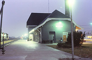
Sarnia station
Railway station in Ontario, Canada
Distance: Approx. 4433 meters
Latitude and longitude: 42.9572,-82.3889
Sarnia station (also Sarnia Tunnel Station) is a Via Rail train station in Sarnia, Ontario, Canada. It is the western terminus for Via Rail trains running from Toronto through southwestern Ontario. The unstaffed station is wheelchair accessible.

Sarnia Photovoltaic Power Plant
Photovoltaic power station in Ontario, Canada
Distance: Approx. 4311 meters
Latitude and longitude: 42.93777778,-82.34166667
Sarnia Photovoltaic Power Plant near Sarnia, Ontario, is Canada's largest photovoltaic plant with an installed capacity of 97 MWP (80 MWAC). In 2009, Ontario introduced a feed-in tariff renewable energy payments program paying up to CDN 44.3 cents per kW·h for large ground arrays such as the Sarnia plant. This makes Ontario's one of the top feed in tariff programs in the world.
Bluewater Health
Hospital in Ontario, Canada
Distance: Approx. 3991 meters
Latitude and longitude: 42.976802,-82.390299
Bluewater Health is a hospital in Sarnia, Ontario. It was opened October 3, 1896 as Sarnia General Hospital and was the community's first public hospital. In 2010, with extensive renovations to the two existing buildings and construction of a third, it was renamed Bluewater Health.
Weather in this IP's area
scattered clouds
16 Celsius
16 Celsius
15 Celsius
17 Celsius
1013 hPa
96 %
1013 hPa
992 hPa
10000 meters
2.67 m/s
3.14 m/s
167 degree
27 %
07:15:00
19:30:19