Country:
 USA
USARegion:
City:
Latitude and Longitude:
Time Zone:
Postal Code:
IP information under different IP Channel
ip-api
Country
Region
City
ASN
Time Zone
ISP
Blacklist
Proxy
Latitude
Longitude
Postal
Route
IPinfo
Country
Region
City
ASN
Time Zone
ISP
Blacklist
Proxy
Latitude
Longitude
Postal
Route
MaxMind
Country
Region
City
ASN
Time Zone
ISP
Blacklist
Proxy
Latitude
Longitude
Postal
Route
Luminati
Country
USRegion
mn
City
minneapolis
ASN
Time Zone
America/Chicago
ISP
USINTERNET
Latitude
Longitude
Postal
db-ip
Country
Region
City
ASN
Time Zone
ISP
Blacklist
Proxy
Latitude
Longitude
Postal
Route
ipdata
Country
Region
City
ASN
Time Zone
ISP
Blacklist
Proxy
Latitude
Longitude
Postal
Route
Popular places and events near this IP address
Metropolitan Airports Commission
Distance: Approx. 1605 meters
Latitude and longitude: 44.893,-93.2331
The Minneapolis-Saint Paul Metropolitan Airports Commission (MAC) is a state-level airport authority that operates the Minneapolis–Saint Paul International Airport and six reliever airports in the Twin Cities region, which primarily provide service to private individuals and businesses, but also have regional transportation service.

Lake Nokomis
Lake in the state of Minnesota, United States
Distance: Approx. 362 meters
Latitude and longitude: 44.90944444,-93.24222222
Lake Nokomis is one of several lakes in Minneapolis, Minnesota, and part of the city's Chain of Lakes. The lake was previously named Lake Amelia in honor of Captain George Gooding's daughter, Amelia, in 1819. Its current name was adopted in 1910 to honor Nokomis, grandmother of Hiawatha.

Lake Hiawatha
Distance: Approx. 1641 meters
Latitude and longitude: 44.92083333,-93.23638889
Lake Hiawatha is located just north of Lake Nokomis in Minneapolis, Minnesota. It was purchased by the Minneapolis Park and Recreation Board in 1922 for $550,000. At that time the lake was a marsh known as Rice Lake, but over four years, the park system transformed the wetland into a lake surrounded by a park.
Hale, Minneapolis
Neighborhood of Nokomis, Minneapolis
Distance: Approx. 1236 meters
Latitude and longitude: 44.9094,-93.2557
Hale is a neighborhood (within the larger Nokomis community) near the southern edge of Minneapolis. It lies south of Minnehaha Creek, north of 55th Street, east of Chicago Avenue, and west of Cedar Avenue. It is a part of Ward 11, currently represented by city council member Emily Koski.
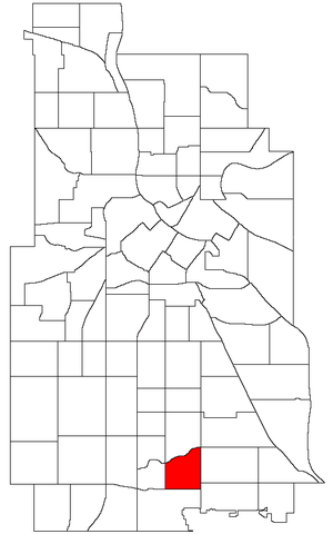
Nokomis, Minneapolis
Community of Minneapolis
Distance: Approx. 590 meters
Latitude and longitude: 44.9072,-93.248
Nokomis is a defined community in Minneapolis, Minnesota. It takes its name from Lake Nokomis. It comprises eleven smaller neighborhoods.

Nokomis Library
Public library in Minneapolis, Minnesota, USA
Distance: Approx. 1443 meters
Latitude and longitude: 44.910525,-93.22324722
Nokomis Library, formerly Nokomis Community Library, is a branch library serving the Nokomis East area of Minneapolis, Minnesota. One of 41 libraries in the Hennepin County Library system, Nokomis was designed by Buetow and Associates, Inc and opened in 1968 as a replacement for the nearby Longfellow Community Library. After being deemed crowded and outdated in 1999, the library underwent a renovation beginning in 2009 that saw it gain a number of environmentally friendly features and an expansion of 4,300 square feet (399 m2).

Northrop, Minneapolis
Neighborhood in Hennepin, Minnesota, United States
Distance: Approx. 1868 meters
Latitude and longitude: 44.91972222,-93.255
Northrop is a neighborhood located in the Nokomis community in Minneapolis, Minnesota, United States. The neighborhood is bordered by 42nd Street to the north, Cedar Avenue to the east, Minnehaha Parkway to the south, and Chicago Avenue to the west. Most of Northrop is in Ward 11, currently represented by city council member and Emily Koski.

Keewaydin, Minneapolis
Neighborhood of Nokomis, Minneapolis
Distance: Approx. 554 meters
Latitude and longitude: 44.9099,-93.2356
Keewaydin ( kee-WAY-din) is a neighborhood in the Nokomis community in Minneapolis, Minnesota. Its boundaries are Minnehaha Parkway to the north, 34th Avenue to the east, 54th Street to the south, and Cedar Avenue to the west. The neighborhood contains the majority of Lake Nokomis.

Wenonah, Minneapolis
Neighborhood of Nokomis, Minneapolis
Distance: Approx. 1234 meters
Latitude and longitude: 44.8959,-93.2356
Wenonah is a neighborhood on the southeast side of Minneapolis, Minnesota. Its boundaries are 54th Street to the north, 34th Avenue to the east, the Minneapolis-Saint Paul International Airport to the south, and Cedar Avenue to the west. The neighborhood contains a portion of Lake Nokomis.

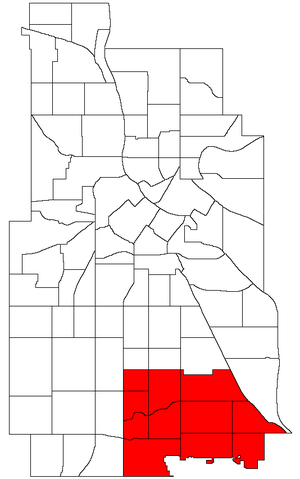
Nokomis East
Group of neighborhoods in Minneapolis, Minnesota, United States
Distance: Approx. 1411 meters
Latitude and longitude: 44.90527778,-93.22277778
Nokomis East is a group of neighborhoods in the southeastern corner of Minneapolis, Minnesota, United States. It consists of four neighborhoods: Keewaydin, Minnehaha, Morris Park and Wenonah. Nokomis East contains two schools, the Nokomis Community Library, and a post office.

Nokomis Knoll Residential Historic District
Historic district in Minnesota, United States
Distance: Approx. 790 meters
Latitude and longitude: 44.90722222,-93.25055556
Nokomis Knoll Residential Historic District is a neighborhood of houses near Lake Nokomis in Minneapolis, Minnesota, United States. The district was listed on the National Register of Historic Places in 1999 and features a number of homes built in popular revival architecture styles of the 1920s, 1930s, and early 1940s. The styles include French and Italian Renaissance, Tudor Revival, Spanish Colonial Revival, and Colonial Revival.
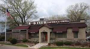
5-8 Club
Restaurant in Minneapolis, Minnesota
Distance: Approx. 1125 meters
Latitude and longitude: 44.8977096,-93.2478934
The 5-8 Club Tavern & Grill is a restaurant in Minneapolis, Minnesota. Founded in 1928 as a speakeasy, the eatery is one of two Minneapolis establishments that claim to have invented the Juicy Lucy cheeseburger in the 1950s, the other being Matt's Bar. The 5-8 Club also serves its Saucy Sally burger and other dishes including fried cheese curds and onion straws.
Weather in this IP's area
clear sky
13 Celsius
13 Celsius
11 Celsius
14 Celsius
1019 hPa
79 %
1019 hPa
990 hPa
10000 meters
3.6 m/s
240 degree
06:44:08
19:37:08