Country:
Region:
City:
Latitude and Longitude:
Time Zone:
Postal Code:
IP information under different IP Channel
ip-api
Country
Region
City
ASN
Time Zone
ISP
Blacklist
Proxy
Latitude
Longitude
Postal
Route
Luminati
Country
Region
tx
City
hurst
ASN
Time Zone
America/Chicago
ISP
FORTINET
Latitude
Longitude
Postal
IPinfo
Country
Region
City
ASN
Time Zone
ISP
Blacklist
Proxy
Latitude
Longitude
Postal
Route
db-ip
Country
Region
City
ASN
Time Zone
ISP
Blacklist
Proxy
Latitude
Longitude
Postal
Route
ipdata
Country
Region
City
ASN
Time Zone
ISP
Blacklist
Proxy
Latitude
Longitude
Postal
Route
Popular places and events near this IP address

Hurst, Texas
City in Texas, United States
Distance: Approx. 3874 meters
Latitude and longitude: 32.85555556,-97.18027778
Hurst is a city in the U.S. state of Texas located in the densely populated portion of northeastern Tarrant County and is part of the Dallas–Fort Worth metropolitan area. It is considered a Dallas and Fort Worth suburb and is part of the Mid-Cities region. It is 13 miles from the Dallas/Fort Worth International Airport.

Bell station (TRE)
Commuter rail station in Fort Worth, Texas
Distance: Approx. 2702 meters
Latitude and longitude: 32.8046,-97.1551
Bell station (formerly Hurst/Bell station) is a Trinity Railway Express commuter rail station in Fort Worth, Texas. The station is located near Fort Worth's border with Hurst, 1⁄4 mile (0.40 km) south of Hurst Boulevard (SH 10). The station serves the headquarters and main plant of aerospace manufacturer Bell Textron.
Tyndale Theological Seminary
Distance: Approx. 774 meters
Latitude and longitude: 32.823414,-97.184216
Tyndale Theological Seminary is an American private Christian seminary with its campus in Hurst, Texas. It has chosen not to seek state accreditation for religious reasons.
L. D. Bell High School
Co-educational, public, secondary school in Hurst, Tarrant County, Texas, United States
Distance: Approx. 2768 meters
Latitude and longitude: 32.842911,-97.162727
Lawrence Dale Bell High School (generally known as L.D. Bell High School and also known as Hurst Bell) is an American high school located in the cities of Hurst and Bedford, Texas and part of the Hurst-Euless-Bedford Independent School District. The school is named for Lawrence Dale Bell, the founder of nearby Bell Helicopter Textron, and was recognized as a National Blue Ribbon School for 1994–96. L. D. Bell's marching band won the Bands of America Grand National Championship in 2007.

North East Mall
Shopping mall in Texas
Distance: Approx. 2397 meters
Latitude and longitude: 32.83,-97.19972222
North East Mall (previously as Northeast Mall) is an American super-regional shopping mall located in Hurst, Texas, United States, a suburb in the Dallas/Fort Worth metroplex. It is located below highways SH 121, SH 183, and is east of Interstate Highway 820 S. It features two units, the main mall and the outside being the Shops at North East Mall both encompassing a total of 2,134,000 square feet (198,000 m2) and featuring 135 stores. The mall features Macy's, Dillard's, Dick's Sporting Goods, and Penney's.

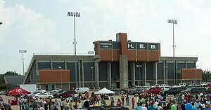
Pennington Field
Distance: Approx. 3979 meters
Latitude and longitude: 32.832755,-97.136374
Pennington Field is a multi-purpose stadium located in Bedford, Texas. The 12,500-capacity facility is primarily used for local high school football and soccer teams of Trinity High School and L.D. Bell High School. It is owned and operated by the Hurst-Euless-Bedford Independent School District.
Artisan Center Theater
Distance: Approx. 1271 meters
Latitude and longitude: 32.8236,-97.1633
Artisan Center Theater is a community theater based in the Dallas/Fort Worth area. The theater operates a 195-seat, theater in the round that features musicals. Additionally, it has a second stage of 150-seats where performances of comedies, light dramas, musical reviews and children performing for children in the Artisan Children's Theater used to be performed.
St. Vincent's Cathedral School
School in Texas, United States of America
Distance: Approx. 3493 meters
Latitude and longitude: 32.83127,-97.141262
St. Vincent's School was a private Anglican school in Bedford, Texas, United States. It was a school of St.
NRH2O
Water park in North Richland Hills, Texas
Distance: Approx. 3677 meters
Latitude and longitude: 32.850577,-97.193749
NRH2O Family Water Park, stylized as NRH2O, is a water park located in North Richland Hills, Texas, owned by the City of North Richland Hills. The park opened in 1995 and contains water slides, a swimming pool, a wave pool, and a lazy river.
KEYS High School
Co-educational, public, secondary school in Euless, Tarrant County, Texas, United States
Distance: Approx. 3830 meters
Latitude and longitude: 32.82111111,-97.13555556
KEYS High School, formerly known as KEYS Learning Center, is a public alternative high school in Euless, Texas, United States. It is part of the Hurst-Euless-Bedford Independent School District. KEYS primarily serves students ages 16 through 21 who are unable to remain at either L.D. Bell or Trinity high schools due to academic, economic, or personal needs.

St. Vincent's Cathedral
Anglican cathedral of the Episcopal Diocese of Fort Worth
Distance: Approx. 3464 meters
Latitude and longitude: 32.8313,-97.1416
St. Vincent's Cathedral is an Anglican church in Bedford, Texas. It is the cathedral of the Episcopal Diocese of Fort Worth.
Trinity Lakes station
Commuter rail station in Fort Worth, Texas
Distance: Approx. 3531 meters
Latitude and longitude: 32.8055,-97.2095
Trinity Lakes station is a Trinity Railway Express commuter rail station. The station is located in eastern Fort Worth, Texas, on the border with Hurst, Texas, just to the east of Interstate 820 and north of Trinity Boulevard. The station is a part of Trinity Lakes, a 1,600-acre master planned mixed-use transit-oriented development.
Weather in this IP's area
mist
21 Celsius
21 Celsius
20 Celsius
22 Celsius
1014 hPa
81 %
1014 hPa
995 hPa
10000 meters
6.17 m/s
90 degree
100 %
06:53:10
17:31:54