Country:
 USA
USARegion:
City:
Latitude and Longitude:
Time Zone:
Postal Code:
IP information under different IP Channel
ip-api
Country
Region
City
ASN
Time Zone
ISP
Blacklist
Proxy
Latitude
Longitude
Postal
Route
IPinfo
Country
Region
City
ASN
Time Zone
ISP
Blacklist
Proxy
Latitude
Longitude
Postal
Route
MaxMind
Country
Region
City
ASN
Time Zone
ISP
Blacklist
Proxy
Latitude
Longitude
Postal
Route
Luminati
Country
USRegion
or
City
newport
ASN
Time Zone
America/Los_Angeles
ISP
AS-WAVE-1
Latitude
Longitude
Postal
db-ip
Country
Region
City
ASN
Time Zone
ISP
Blacklist
Proxy
Latitude
Longitude
Postal
Route
ipdata
Country
Region
City
ASN
Time Zone
ISP
Blacklist
Proxy
Latitude
Longitude
Postal
Route
Popular places and events near this IP address

Yaquina Bay Light
Lighthouse
Distance: Approx. 2815 meters
Latitude and longitude: 44.62415,-124.0629
The Yaquina Bay Light is a lighthouse that was built in 1871, soon after the founding of the city of Newport, Oregon, in the United States. It is located on the north side of Yaquina Bay. In 1871–1874, it was the busiest and most populated of the many coastal ports between Washington and California.
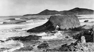
Jump-off Joe
Former rock pillar on Oregon's coast
Distance: Approx. 984 meters
Latitude and longitude: 44.645395,-124.062617
Jump-off Joe was a 100-foot-tall sea stack geological formation composed of middle Miocene concretionary sandstone at Nye Beach in Newport, Oregon, United States. It was a well-known tourist attraction before World War I. It formed sometime before the 1880s when it was connected to the mainland, and was a major impediment walking the beach. Early travelers would have to jump off the side to get over it, hence the name.

Newport High School (Oregon)
Public school in Newport, Oregon, United States
Distance: Approx. 1089 meters
Latitude and longitude: 44.638708,-124.045992
Newport High School is a public high school located in Newport, Oregon, United States. It is one of five high schools in the Lincoln County School District.

Agate Beach State Recreation Site
State Recreation Site in Oregon, United States
Distance: Approx. 1343 meters
Latitude and longitude: 44.6587278,-124.0581726
Agate Beach State Recreation Site is a state park between Newport and Agate Beach in Lincoln County in the U.S. state of Oregon. It is administered by the Oregon Parks and Recreation Department. Lying between new and old U.S. Highway 101, the 18.48-acre (7.48 ha) park offers beach access via a path from the parking lot through a tunnel under the old highway.
RV Wecoma
Distance: Approx. 2517 meters
Latitude and longitude: 44.625679,-124.044826
RV Wecoma is a research vessel owned by the National Science Foundation and operated by the College of Oceanic & Atmospheric Sciences at Oregon State University (OSU) as a member of the University-National Oceanographic Laboratory System (UNOLS) fleet. It is based in Newport in the U.S. state of Oregon near OSU's Hatfield Marine Science Center. Launched in 1975, it has a maximum displacement of 1,150 long tons (1,168 t).
Lincoln County School District (Oregon)
Public school district in Oregon, United States
Distance: Approx. 1797 meters
Latitude and longitude: 44.6325,-124.05749
The Lincoln County School District is a public school district in the U.S. state of Oregon. The district serves the communities of Yachats, Waldport, Eddyville, Newport, Siletz, Lincoln City and Toledo. The district spans roughly 55 miles of the central Oregon Coast from Cascade Head south to Cape Perpetua, and encompasses about 1,000 square miles.
KWPB-LP
Radio station in Newport, Oregon
Distance: Approx. 186 meters
Latitude and longitude: 44.64916667,-124.05222222
KWPB-LP (98.7 FM, "Winds of Praise") is a low-power radio station broadcasting a contemporary Christian music format. Licensed to Newport, Oregon, United States, the station is currently owned by Winds of Praise Broadcasting.
Newport Heights, Oregon
Unincorporated community in the state of Oregon, United States
Distance: Approx. 2081 meters
Latitude and longitude: 44.644,-124.025
Newport Heights is an unincorporated community in Lincoln County, Oregon, United States.

New Cliff House
United States historic place
Distance: Approx. 1406 meters
Latitude and longitude: 44.638238,-124.06213
New Cliff House, also formerly known as the Hotel Gilmore and now known as the Sylvia Beach Hotel, is a historic hotel building in Newport, Oregon.

Nye Beach
Central district in Newport, Oregon, U.S.
Distance: Approx. 1071 meters
Latitude and longitude: 44.64111111,-124.06027778
Nye Beach is a central district in Newport in the U.S. state of Oregon. The Nye Beach historic overlay district is bounded on the north and south sides by Northwest Twelfth Street and Southwest Second Street respectively; on the east side by Hurbert Street and on the west side by the Pacific Ocean. Situated on a sea cliff, the district has been a popular vacation spot since the late 19th century.

Charles and Theresa Roper House
Historic house in Oregon, United States
Distance: Approx. 1749 meters
Latitude and longitude: 44.633346,-124.059009
The Charles and Theresa Roper House, also known as Hilan Castle, is a historic residence located in Newport, Oregon, United States. Built in 1912–1913 to evoke a castle in the Scottish Highlands, it features such Medieval-inspired elements as a crenellated parapet, mullioned windows, a rounded corner tower, and a cantilevered turret. It is one of very few examples of the Castellated Gothic Revival style in Oregon, other than local armories.
Oregon Undersea Gardens
Former aquarium in Newport, Oregon, U.S.
Distance: Approx. 1961 meters
Latitude and longitude: 44.63030556,-124.05191667
Oregon Undersea Gardens was an underwater aquarium in Newport, Oregon, United States. The tourist attraction opened in 1966, and plans to close were announced in 2019.
Weather in this IP's area
mist
15 Celsius
15 Celsius
14 Celsius
15 Celsius
1013 hPa
96 %
1013 hPa
1007 hPa
6437 meters
100 %
06:47:42
19:39:59