Country:
Region:
City:
Latitude and Longitude:
Time Zone:
Postal Code:
IP information under different IP Channel
ip-api
Country
Region
City
ASN
Time Zone
ISP
Blacklist
Proxy
Latitude
Longitude
Postal
Route
IPinfo
Country
Region
City
ASN
Time Zone
ISP
Blacklist
Proxy
Latitude
Longitude
Postal
Route
MaxMind
Country
Region
City
ASN
Time Zone
ISP
Blacklist
Proxy
Latitude
Longitude
Postal
Route
Luminati
Country
Region
or
City
woodburn
ASN
Time Zone
America/Los_Angeles
ISP
AS-WAVE-1
Latitude
Longitude
Postal
db-ip
Country
Region
City
ASN
Time Zone
ISP
Blacklist
Proxy
Latitude
Longitude
Postal
Route
ipdata
Country
Region
City
ASN
Time Zone
ISP
Blacklist
Proxy
Latitude
Longitude
Postal
Route
Popular places and events near this IP address

Woodburn, Oregon
City in Oregon, United States
Distance: Approx. 954 meters
Latitude and longitude: 45.14777778,-122.86666667
Woodburn is a city in Marion County, Oregon, United States. Incorporated in 1889, the community had been platted in 1871 after the arrival of the railroad. The city is located in the northern end of the Willamette Valley between Portland and Salem.

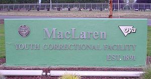
MacLaren Youth Correctional Facility
Juvenile correctional facility in Oregon, U.S.
Distance: Approx. 3005 meters
Latitude and longitude: 45.154564,-122.828597
MacLaren Youth Correctional Facility is a juvenile correctional facility in unincorporated Marion County, Oregon, United States, near Woodburn.
Woodburn Premium Outlets
Shopping mall in United States, /
Distance: Approx. 2247 meters
Latitude and longitude: 45.156138,-122.878561
Woodburn Premium Outlets is an outlet mall in Woodburn, Oregon, United States. The complex, located between the cities of Portland and Salem on Interstate 5, opened in 1999 as the Woodburn Company Stores. Owned and operated by Simon Property Group, the center has over 350,000 square feet (33,000 m2) of retail space.

Jesse H. Settlemier House
Historic house in Oregon, United States
Distance: Approx. 819 meters
Latitude and longitude: 45.1475,-122.85972222
Jesse H. Settlemier House is a historic house in Woodburn, Oregon, United States. It was built by Jesse H. Settlemier, founder of Woodburn, in 1892. The house is no longer inhabited but is open to the public as a museum and as a location for special events such as weddings.

Woodburn High School
Public school in Woodburn, , Oregon, United States
Distance: Approx. 1693 meters
Latitude and longitude: 45.1534422,-122.8503993
Woodburn High School (WHS) is a four-year public high school located in Woodburn, Oregon, United States.

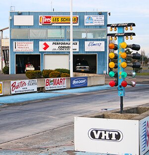
Woodburn Dragstrip
Dragstrip in Woodburn, Oregon, U.S.
Distance: Approx. 4000 meters
Latitude and longitude: 45.156077,-122.906699
The Woodburn Dragstrip is a quarter-mile NHRA dragstrip located in Woodburn, Oregon. Woodburn Dragstrip opened in June 1961 as an ⅛-mile dragstrip operated by the Multnomah Hot Rod Council and the Northwest Timing Association. In 1963, the track was lengthened to provide for 1/4-mile drag racing.

OGA Golf Course
Distance: Approx. 2501 meters
Latitude and longitude: 45.1606164,-122.8477049
The Oregon Golf Association (OGA) Golf Course is a public golf course located in Woodburn, Oregon. The course was rated by Golf Digest in 1996 as "One of the Top Ten Affordable Courses in the US." It is located at 45.1606164°N 122.8477049°W / 45.1606164; -122.8477049.
William P. Lord High School
Public school in Woodburn, Marion County, Oregon, United States
Distance: Approx. 2988 meters
Latitude and longitude: 45.154458,-122.828758
William P. Lord High School is a public high school in Woodburn, Oregon, United States. It is named after William Paine Lord, the Governor of Oregon from 1895 to 1899. It is located at the MacLaren Youth Correctional Facility, and operates a vocational tech program.

Woodburn Success Alternative High School
Public school in Woodburn, Marion County, Oregon, United States
Distance: Approx. 715 meters
Latitude and longitude: 45.139405,-122.851959
Woodburn Success Alternative High School, also known as Woodburn Success School, is a public alternative high school in Woodburn, Oregon, United States.
KPVN-LP
Radio station in Woodburn, Oregon
Distance: Approx. 427 meters
Latitude and longitude: 45.14138889,-122.85583333
KPVN-LP (95.9 FM) was a low-power radio station licensed to Woodburn, Oregon, United States. The station was owned by Centro De Servicios Para Campesinos Inc. The station shared its program hours with KPCN-LP, a similar station owned by the Pineros y Campesinos Unidos del Noroeste; that station left the air on November 20, 2019, and was effectively replaced by KTUP (98.3 FM).
Woodburn bank bombing
2008 explosion in Oregon, US
Distance: Approx. 1567 meters
Latitude and longitude: 45.15074,-122.87423
The Woodburn bank bombing was a bomb explosion that occurred on December 12, 2008, when a bomb that had been moved by a bomb squad technician into the West Coast Bank in Woodburn, Oregon exploded, killing two officers and seriously injuring a third.
Woodburn station
Distance: Approx. 539 meters
Latitude and longitude: 45.1431,-122.8555
Woodburn station was a train station in Woodburn, Oregon.
Weather in this IP's area
clear sky
16 Celsius
16 Celsius
15 Celsius
18 Celsius
1012 hPa
77 %
1012 hPa
1005 hPa
10000 meters
1.54 m/s
180 degree
06:42:31
19:35:39
