Country:
Region:
City:
Latitude and Longitude:
Time Zone:
Postal Code:
IP information under different IP Channel
ip-api
Country
Region
City
ASN
Time Zone
ISP
Blacklist
Proxy
Latitude
Longitude
Postal
Route
Luminati
Country
Region
md
City
hanover
ASN
Time Zone
America/New_York
ISP
AS10298
Latitude
Longitude
Postal
IPinfo
Country
Region
City
ASN
Time Zone
ISP
Blacklist
Proxy
Latitude
Longitude
Postal
Route
db-ip
Country
Region
City
ASN
Time Zone
ISP
Blacklist
Proxy
Latitude
Longitude
Postal
Route
ipdata
Country
Region
City
ASN
Time Zone
ISP
Blacklist
Proxy
Latitude
Longitude
Postal
Route
Popular places and events near this IP address

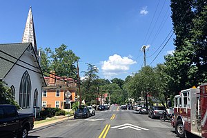
Clifton, Virginia
Town in Virginia, United States
Distance: Approx. 780 meters
Latitude and longitude: 38.78,-77.38638889
Clifton is an incorporated town located in southwestern Fairfax County, Virginia, United States, with a population of 243 at the time of the 2020 census. Incorporated by the General Assembly on March 9, 1902, Clifton is one of only three towns in the county, the other two being the much more populous Vienna and Herndon. Clifton's history begins pre-colonially, when the area was used as hunting grounds by the local Dogue Native American tribe.
Bunny Man
Urban legend
Distance: Approx. 1600 meters
Latitude and longitude: 38.78985,-77.36225
The Bunny Man is an urban legend that originated from two incidents in Fairfax County, Virginia, in 1970, but has been spread throughout the Washington, D.C., and Maryland areas. The legend has many variations; most involve a man wearing a rabbit costume who attacks people with an axe or hatchet. Most of the stories occur around Colchester Overpass, a Southern Railway overpass spanning Colchester Road near Clifton, Virginia, sometimes referred to as "Bunny Man Bridge".
Colchester Hunt, Virginia
Unincorporated community in Virginia, United States
Distance: Approx. 2797 meters
Latitude and longitude: 38.80555556,-77.36222222
Colchester Hunt is an unincorporated community in Fairfax County, Virginia, United States. Colchester Hunt is located close to the town of Clifton and the independent city of Fairfax.

Hemlock Overlook Regional Park
Park in Virginia, United States
Distance: Approx. 3067 meters
Latitude and longitude: 38.770187,-77.409623
Hemlock Overlook Regional Park is a multi-use park near Clifton, Virginia, one of several parks lining the Bull Run. The 400-acre park offers dense forests, hilly woodlands, and floodplain scenery. Hemlock Overlook is named after the grove of hemlock trees above the banks in the northern section of the park.
Lewis Park, Virginia
Unincorporated community in Virginia, United States
Distance: Approx. 4085 meters
Latitude and longitude: 38.82083333,-77.37638889
Lewis Park is an unincorporated community in Fairfax County, in the U.S. state of Virginia.
Hope Park
Historic house in Virginia, United States
Distance: Approx. 3509 meters
Latitude and longitude: 38.81416667,-77.36666667
Hope Park was an 18th and 19th-century plantation in Fairfax County, Virginia, where Dr. David Stuart (1753–1814), an old friend of and correspondent with George Washington lived with his wife, (Washington's former stepdaughter-in-law) Eleanor Calvert Custis (1758–1811), and family. It was approximately 5 miles (8.0 km) southwest of Fairfax Court House (now known as the independent city of Fairfax).
Clifton Historic District (Clifton, Virginia)
Historic district in Virginia, United States
Distance: Approx. 818 meters
Latitude and longitude: 38.77944444,-77.38638889
Clifton Historic District is a national historic district located at Clifton, Fairfax County, Virginia. It encompasses 62 contributing buildings, 1 contributing site, and 1 contributing object in the town of Clifton. They include 53 residences, 3 churches, 4 commercial buildings, and 2 local government buildings mostly built between 1880 and 1910.

"A" Fort and Battery Hill Redoubt-Camp Early
United States historic place
Distance: Approx. 4255 meters
Latitude and longitude: 38.78944444,-77.42777778
"A" Fort and Battery Hill Redoubt-Camp Early, also known as Measles Fort, is a historic American Civil War military facility and redoubt located in Fairfax County, Virginia south of Centreville and along Bull Run. It was listed on the National Register of Historic Places in 1998.

Orange and Alexandria Railroad Bridge Piers
United States historic place
Distance: Approx. 3780 meters
Latitude and longitude: 38.776436,-77.421606
The Orange and Alexandria Railroad Bridge Piers are the historical remains of a bridge that carried the Orange and Alexandria Railroad across Bull Run between Fairfax and Prince William Counties, Virginia. The railroad, and this bridge location in particular, were of strategic interest to both Union and Confederate forces during the American Civil War. The bridge was rebuilt at least seven times during the war years.

Clifton station (VRE)
Distance: Approx. 696 meters
Latitude and longitude: 38.781215,-77.386253
Clifton station is a limited-use Virginia Railway Express train station in Clifton, Virginia. The location serves as a station stop during special seasonal events in the town, most notably the town's annual Clifton Day. It is served by special Manassas Line trains running between Manassas station and Rolling Road station.
Union Mill, Virginia
Census-designated place in Virginia
Distance: Approx. 1544 meters
Latitude and longitude: 38.798,-77.381
Union Mill is a census designated place in Fairfax County, Virginia, United States.
Chapel Road Park
Park in Fairfax County, Virginia, US
Distance: Approx. 868 meters
Latitude and longitude: 38.7788845,-77.3718882
Chapel Road Park is a 25 acres (10 ha) park one mile east of Clifton in Fairfax County, Virginia.
Weather in this IP's area
overcast clouds
20 Celsius
20 Celsius
18 Celsius
21 Celsius
1020 hPa
64 %
1020 hPa
1012 hPa
10000 meters
3.6 m/s
330 degree
100 %
06:43:38
17:02:51

