Country:
Region:
City:
Latitude and Longitude:
Time Zone:
Postal Code:
IP information under different IP Channel
ip-api
Country
Region
City
ASN
Time Zone
ISP
Blacklist
Proxy
Latitude
Longitude
Postal
Route
Luminati
Country
ASN
Time Zone
America/Toronto
ISP
RISQ-AS
Latitude
Longitude
Postal
IPinfo
Country
Region
City
ASN
Time Zone
ISP
Blacklist
Proxy
Latitude
Longitude
Postal
Route
db-ip
Country
Region
City
ASN
Time Zone
ISP
Blacklist
Proxy
Latitude
Longitude
Postal
Route
ipdata
Country
Region
City
ASN
Time Zone
ISP
Blacklist
Proxy
Latitude
Longitude
Postal
Route
Popular places and events near this IP address

Jonquière
Borough of Saguenay, Quebec, Canada
Distance: Approx. 1176 meters
Latitude and longitude: 48.41666667,-71.25
Jonquière (; French pronunciation: [ʒɔ̃kjɛʁ]; 2021 population: 60,250) is a borough (arrondissement) of the city of Saguenay in the Saguenay–Lac-Saint-Jean region of Quebec, Canada. It is located on the Saguenay River, near the borough of Chicoutimi.

Arvida, Quebec
Distance: Approx. 5640 meters
Latitude and longitude: 48.43333333,-71.18333333
Arvida ( ar-VY-də) is a settlement of 12,000 people (2010) in Quebec, Canada, that is part of the City of Saguenay. Its name is derived from the name of its founder, Arthur Vining Davis, president of the Alcoa aluminum company. Arvida was founded as an industrial city by Alcoa in 1927, when the first aluminum smelter was constructed.

Jonquière (provincial electoral district)
Provincial electoral district in Quebec, Canada
Distance: Approx. 3404 meters
Latitude and longitude: 48.378,-71.23
Jonquière is a provincial electoral district in the Saguenay–Lac-Saint-Jean region of Quebec, Canada that elects members to the National Assembly of Quebec. It is located within the city of Saguenay and consists of most of the borough of Jonquière. It was created for the 1966 election from parts of Jonquière-Kénogami and Lac-Saint-Jean electoral districts.

Jonquière station
Railway station in Quebec, Canada
Distance: Approx. 818 meters
Latitude and longitude: 48.4121,-71.2544
Jonquière station is a Via Rail station in Saguenay, Quebec, Canada. It is located on rue Saint-Dominique in the former city of Jonquière. It is the final stop of Via Rail's Montreal–Jonquière train.
Maisonneuve (provincial electoral district)
Provincial electoral district in Quebec, Canada
Distance: Approx. 7334 meters
Latitude and longitude: 48.359,-71.317
Maisonneuve was a former provincial electoral district in the Montreal region of Quebec, Canada. It was created for the 1912 election from part of Hochelaga electoral district. Its final election was in 1985.
Jonquière-Kénogami
Provincial electoral district in Quebec, Canada
Distance: Approx. 7334 meters
Latitude and longitude: 48.359,-71.317
Jonquière-Kénogami was a former provincial electoral district in the Saguenay–Lac-Saint-Jean region of Quebec, Canada that elected members to the Legislative Assembly of Quebec. It was created for the 1956 election, from parts of the existing Chicoutimi and Lac-Saint-Jean electoral districts. Its final election was in 1962.
Saint-Jean-Vianney
Village in Québec, Canada
Distance: Approx. 7697 meters
Latitude and longitude: 48.472794,-71.21975
Saint-Jean-Vianney was a village in the Saguenay-Lac-Saint-Jean region of Quebec, which was abandoned after it was partially destroyed in a landslide on May 4, 1971.

Cégep de Jonquière
Public college in Jonquière, Quebec
Distance: Approx. 22 meters
Latitude and longitude: 48.406,-71.2478
The Cégep de Jonquière is a public French-language college located in the Jonquière borough of Saguenay, Quebec, Canada. It is one of four pre-university colleges in the Saguenay – Lac-St-Jean region. It is the largest college in the region.
Riverside Regional High School
School in Canada
Distance: Approx. 5589 meters
Latitude and longitude: 48.43305556,-71.18388889
Riverside Regional High School is an English-language secondary school in the Arvida area of Saguenay, Quebec, Canada. It occupies the building of the former Saguenay Valley High School, constructed in 1962. It is operated by the Central Quebec School Board.

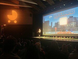
Regard (film festival)
Canadian film festival
Distance: Approx. 10 meters
Latitude and longitude: 48.40611111,-71.24777778
Regard – Saguenay International Short Film Festival (French: Festival Regard or Festival international du court métrage au Saguenay), also known as the Saguenay International Short Film Festival, or simply Regard (stylized as REGARD; lit. "Look"), is a short film festival taking place annually in the city of Saguenay, Quebec, Canada. Founded in 1996, it is one of the main film festivals dedicated to shorts in North America.

Rivière aux Sables (Saguenay River tributary)
River in Quebec, Canada
Distance: Approx. 4073 meters
Latitude and longitude: 48.44278,-71.24694
The rivière aux Sables is a river of the city of Saguenay (city), in the administrative region of Saguenay-Lac-Saint-Jean, in Quebec, in Canada. This watercourse constitutes one of the two outlets of Kenogami Lake; it flows north to flow into the Saguenay River. It is the only river that crosses Jonquière.
Rivière des Aulnaies (Saguenay River)
Watercourse in Canada
Distance: Approx. 9440 meters
Latitude and longitude: 48.47833333,-71.315
The rivière des Aulnaies is a tributary of the Saguenay River, flowing on the northwest shore of the Saint Lawrence River, successively in the municipalities of Bégin and Saint-Ambroise, in the Le Fjord-du-Saguenay Regional County Municipality, in the administrative region of Saguenay–Lac-Saint-Jean, in the Province of Quebec, in Canada. The watershed of the Aulnaies River is served by: west side: via chemin Saint-Léonard, chemin du rang Ouest, chemin du 7th rang, chemin du 5th rang, chemin du 8th rang and 2nd West range for the upper part; east side: via the rang des Aulnaies road which separates from the double range road and which becomes north the main road, the 4th range road, the 5th road range. Forestry and agriculture are the main economic activities in the watershed.
Weather in this IP's area
moderate rain
8 Celsius
6 Celsius
8 Celsius
8 Celsius
1001 hPa
95 %
1001 hPa
983 hPa
716 meters
2.82 m/s
6.85 m/s
287 degree
100 %
06:39:24
16:17:54