204.19.142.52 - IP Lookup: Free IP Address Lookup, Postal Code Lookup, IP Location Lookup, IP ASN, Public IP
Country:
Region:
City:
Location:
Time Zone:
Postal Code:
ISP:
ASN:
language:
User-Agent:
Proxy IP:
Blacklist:
IP information under different IP Channel
ip-api
Country
Region
City
ASN
Time Zone
ISP
Blacklist
Proxy
Latitude
Longitude
Postal
Route
db-ip
Country
Region
City
ASN
Time Zone
ISP
Blacklist
Proxy
Latitude
Longitude
Postal
Route
IPinfo
Country
Region
City
ASN
Time Zone
ISP
Blacklist
Proxy
Latitude
Longitude
Postal
Route
IP2Location
204.19.142.52Country
Region
quebec
City
longueuil
Time Zone
America/Montreal
ISP
Language
User-Agent
Latitude
Longitude
Postal
ipdata
Country
Region
City
ASN
Time Zone
ISP
Blacklist
Proxy
Latitude
Longitude
Postal
Route
Popular places and events near this IP address

Longueuil
City in Quebec, Canada
Distance: Approx. 2311 meters
Latitude and longitude: 45.53333333,-73.51666667
Longueuil (French pronunciation: [lɔ̃ɡœj] ) is a city in the province of Quebec, Canada. It is the seat of the Montérégie administrative region and the central city of the urban agglomeration of Longueuil. It sits on the south shore of the Saint Lawrence River directly across from Montreal.

Cégep Édouard-Montpetit
Public college in Longueuil, Quebec
Distance: Approx. 961 meters
Latitude and longitude: 45.53527778,-73.49416667
Cégep Édouard-Montpetit (French pronunciation: [seʒɛp edwaʁ mɔ̃tpəti]) is a public Francophone college in Longueuil, Quebec, Canada. Approximately 7,300 (fall 2016) students (as much in the Continuing Education programs) are enrolled in the 2 campuses, the main one located in Longueuil and the École nationale d'aérotechnique in St-Hubert campuses.

Montreal Quebec Temple
Church building in Quebec, Canada
Distance: Approx. 2197 meters
Latitude and longitude: 45.563335,-73.490616
The Montreal Quebec Temple is the 86th operating temple of the Church of Jesus Christ of Latter-day Saints (LDS Church).
Roman Catholic Diocese of Saint-Jean–Longueuil
Catholic ecclesiastical territory
Distance: Approx. 1367 meters
Latitude and longitude: 45.54027778,-73.50777778
The Roman Catholic Diocese of Saint-Jean–Longueuil (Latin: Dioecesis Sancti Ioannis–Longoliensis) is a suffragan of the Metropolitan Archdiocese of Montréal in (mostly francophone) Québec, southeastern Canada. Its cathedral episcopal see is the Cathédrale Saint-Jean-l’Évangéliste dedicated to John the Evangelist, in Saint-Jean-sur-Richelieu. It has a Co-Cathedral: Cocathédrale Saint-Antoine-de-Padoue, dedicated to Saint Anthony of Padua, in Longueuil, Québec, and a Minor basilica: Basilique Sainte-Anne-de-Varennes, in Varennes, Québec.
Service de sécurité incendie de l'agglomération de Longueuil
Distance: Approx. 2311 meters
Latitude and longitude: 45.53333333,-73.51666667
Service de sécurité incendie de l'agglomération de Longueuil (French pronunciation: [sɛʁvis də sekyʁite ɛ̃sɑ̃di də laɡlɔmeʁasjɔ̃ də lɔ̃ɡœj], SSIAL) is responsible for fire and rescue operations in Longueuil, Brossard, Saint-Lambert, Saint-Bruno-de-Montarville and Boucherville, Quebec, Canada.
Ville Jacques-Cartier
City in the South Shore of Montreal
Distance: Approx. 1286 meters
Latitude and longitude: 45.53333333,-73.48333333
Ville Jacques-Cartier (French pronunciation: [vil ʒak kaʁtje]) was a city located on the south shore of Montreal, Quebec, Canada. It was named after the founder of New France, Jacques Cartier. Now a defunct municipality, its former territory makes up about a quarter of the current city of Longueuil and 80% of Le Vieux-Longueuil borough.

Old Longueuil
Neighbourhood of Longueuil, Quebec
Distance: Approx. 1727 meters
Latitude and longitude: 45.5374,-73.5112
Old Longueuil (French: Vieux-Longueuil) is a historic neighbourhood located in the borough of the same name, in the city of Longueuil, Quebec, Canada. The neighbourhood essentially corresponds to the pre-1961 city of Longueuil and is bordered to the west by Joliette street, north by Saint Lawrence River and east by d'Augerne street, while its southern limits varies from one source to another but can go as far as De Gentilly street in some definitions Old Longueuil was named a heritage district by the city in 1993, and features 450 buildings built before 1945. Many historic buildings are found in this district, such as the Co-Cathedral of Saint-Antoine-de-Padoue, the ruins of Fort Longueuil, and Saint Mark's Anglican Church.

Co-Cathedral of Saint-Antoine-de-Padoue
Church in Quebec, Canada
Distance: Approx. 1378 meters
Latitude and longitude: 45.540289,-73.507931
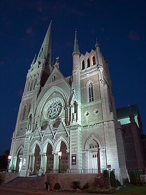
The Co-Cathedral of Saint-Antoine-de-Padoue (French: Co-cathédrale Saint-Antoine-de-Padoue) is a co-cathedral in Longueuil, Quebec, Canada, on Montreal's south shore. It is located on the corner of Rue Saint-Charles and Chemin Chambly in the Borough of Le Vieux-Longueuil. It is dedicated to St.

Fort Longueuil
Distance: Approx. 1394 meters
Latitude and longitude: 45.540518,-73.508223
Fort Longueuil was a stone fort that stood in Longueuil, in Quebec, Canada from 1690 to 1810. Fort Longueuil was recognized as a National Historic Site of Canada on May 25, 1923. The historic site includes the archaeological site of the fort, which was demolished in 1810.

Parc Michel-Chartrand
Park in Quebec, Canada
Distance: Approx. 1749 meters
Latitude and longitude: 45.547,-73.469
Parc Michel-Chartrand, formerly known as the Parc régional de Longueuil, is a large park located in Longueuil, Quebec, Canada. It is located at 1895 Rue Adoncour in the borough of Le Vieux-Longueuil. It is 1,850,000 square metres (19,900,000 sq ft) in area.

New Life Church (Canada)
Church in Longueuil, Canada
Distance: Approx. 760 meters
Latitude and longitude: 45.54777778,-73.49861111
New Life church (French: Église Nouvelle vie) is an Evangelical Pentecostal multi-site megachurch based in Longueuil, Quebec, Canada, affiliated with the Christian Association for the Francophonie. Its senior pastor is Claude Houde.
Montréal/Hydro Aéroport de Montréal Water Airport
Airport in Longueuil, Quebec
Distance: Approx. 1903 meters
Latitude and longitude: 45.54444444,-73.51527778
Montréal/Hydro Aéroport de Montréal Water Airport (TC LID: CHA3) is a certified airport located on the Saint Lawrence River at Longueuil, 3.4 nautical miles (6.3 km; 3.9 mi) northeast of Montreal, Quebec, Canada.
Weather in this IP's area
overcast clouds
-6 Celsius
-13 Celsius
-8 Celsius
-6 Celsius
1019 hPa
65 %
1019 hPa
1016 hPa
10000 meters
5.66 m/s
8.23 m/s
260 degree
100 %