204.17.163.115 - IP Lookup: Free IP Address Lookup, Postal Code Lookup, IP Location Lookup, IP ASN, Public IP
Country:
 USA
USARegion:
City:
Location:
Time Zone:
Postal Code:
ISP:
ASN:
language:
User-Agent:
Proxy IP:
Blacklist:
IP information under different IP Channel
ip-api
Country
Region
City
ASN
Time Zone
ISP
Blacklist
Proxy
Latitude
Longitude
Postal
Route
db-ip
Country
Region
City
ASN
Time Zone
ISP
Blacklist
Proxy
Latitude
Longitude
Postal
Route
IPinfo
Country
Region
City
ASN
Time Zone
ISP
Blacklist
Proxy
Latitude
Longitude
Postal
Route
IP2Location
204.17.163.115Country
usRegion
rhode island
City
cranston
Time Zone
America/New_York
ISP
Language
User-Agent
Latitude
Longitude
Postal
ipdata
Country
Region
City
ASN
Time Zone
ISP
Blacklist
Proxy
Latitude
Longitude
Postal
Route
Popular places and events near this IP address

Cranston, Rhode Island
City in Rhode Island, United States
Distance: Approx. 1143 meters
Latitude and longitude: 41.76666667,-71.45
Cranston, formerly known as Pawtuxet, is a city in Providence County, Rhode Island, United States. The official population of the city in the 2020 United States Census was 82,934, making it the second-largest city in the state. The center of population of Rhode Island is located in Cranston.

Cranston School District
School district in Rhode Island, United States
Distance: Approx. 1091 meters
Latitude and longitude: 41.7727,-71.46288
Cranston School District is a school district located in Cranston, Rhode Island, USA, which services an approximate student population of 11,155 in pre-kindergarten through twelfth grade. With 790 full-time classroom teachers, the district's overall student/teacher ratio is 14.1:1. There are 24 schools associated with the agency, which is classified as being in or near a mid-sized city (Cranston, RI).
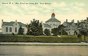
Howard, Rhode Island
Distance: Approx. 1891 meters
Latitude and longitude: 41.74666667,-71.45611111
Howard was originally a farming hamlet in the southern part of Cranston, Rhode Island. In the mid-19th century, most of the land was acquired by the State of Rhode Island to construct a state prison, a poor house, and other state facilities. The Rhode Island State Prison, designed by prison reformer John Haviland was first built in 1878, and is a stark and imposing gothic structure built of granite block.
Meshanticut, Rhode Island
Distance: Approx. 657 meters
Latitude and longitude: 41.76666667,-71.46888889
Meshanticut is a neighborhood in Cranston, Rhode Island, United States. Meshanticut is a residential neighborhood on the western side of Cranston. Meshanticut, which is a Narragansett Indian word meaning "place of woods" features an eclectic array of housing styles including Victorian homes, cottages, and capes.

Cranston High School West
Public high school in the United States
Distance: Approx. 1512 meters
Latitude and longitude: 41.77194444,-71.47638889
Cranston High School West (often called West, Cranston West or abbreviated as CHSW) is a public high school located in Cranston, Rhode Island, United States. The school comprises five buildings; one of these buildings is the Cranston Area Career and Technical Center. The school grounds include six tennis courts, a baseball field, and a track and football field.

Westcote (Cranston, Rhode Island)
Historic house in Rhode Island, United States
Distance: Approx. 1170 meters
Latitude and longitude: 41.75527778,-71.4725
Westcote is a historic house in Cranston, Rhode Island. This 1+1⁄2-story Greek Revival cottage was built c. 1843, and was originally located on Oaklawn Avenue before being moved to its present location.
Eleanor Slater Hospital
Hospital in Rhode Island, United States
Distance: Approx. 1999 meters
Latitude and longitude: 41.744945,-71.462648
The Eleanor Slater Hospital is Rhode Island's state psychiatric hospital with campuses at the John O. Pastore Center at 111 Howard Avenue in Cranston, Rhode Island and the Zambarano division at Wallum Lake in Burrillville, Rhode Island.
Alex and Ani
Jewelry company
Distance: Approx. 906 meters
Latitude and longitude: 41.75538889,-71.45861111
Alex and Ani is an American retailer and producer of jewelry located in Cranston, Rhode Island.
Rhode Island Maximum Security Prison
Distance: Approx. 1891 meters
Latitude and longitude: 41.746667,-71.456111
Rhode Island Maximum Security Prison, formerly known as Howard Prison, is a Rhode Island Department of Corrections state prison for men located in Cranston, Rhode Island. It is the state's oldest operational prison, with a current capacity of 430. The facility was first completed in 1878 as the State Prison and Providence County Jail.
John J. Moran Medium Security Facility
Prison in Rhode Island, US
Distance: Approx. 2019 meters
Latitude and longitude: 41.744899,-71.465805
The John J. Moran Medium Security Facility is a medium-security state men's prison in Cranston, Rhode Island, owned and operated by the Rhode Island Department of Corrections. The facility opened in 1992, and has an operational capacity of 1006 prisoners.
Anthony P. Travisono Intake Service Center
Distance: Approx. 1590 meters
Latitude and longitude: 41.748645,-71.463972
The Anthony P. Travisono Intake Service Center is a maximum-security state men's prison in Cranston, Rhode Island, owned and operated by the Rhode Island Department of Corrections. The facility opened in 1985, and has an operational capacity of 1118 prisoners.

Cranston Public Library
Public library system in Rhode Island, US
Distance: Approx. 1066 meters
Latitude and longitude: 41.754378,-71.456945
The Cranston Public Library is the public library system serving Cranston, the second largest city in Rhode Island. The first library in Cranston was formed in 1797, while the library system was formed in 1966 by the Cranston City Council. The present day library system formed in 1968 when six independent neighborhood libraries came together as one.
Weather in this IP's area
clear sky
-9 Celsius
-16 Celsius
-10 Celsius
-8 Celsius
1034 hPa
52 %
1034 hPa
1026 hPa
10000 meters
6.69 m/s
340 degree