204.16.249.106 - IP Lookup: Free IP Address Lookup, Postal Code Lookup, IP Location Lookup, IP ASN, Public IP
Country:
Region:
City:
Location:
Time Zone:
Postal Code:
IP information under different IP Channel
ip-api
Country
Region
City
ASN
Time Zone
ISP
Blacklist
Proxy
Latitude
Longitude
Postal
Route
Luminati
Country
Region
mi
City
rochester
ASN
Time Zone
America/Detroit
ISP
CARETECH-SOLUTIONS
Latitude
Longitude
Postal
IPinfo
Country
Region
City
ASN
Time Zone
ISP
Blacklist
Proxy
Latitude
Longitude
Postal
Route
IP2Location
204.16.249.106Country
Region
indiana
City
elkhart
Time Zone
America/Indiana/Indianapolis
ISP
Language
User-Agent
Latitude
Longitude
Postal
db-ip
Country
Region
City
ASN
Time Zone
ISP
Blacklist
Proxy
Latitude
Longitude
Postal
Route
ipdata
Country
Region
City
ASN
Time Zone
ISP
Blacklist
Proxy
Latitude
Longitude
Postal
Route
Popular places and events near this IP address
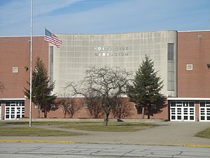
North Side Gymnasium
Arena in Indiana, United States
Distance: Approx. 910 meters
Latitude and longitude: 41.701748,-85.975463
The North Side Gymnasium is a 7,373 seat multi-purpose arena opened in 1954 located in Elkhart, Indiana, United States on the campus of North Side Middle School. Elkhart High School, hosts their varsity boys' basketball games along with other varsity sports such as volleyball and wrestling. It was home to the Elkhart Express of the International Basketball League.

Elkhart River
River
Distance: Approx. 2008 meters
Latitude and longitude: 41.6916667,-85.9722222
The Elkhart River is a 48.3-mile-long (77.7 km) tributary of the St. Joseph River in northern Indiana in the United States. It is almost entirely contained in Elkhart County.

Osolo Township, Elkhart County, Indiana
Township in Indiana, United States
Distance: Approx. 2747 meters
Latitude and longitude: 41.72416667,-85.94611111
Osolo Township is one of sixteen townships in Elkhart County, Indiana. As of the 2010 census, its population was 28,032.

Ruthmere Mansion
Historic house in Indiana, United States
Distance: Approx. 1822 meters
Latitude and longitude: 41.69333333,-85.97333333
Ruthmere, formerly the Albert and Elizabeth Beardsley Residence, is a three-story Beaux-Arts mansion that is the most prominent historic residence in Elkhart, Indiana, United States. Built in 1910, the Ruthmere Mansion is now open to the public as a museum, along with the neighboring Dr. Havilah Beardsley House.

Dr. Havilah Beardsley House
Historic house in Indiana, United States
Distance: Approx. 1836 meters
Latitude and longitude: 41.69361111,-85.97777778
Dr. Havilah Beardsley House is a historic home located at Elkhart, Elkhart County, Indiana. It was built in 1848, and is a two-story, rectangular, Italianate style brick dwelling.

Emmanuel C. Bickel House
Historic house in Indiana, United States
Distance: Approx. 2499 meters
Latitude and longitude: 41.68888889,-85.98416667
Emmanuel C. Bickel House is a historic home located at Elkhart, Elkhart County, Indiana. It was built about 1870, and is a two-story, "T"-plan, Carpenter Gothic style balloon frame dwelling. It features a wraparound porch with a flat roof, decorative scrollwork, and eight bracketed square columns.: 5 It was added to the National Register of Historic Places in 1979.

Mark L. and Harriet E. Monteith House
Historic house in Indiana, United States
Distance: Approx. 1847 meters
Latitude and longitude: 41.69472222,-85.96333333
Mark L. and Harriet E. Monteith House was a historic home located at Elkhart, Elkhart County, Indiana. It was built around 1908, and was a two-story, T-shaped, frame dwelling which was remodeled in the Tudor Revival style in the 1930s. It featured a steeply pitched roof, two-story porch, and brick and half-timbering on the exterior.: 2 It has been demolished.
Green Block
United States historic place
Distance: Approx. 2596 meters
Latitude and longitude: 41.68638889,-85.97222222
Green Block, also known as the Smith Frye Building, is a historic commercial building located in Elkhart, Elkhart County, Indiana. It was built in 1895, and is a two-story, eclectic Italianate style brick commercial building. It features projecting pressed metal bays above each storefront and at the corners and arched second story openings with balconies.: 2 It was added to the National Register of Historic Places in 1980.
Young Women's Christian Association (Elkhart, Indiana)
United States historic place
Distance: Approx. 2596 meters
Latitude and longitude: 41.68638889,-85.97388889
Young Women's Christian Association, also known as the Elkhart Y.W.C.A. and Lexington House, is a historic YWCA located at Elkhart, Elkhart County, Indiana. It was built in 1919, and is a three-story, brick building on a raised basement and Bungalow / American Craftsman style design elements. It measures approximately 40 feet wide and 150 feet deep.

Beardsley Avenue Historic District
Historic district in Indiana, United States
Distance: Approx. 1956 meters
Latitude and longitude: 41.69222222,-85.97527778
Beardsley Avenue Historic District is a national historic district located at Elkhart, Elkhart County, Indiana. The district encompasses 41 contributing buildings, 3 contributing sites, 2 contributing structures, and 2 contributing objects in a predominantly residential section of Elkhart. It was developed after 1848, and includes residences in a number of architectural styles including Prairie School and Beaux Arts.
Elkhart Downtown Commercial Historic District
Historic district in Indiana, United States
Distance: Approx. 2813 meters
Latitude and longitude: 41.68444444,-85.97166667
Elkhart Downtown Commercial Historic District is a national historic district located at Elkhart, Elkhart County, Indiana. The district encompasses 59 contributing buildings in the central business district of Elkhart. It was developed between about 1868 and 1930, and includes notable examples of Italianate, Queen Anne, and Classical Revival style architecture.

Wellfield Botanic Gardens
Botanic gardens in Elkhart, Indiana, U.S.
Distance: Approx. 1594 meters
Latitude and longitude: 41.6964,-85.98
Wellfield Botanic Gardens, located in Elkhart, Indiana, United States, is a 36 acres (15 ha) botanical garden and a working source of hydropower and drinking water. It is a 501(c)3 not-for-profit organization funded by private donations, earned revenue, memberships, and grants.
Weather in this IP's area
overcast clouds
3 Celsius
1 Celsius
2 Celsius
3 Celsius
1029 hPa
87 %
1029 hPa
998 hPa
10000 meters
2.06 m/s
60 degree
100 %


