204.157.98.143 - IP Lookup: Free IP Address Lookup, Postal Code Lookup, IP Location Lookup, IP ASN, Public IP
Country:
Region:
City:
Location:
Time Zone:
Postal Code:
ISP:
ASN:
language:
User-Agent:
Proxy IP:
Blacklist:
IP information under different IP Channel
ip-api
Country
Region
City
ASN
Time Zone
ISP
Blacklist
Proxy
Latitude
Longitude
Postal
Route
db-ip
Country
Region
City
ASN
Time Zone
ISP
Blacklist
Proxy
Latitude
Longitude
Postal
Route
IPinfo
Country
Region
City
ASN
Time Zone
ISP
Blacklist
Proxy
Latitude
Longitude
Postal
Route
IP2Location
204.157.98.143Country
Region
washington
City
federal way
Time Zone
America/Los_Angeles
ISP
Language
User-Agent
Latitude
Longitude
Postal
ipdata
Country
Region
City
ASN
Time Zone
ISP
Blacklist
Proxy
Latitude
Longitude
Postal
Route
Popular places and events near this IP address

Lakeland North, Washington
Census-designated place in Washington, United States
Distance: Approx. 2841 meters
Latitude and longitude: 47.33694444,-122.28166667
Lakeland North is a census-designated place (CDP) in King County, Washington, United States. The population was 13,663 at the 2020 census. Part of the community was annexed into neighboring Auburn in 2008.
Federal Way Public Schools
School district in Washington, United States
Distance: Approx. 2156 meters
Latitude and longitude: 47.304858,-122.324696
Federal Way Public Schools is a school district in King County, Washington covering all of Federal Way and portions of Kent, Des Moines, Auburn, and unincorporated census-designated places Lakeland North and Lakeland South, encompassing 35 square miles (91 km2).

Bubbleator
Distance: Approx. 2756 meters
Latitude and longitude: 47.344677,-122.328542
The Bubbleator was a large, bubble-shaped hydraulic elevator with transparent acrylic glass walls operated from an elevated chair built for the 1962 World's Fair in Seattle. These transparent walls gave the illusion of looking through an actual 'soap bubble' by refracting light to obtain a rainbow-like effect for the riders inside. It was originally part of the Washington State Coliseum (now a sports venue known as Climate Pledge Arena), where it lifted 100 passengers at a time up one floor through a structure of interlocking aluminum cubes to the "World of Tomorrow" exhibit.

Redondo, Des Moines, Washington
Distance: Approx. 2937 meters
Latitude and longitude: 47.348,-122.322
Redondo is a community within the incorporated boundaries of the city of Des Moines in King County, Washington. Redondo was initially founded as a resort, but gradually grew to be a middle-class residential community. The community, which is largely centered on Redondo Beach – a small beach with a board-walk, a Salty's restaurant, and a pay parking lot, was reportedly named by a settler from Redondo Beach, California.

The Commons at Federal Way
Shopping mall in Washington, US
Distance: Approx. 1053 meters
Latitude and longitude: 47.31333333,-122.30861111
The Commons at Federal Way (formerly SeaTac Mall) is a regional shopping mall located in Federal Way, Washington, and is the only indoor shopping center in the city. Steadfast Commercial Properties changed the mall's name to The Commons at Federal Way in November 2003 as part of a redevelopment program. The previous name had been confusing due to the later incorporation of SeaTac as a separate city.

Federal Way High School
Public school in Federal Way, Washington, United States
Distance: Approx. 560 meters
Latitude and longitude: 47.32722222,-122.31472222
Federal Way High School is a public high school located in Federal Way, Washington. It was originally built in 1938. A new campus opened in the fall of 2016.

Federal Way Downtown station
Transit center in Federal Way, Washington
Distance: Approx. 807 meters
Latitude and longitude: 47.3175,-122.30472222
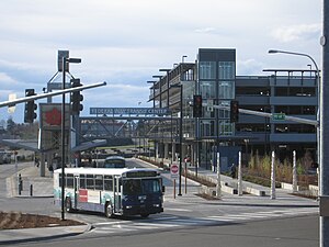
Federal Way Downtown is a future light rail station at the site of the Federal Way Transit Center, a bus station in Federal Way, Washington. The bus station opened in 2006 and has 1,190 parking spaces available in its parking garage and surface lots. It is served by King County Metro, Pierce Transit and Sound Transit Express buses and is the southern terminus of the RapidRide A Line.

Harry S. Truman High School (Federal Way)
High school in Washington, U.S.
Distance: Approx. 1086 meters
Latitude and longitude: 47.3192,-122.299
Harry S. Truman High School is a high school located in Federal Way, Washington, United States. It's part of the Federal Way Public Schools District.

Washington's 30th legislative district
Distance: Approx. 2512 meters
Latitude and longitude: 47.3,-122.31666667
Washington's 30th legislative district is one of forty-nine districts in Washington state for representation in the state legislature. It is mostly in King County with a small section in Pierce County. It covers the cities of Federal Way, Des Moines, Auburn, Algona, Pacific, and Milton, as well as unincorporated parts of King County.
Celebration Park, Federal Way
Park in Federal Way, Washington
Distance: Approx. 1803 meters
Latitude and longitude: 47.307,-122.32
Celebration Park is the largest and most frequented park in Federal Way, Washington. The park is 83.5 acres and contains a children's play structure, four lighted baseball fields, four lighted soccer fields and trails and pathways connecting to the BPA Trail. It also includes a community center.
Steel Lake (Washington)
Lake in Federal Way, Washington
Distance: Approx. 928 meters
Latitude and longitude: 47.327524,-122.302893
Steel Lake is a lake located in the city of Federal Way in southern King County, Washington, United States. Steel Lake Park is located on its southern shore. Interstate 5 is located just to the east of the lake, and Lake Dolloff is located on the other side of I-5.

Lake Dolloff
Lake in King County, Washington
Distance: Approx. 2001 meters
Latitude and longitude: 47.325218,-122.286404
Lake Dolloff is located in southern King County, Washington in the Lakeland North census-designated place. It is one of two large lakes in Lakeland North, alongside Star Lake. Interstate 5 runs just to the west of the lake, and Steel Lake is located on the other side of I-5.
Weather in this IP's area
clear sky
-1 Celsius
-1 Celsius
-1 Celsius
-1 Celsius
1030 hPa
86 %
1030 hPa
1021 hPa
10000 meters
0.29 m/s
0.44 m/s
41 degree
10 %