204.153.131.65 - IP Lookup: Free IP Address Lookup, Postal Code Lookup, IP Location Lookup, IP ASN, Public IP
Country:
 USA
USARegion:
City:
Location:
Time Zone:
Postal Code:
ISP:
ASN:
language:
User-Agent:
Proxy IP:
Blacklist:
IP information under different IP Channel
ip-api
Country
Region
City
ASN
Time Zone
ISP
Blacklist
Proxy
Latitude
Longitude
Postal
Route
db-ip
Country
Region
City
ASN
Time Zone
ISP
Blacklist
Proxy
Latitude
Longitude
Postal
Route
IPinfo
Country
Region
City
ASN
Time Zone
ISP
Blacklist
Proxy
Latitude
Longitude
Postal
Route
IP2Location
204.153.131.65Country
usRegion
washington
City
sumas
Time Zone
America/Los_Angeles
ISP
Language
User-Agent
Latitude
Longitude
Postal
ipdata
Country
Region
City
ASN
Time Zone
ISP
Blacklist
Proxy
Latitude
Longitude
Postal
Route
Popular places and events near this IP address
Kendall, Washington
CDP in Washington, United States
Distance: Approx. 6903 meters
Latitude and longitude: 48.91944444,-122.1375
Kendall is a census-designated place (CDP) in Whatcom County, Washington, United States. The population was 191 at the 2010 census.

Peaceful Valley, Washington
CDP in Washington, United States
Distance: Approx. 4627 meters
Latitude and longitude: 48.94277778,-122.1475
Peaceful Valley is a census-designated place (CDP) in Whatcom County, Washington, United States, near Kendall. The population was 3,015 at the 2020 census.

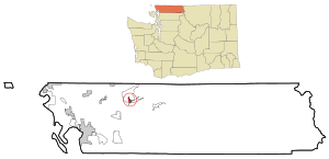
Sumas, Washington
City in Washington, United States
Distance: Approx. 6170 meters
Latitude and longitude: 49,-122.26666667
Sumas (SOO-mas) is a city in Whatcom County, Washington, United States. It had a population of 1,583 as of the 2020 census. Sumas is located adjacent to the Canada–U.S. border and borders the city of Abbotsford, British Columbia.

Sumas Mountain
Mountain in United States of America
Distance: Approx. 6222 meters
Latitude and longitude: 48.9117859,-122.2220985
Sumas Mountain is a mountain located in Whatcom County, Washington, 15 miles northeast of Bellingham and southwest of Vedder Mountain. Located in the Skagit Range, the mountain is notable for its high biodiversity and year-round hiking trails. It is sometimes referred to as American Sumas to distinguish it from an identically named mountain across the Canada–United States border in British Columbia just 10 km (6.2 mi) to the north, both of which are drained by tributary creeks of the Sumas River.
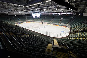
Abbotsford Centre
Multi-purpose arena in British Columbia, Canada
Distance: Approx. 9616 meters
Latitude and longitude: 49.030665,-122.287145
Abbotsford Centre, formerly Abbotsford Entertainment and Sports Centre, is a 7,000-seat multi-purpose arena in Abbotsford, British Columbia. The arena was expected to cost $64.7 million. Construction began on September 24, 2007.
Huntingdon, Abbotsford
Distance: Approx. 6170 meters
Latitude and longitude: 49,-122.26666667
Huntingdon is a community within Abbotsford, British Columbia, Canada. It is located immediately north of the Canada–US border, and is the location of the Sumas–Huntingdon Border Crossing. The main road through the community is Highway 11.
Swift Creek Landslide
Landslide in Washington state, U.S.
Distance: Approx. 7288 meters
Latitude and longitude: 48.908,-122.247
The Swift Creek Landslide is an active, slow-moving landslide located in western Washington, USA, due east of Everson on Sumas Mountain. Asbestos-laden sediment originating from the landslide has recently generated much interest in this area. Asbestos is a known carcinogen.
Nooksack Valley High School
Rural high school in Nooksack, Washington
Distance: Approx. 7844 meters
Latitude and longitude: 48.96416667,-122.3075
Nooksack Valley High School is a four-year public secondary school located in rural Whatcom County, just north of Nooksack. It is located just north of Nooksack, Washington, on E. Badger Road at the junction of State Route 9 and State Route 546. The school mascot is a Pioneer and the school colors are purple and white.
Envision Athletic Centre
Multi-purpose athletics facility in the University of the Fraser Valley, British Columbia, Canada
Distance: Approx. 9198 meters
Latitude and longitude: 49.02722222,-122.28444444
Envision Athletic Centre is a 21,500-square-foot (2,000 m2) multi-purpose athletics facility on the campus of the University of the Fraser Valley in Abbotsford, British Columbia, Canada. It opened in May 2002 and was upgraded in 2005. It hosts the university of the Fraser Valley Cascades basketball team on a basketball court that seats 1,700.
Columbia Valley (Lower Mainland)
Place in British Columbia, Canada
Distance: Approx. 9348 meters
Latitude and longitude: 49,-122.08333333
The Columbia Valley is a small valley and unincorporated settlement stretching southwest of Cultus Lake and extending across the Canada–United States border into Whatcom County, Washington. It is located to the south of the City of Chilliwack and east of Abbotsford, lying between Vedder Mountain and the main bulk of the Cascade Mountains. There is no border crossing in the valley, which has only a few farms in it.

Sumas–Huntingdon Border Crossing
Border crossing between Canada and the United States
Distance: Approx. 6275 meters
Latitude and longitude: 49.002411,-122.265511
The Sumas–Huntingdon Border Crossing connects Sumas, Washington and Abbotsford, British Columbia on the Canada–US border. Washington State Route 9 on the American side joins British Columbia Highway 11 on the Canadian side.
Castle Fun Park
Amusement park in British Columbia
Distance: Approx. 7988 meters
Latitude and longitude: 49.0221,-122.1324
Castle Fun Park is an amusement park located in Abbotsford, British Columbia, by the Trans-Canada Highway. The park is built like a castle resembling medieval architecture and includes many attractions and arcade games. The park is currently run by the Wiebe family.
Weather in this IP's area
clear sky
-1 Celsius
-3 Celsius
-3 Celsius
0 Celsius
1027 hPa
42 %
1027 hPa
1000 hPa
10000 meters
1.34 m/s
3.13 m/s
356 degree