204.152.176.170 - IP Lookup: Free IP Address Lookup, Postal Code Lookup, IP Location Lookup, IP ASN, Public IP
Country:
Region:
City:
Location:
Time Zone:
Postal Code:
ISP:
ASN:
language:
User-Agent:
Proxy IP:
Blacklist:
IP information under different IP Channel
ip-api
Country
Region
City
ASN
Time Zone
ISP
Blacklist
Proxy
Latitude
Longitude
Postal
Route
db-ip
Country
Region
City
ASN
Time Zone
ISP
Blacklist
Proxy
Latitude
Longitude
Postal
Route
IPinfo
Country
Region
City
ASN
Time Zone
ISP
Blacklist
Proxy
Latitude
Longitude
Postal
Route
IP2Location
204.152.176.170Country
Region
pennsylvania
City
devon
Time Zone
America/New_York
ISP
Language
User-Agent
Latitude
Longitude
Postal
ipdata
Country
Region
City
ASN
Time Zone
ISP
Blacklist
Proxy
Latitude
Longitude
Postal
Route
Popular places and events near this IP address
Devon-Berwyn, Pennsylvania
Former census-designated place in Pennsylvania, United States
Distance: Approx. 1041 meters
Latitude and longitude: 40.04361111,-75.43611111
Devon-Berwyn was a census-designated place (CDP) in Chester County, Pennsylvania. The population was 5,067 at the 2000 census. For the 2010 census, the area was split into two separate CDPs, Devon and Berwyn.
Easttown Township, Pennsylvania
Township in Pennsylvania, United States
Distance: Approx. 1593 meters
Latitude and longitude: 40.03555556,-75.43944444
Easttown Township is a township in Chester County, Pennsylvania, United States. The population was 10,984 at the 2020 census. The township, which lies in the western half of Philadelphia's Main Line suburbs, comprises predominantly parts of two unincorporated areas: Devon and Berwyn.

Berwyn, Pennsylvania
Census-designated place in Pennsylvania, United States
Distance: Approx. 1344 meters
Latitude and longitude: 40.04555556,-75.43944444
Berwyn is a census-designated place (CDP) in Chester County, Pennsylvania, United States. Berwyn is located in Tredyffrin and Easttown townships. The area is part of the Philadelphia Main Line suburbs.

Devon, Pennsylvania
Census-designated place in Pennsylvania, United States
Distance: Approx. 707 meters
Latitude and longitude: 40.04972222,-75.42555556
Devon is a census-designated place (CDP) located in Easttown township in Chester County, Pennsylvania, United States. The population was 1,515 at the 2010 census. The area is part of the Philadelphia Main Line suburbs.

Strafford station
Distance: Approx. 1843 meters
Latitude and longitude: 40.0496,-75.4038
Strafford station is a commuter rail station located in the western suburbs of Philadelphia at Old Eagle School Road and Crestline Road, in Tredyffrin Township, and it is served by most Paoli/Thorndale Line trains. The ticket office at this station is open weekdays from 5:50 a.m. to 1:15 p.m., excluding holidays.

Devon station
Distance: Approx. 422 meters
Latitude and longitude: 40.0472,-75.4228
Devon station is a commuter rail station located in the western suburbs of Philadelphia at 98 North Devon Boulevard and Lancaster Avenue in Devon, Pennsylvania, United States. It is served by most Paoli/Thorndale Line trains. Devon station was originally built by the Pennsylvania Railroad and opened in 1883.

Berwyn station (SEPTA)
Distance: Approx. 1687 meters
Latitude and longitude: 40.048,-75.4428
Berwyn station is a commuter rail station in Berwyn, Pennsylvania, United States, served by SEPTA Regional Rail. Located at Cassatt Avenue and Lancaster Pike, it provides service to the western suburbs of Philadelphia. Most Paoli/Thorndale Line trains run through the station.

Strafford, Pennsylvania
Unincorporated community in Pennsylvania, United States
Distance: Approx. 1848 meters
Latitude and longitude: 40.05083333,-75.40444444
Strafford is an unincorporated community in the southeastern part of the U.S. state of Pennsylvania, located partly in Tredyffrin Township, Chester County, and partly in Radnor Township, Delaware County. It is served by its own stop on the SEPTA Paoli/Thorndale Line regional rail train. The SEPTA station at Strafford is one of the few buildings that survives from the 1876 Centennial Exposition at Philadelphia.

Devon Preparatory School
School in Tredyffrin Township, , Chester County, Pennsylvania, United States
Distance: Approx. 1332 meters
Latitude and longitude: 40.05527778,-75.42111111
Devon Preparatory School is a Catholic all-male college preparatory school in Tredyffrin Township, Pennsylvania, in the United States, with a Devon postal address. Founded in 1956 by Piarists, it is divided into a middle school (grades 6–8) and an upper school (grades 9–12), both located on the same 20 acres (8.1 ha) campus. The school operates independently under the auspices of the Roman Catholic Archdiocese of Philadelphia.
Roughwood (Easttown Township, Pennsylvania)
Historic house in Pennsylvania, United States
Distance: Approx. 689 meters
Latitude and longitude: 40.04944444,-75.42166667
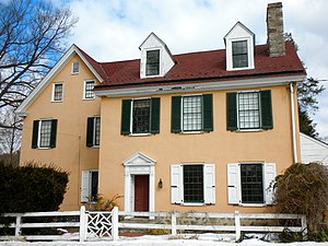
Roughwood, originally known as Lamb's Tavern, is an historic, American home that is located in Devon, Easttown Township, Chester County, Pennsylvania. It was added to the National Register of Historic Places in 1984.
Cramond (Strafford, Pennsylvania)
Historic house in Pennsylvania, United States
Distance: Approx. 1886 meters
Latitude and longitude: 40.05027778,-75.40361111
Cramond is a historic home located in Tredyffrin Township, Chester County, Pennsylvania. It was designed by the architectural firm of McKim, Mead & White in the Classical Revival style. It was built in 1886, and is a 2+1⁄2-story, six-bay half-timbered dwelling sided in clapboard.

Mount Zion A.M.E. Church (Tredyffrin Township, Pennsylvania)
United States historic place
Distance: Approx. 1678 meters
Latitude and longitude: 40.056347,-75.434208
Mount Zion A.M.E. Church is a historic African American church in Tredyffrin Township, Chester County, Pennsylvania. Built in 1880 and expanded in 1906, Mount Zion was listed on the National Register of Historic Places on January 27, 2015. It was an important community gathering place for African Americans battling racial segregation of local schools in the 1930s.
Weather in this IP's area
clear sky
2 Celsius
-3 Celsius
1 Celsius
3 Celsius
1019 hPa
39 %
1019 hPa
1006 hPa
10000 meters
5.14 m/s
260 degree


