Country:
 Canada
Region:
City:
Latitude and Longitude:
Time Zone:
Postal Code:
IP information under different IP Channel
ip-api
Country
Region
City
ASN
Time Zone
ISP
Blacklist
Proxy
Latitude
Longitude
Postal
Route
IPinfo
Country
Region
City
ASN
Time Zone
ISP
Blacklist
Proxy
Latitude
Longitude
Postal
Route
MaxMind
Country
Region
City
ASN
Time Zone
ISP
Blacklist
Proxy
Latitude
Longitude
Postal
Route
Luminati
Country
CAASN
Time Zone
America/Toronto
ISP
WHIP
Latitude
Longitude
Postal
db-ip
Country
Region
City
ASN
Time Zone
ISP
Blacklist
Proxy
Latitude
Longitude
Postal
Route
ipdata
Country
Region
City
ASN
Time Zone
ISP
Blacklist
Proxy
Latitude
Longitude
Postal
Route
Popular places and events near this IP address

Red Hill Valley
Valley in Ontario, Canada
Distance: Approx. 1655 meters
Latitude and longitude: 43.2234,-79.7981
Red Hill Valley is a valley in eastern and south-eastern Hamilton, Ontario, Canada. The valley is named after and home to the Red Hill Creek, which flows 7 kilometres (4.3 mi) north-east from Albion Falls on the Niagara Escarpment, before bending north-west near the Queen Elizabeth Way and discharging into Hamilton Harbour at Windermere Basin. The name of the area comes from the reddish soil, rich with iron.

Albion Falls
Waterfall in Hamilton, Ontario
Distance: Approx. 1941 meters
Latitude and longitude: 43.2004722,-79.8196778
Albion Falls is a 19 m (62 ft) classical/cascade waterfall flowing down the Niagara Escarpment in Red Hill Valley, in Hamilton, Ontario, Canada. With cascade falls the downpour is staggered into a series of steps causing water to "cascade". The top of the falls are located on Mountain Brow Blvd.
Bernie Arbour Memorial Stadium
Baseball stadium in Hamilton, Ontario
Distance: Approx. 823 meters
Latitude and longitude: 43.21127778,-79.82177778
Bernie Arbour Memorial Stadium is a stadium on Upper Kenilworth Avenue in Hamilton, Ontario, Canada. Located in Mohawk Sports Park, it is primarily used for baseball and was once the home of the minor league Hamilton Redbirds of the New York–Penn League. Built in 1970 when Civic Stadium was renovated to football only, it is named for former Hamilton Police Sergeant Bernie Arbour, who was the director of the Hamilton Police Minor Athletic Association from 1948 to his death in 1967.
Mount Albion, Ontario
Village in Ontario, Canada
Distance: Approx. 1824 meters
Latitude and longitude: 43.21678,-79.79456
Mount Albion was a village located in the County of Wentworth. It was situated near Albion Falls at the north end of the Red Hill Creek Valley, in what is now east Hamilton, Ontario. Mount Albion was an important community in its area throughout the 19th century, as it featured a grist mill, blacksmith shops, taverns, a church and a general store.
Mohawk Sports Park
Distance: Approx. 1009 meters
Latitude and longitude: 43.209,-79.82
Mohawk Sports Park, is a large park on the east mountain of Hamilton, Ontario, 1100 Mohawk Road East, also known as Commonwealth Park and Upper King's Forest Park.
Sir Winston Churchill Secondary School (Hamilton, Ontario)
Secondary school in Hamilton, Ontario, Canada
Distance: Approx. 2855 meters
Latitude and longitude: 43.237588,-79.794613
Sir Winston Churchill Secondary School is a Canadian secondary school located in Hamilton, Ontario. It is a member of the Hamilton-Wentworth District School Board. The school's mission statement is "Educating students to become lifelong learners and contributing citizens in a challenging, changing, multi-cultural world." Apart from the standard course offerings, the school provides special education classes and an ESL program.

Mohawk 4 Ice Centre
Distance: Approx. 925 meters
Latitude and longitude: 43.20949,-79.81706
Mohawk 4 Ice Centre is a recreation complex located in Mohawk Sports Park on Mountain Brow Boulevard near Mohawk Road East in Hamilton, Ontario, Canada. At over 136,000 square feet (12,600 m2), The Mohawk 4 Ice Centre includes 4 NHL sized ice pads, a total of twenty-four change rooms, a large multi-purpose room, sports retail outlet, offices, administration and food and beverage facilities on both floors. A conservative estimate of attendance in a single season of use for The Mohawk 4 Ice Centre is over 1,500,000 attendees.

St. Naum of Ohrid Macedonian Orthodox Church (Hamilton, Ontario)
Church in Ontario, Canada
Distance: Approx. 2778 meters
Latitude and longitude: 43.1982,-79.8382
St. Naum of Ohrid (Macedonian: Свети Наум Охридски) is a Macedonian Orthodox Church located in Hamilton, Ontario, Canada.

Sherwood Secondary School
School in Canada
Distance: Approx. 1205 meters
Latitude and longitude: 43.22764,-79.8232
Sherwood Secondary School is a secondary school in Hamilton, Ontario. It is operated by the Hamilton-Wentworth District School Board. The school opened in 1967.
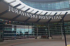
Juravinski Hospital
Hospital in Ontario, Canada
Distance: Approx. 3318 meters
Latitude and longitude: 43.23972222,-79.84472222
The Juravinski Hospital is a hospital in Hamilton, Ontario, Canada operated by Hamilton Health Sciences. It is located adjacent to the Juravinski Cancer Centre. The hospital was ranked 2nd in Canada for research according to Research Infosource Inc.

Gage Park, Hamilton
Park in Hamilton, Ontario
Distance: Approx. 2877 meters
Latitude and longitude: 43.2422,-79.8287
Gage Park is a large community park and civic gardens located in Hamilton, Ontario, Canada. It is located at the intersection of Main Street and Gage Avenue in East Hamilton. Gage Park is the usual site of gay pride in this part of the city.

Saint Nicholas Serbian Orthodox Cathedral (Hamilton, Ontario)
Church in Hamilton, Ontario
Distance: Approx. 3426 meters
Latitude and longitude: 43.2239,-79.7756
The Saint Nicholas Serbian Orthodox Cathedral (Serbian: Српски Православни Саборни Храм Светог Оца Николаја, romanized: Srpski Pravoslavni Saborni Hram Svetog Oca Nikolaja) is a Serbian Orthodox cathedral located at 149 Nash Road South, Hamilton, Ontario, Canada. It is dedicated to Saint Nicholas. Nearby, on Barton Street, there is another house of worship also named after St.
Weather in this IP's area
clear sky
9 Celsius
7 Celsius
8 Celsius
10 Celsius
1026 hPa
84 %
1026 hPa
1011 hPa
10000 meters
2.95 m/s
5.69 m/s
333 degree
1 %
07:21:36
18:53:11