Country:
 USA
USARegion:
City:
Latitude and Longitude:
Time Zone:
Postal Code:
IP information under different IP Channel
ip-api
Country
Region
City
ASN
Time Zone
ISP
Blacklist
Proxy
Latitude
Longitude
Postal
Route
IPinfo
Country
Region
City
ASN
Time Zone
ISP
Blacklist
Proxy
Latitude
Longitude
Postal
Route
MaxMind
Country
Region
City
ASN
Time Zone
ISP
Blacklist
Proxy
Latitude
Longitude
Postal
Route
Luminati
Country
USRegion
ia
City
iowacity
ASN
Time Zone
America/Chicago
ISP
IMONC
Latitude
Longitude
Postal
db-ip
Country
Region
City
ASN
Time Zone
ISP
Blacklist
Proxy
Latitude
Longitude
Postal
Route
ipdata
Country
Region
City
ASN
Time Zone
ISP
Blacklist
Proxy
Latitude
Longitude
Postal
Route
Popular places and events near this IP address
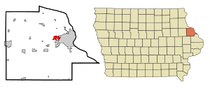
Asbury, Iowa
City in Iowa, United States
Distance: Approx. 2416 meters
Latitude and longitude: 42.51555556,-90.76333333
Asbury is a city in Dubuque County, Iowa, United States, and adjacent to the westside of the city of Dubuque. It is part of the Dubuque, Iowa Metropolitan Statistical Area. The population was 5,943 at the 2020 census.
Clarke University
Catholic university in Dubuque, Iowa, US
Distance: Approx. 3579 meters
Latitude and longitude: 42.51,-90.691
Clarke University is a private Catholic university in Dubuque, Iowa. It was founded in 1843 as St. Mary's Female Academy by Mother Mary Frances Clarke, foundress of the Sisters of Charity of the Blessed Virgin Mary.
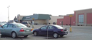
Kennedy Mall
Shopping mall in Iowa, United States
Distance: Approx. 2099 meters
Latitude and longitude: 42.494,-90.723
Kennedy Mall is a shopping mall located in Dubuque, Iowa. It is owned by the Cafaro Company. The mall's anchor stores are Edward Jones, Shoe Carnival, Planet Fitness, Vertical Jump Park, JCPenney, Dick's Sporting Goods, Ulta Beauty, and Books-A-Million.

Hempstead High School (Iowa)
Public secondary school in Dubuque, Iowa, United States
Distance: Approx. 981 meters
Latitude and longitude: 42.502,-90.734
Stephen Hempstead High School (commonly Hempstead or HHS) is a four-year public high school located in Dubuque, Iowa. It is one of two high schools in the Dubuque Community School District and enrolls around 1,800 students in grades 9–12. The school is named in honor of Stephen Hempstead, the second governor of Iowa, and it competes in class 4A of the Iowa High School Athletic Association as part of the Mississippi Valley Conference.
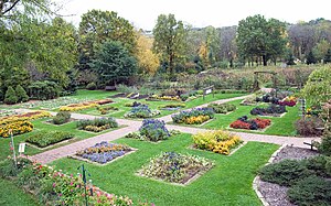
Dubuque Arboretum and Botanical Gardens
Arboretum in Dubuque, Iowa, U.S.
Distance: Approx. 2766 meters
Latitude and longitude: 42.5323,-90.7177
The Dubuque Arboretum and Botanical Gardens, or Marshall Park, is a 56 acres (230,000 m2) arboretum and botanical gardens established in 1980. The park's address is 3800 Arboretum Drive, Dubuque, Iowa. It is open, without charge, daily from dawn to dusk throughout the year.
Wahlert Catholic High School
Private secondary school in Dubuque, Iowa, United States
Distance: Approx. 2612 meters
Latitude and longitude: 42.51888889,-90.70472222
Wahlert Catholic High School is a private Roman Catholic high school in Dubuque, Iowa, United States, in the Roman Catholic Archdiocese of Dubuque.

Emmaus Bible College (Iowa)
Distance: Approx. 2355 meters
Latitude and longitude: 42.509,-90.706
Emmaus Bible College is a private Bible college in Dubuque, Iowa, affiliated with the Plymouth Brethren. It offers double majors in both professional and biblical studies. It was established as Emmaus Bible School in 1941 in Toronto, Ontario, by Ed Harlow, John Smart, and Ernest Tatham.
Center Grove, Iowa
Distance: Approx. 2705 meters
Latitude and longitude: 42.49111111,-90.71527778
Center Grove, Iowa was a town located just to the west of Dubuque, Iowa. It is located in section 27 of Dubuque Township. It is named Center as it was believed to be the center of the mining district.

Dubuque Senior High School
Public secondary school in Dubuque, Iowa, United States
Distance: Approx. 3374 meters
Latitude and longitude: 42.506,-90.694
Dubuque Senior High School (commonly Senior or DSHS) is a four-year public high school located in Dubuque, Iowa. It is one of two high schools in the Dubuque Community School District, and enrolls 1,447 students in grades 9–12. The school's mascot is the Ram; it competes at the state level in class 4A (which contains the state's largest schools) and is a member of the Mississippi Valley Athletic Conference.
Dubuque Community School District
Public school district in Dubuque, Iowa, United States
Distance: Approx. 2467 meters
Latitude and longitude: 42.511268,-90.704544
The Dubuque Community School District (DCSD) is a public school district based in Dubuque, Iowa, United States. DCSD, which operates schools in eastern Dubuque County, is the seventh largest school district in Iowa. As of the 2021-2022 school year, DCSD has 10,535 students enrolled in its schools.
Holy Family Catholic Schools
Distance: Approx. 2480 meters
Latitude and longitude: 42.518,-90.706
Holy Family Catholic Schools (HFCS) is a Roman Catholic school system based in Dubuque, Iowa (USA). Holy Family, which operates schools in eastern Dubuque County, is a part of the Roman Catholic Archdiocese of Dubuque. As of the 2011–2012 school year, HFCS has 1,837 students enrolled in its schools (excluding preschools).
KLYV
Radio station in Iowa, United States
Distance: Approx. 2426 meters
Latitude and longitude: 42.503,-90.707
KLYV (105.3 FM) is a radio station broadcasting a top 40 (CHR) format branded as Y105, serving the Dubuque, Iowa, United States, area. The station is owned by Townsquare Media and licensed to Townsquare License, LLC. The station has been a "typical" Top 40 station since 1982, and a CHR station since 1986. The station first went under the formats of MOR in the 1970s, and beautiful music beginning in 1980.
Weather in this IP's area
clear sky
29 Celsius
29 Celsius
28 Celsius
29 Celsius
1011 hPa
49 %
1011 hPa
981 hPa
10000 meters
6.69 m/s
9.26 m/s
190 degree
06:47:37
19:05:34