204.14.151.135 - IP Lookup: Free IP Address Lookup, Postal Code Lookup, IP Location Lookup, IP ASN, Public IP
Country:
Region:
City:
Location:
Time Zone:
Postal Code:
ISP:
ASN:
language:
User-Agent:
Proxy IP:
Blacklist:
IP information under different IP Channel
ip-api
Country
Region
City
ASN
Time Zone
ISP
Blacklist
Proxy
Latitude
Longitude
Postal
Route
db-ip
Country
Region
City
ASN
Time Zone
ISP
Blacklist
Proxy
Latitude
Longitude
Postal
Route
IPinfo
Country
Region
City
ASN
Time Zone
ISP
Blacklist
Proxy
Latitude
Longitude
Postal
Route
IP2Location
204.14.151.135Country
Region
louisiana
City
houma
Time Zone
America/Chicago
ISP
Language
User-Agent
Latitude
Longitude
Postal
ipdata
Country
Region
City
ASN
Time Zone
ISP
Blacklist
Proxy
Latitude
Longitude
Postal
Route
Popular places and events near this IP address
Bayou Cane, Louisiana
Census-designated place in Louisiana, United States
Distance: Approx. 3916 meters
Latitude and longitude: 29.62638889,-90.74833333
Bayou Cane is a census-designated place (CDP) in Terrebonne Parish, Louisiana, United States. It is located just north of Houma and had a population of 19,770 in 2020. Bayou Cane is the principal city of the Houma–Bayou Cane–Thibodaux metropolitan statistical area, which includes all of Terrebonne and Lafourche parishes.
Vandebilt Catholic High School
Private, catholic, coeducational school in Houma, , Louisiana
Distance: Approx. 3297 meters
Latitude and longitude: 29.60361111,-90.74861111
Vandebilt Catholic High School is a private diocesan co-educational institution for grades 8-12 located in Terrebonne Parish, Louisiana and in the Roman Catholic Diocese of Houma-Thibodaux. It is located in the unincorporated area of Bayou Cane, near Houma.
Terrebonne High School
Public school in Houma, Louisiana, United States
Distance: Approx. 4488 meters
Latitude and longitude: 29.59944444,-90.73694444
Terrebonne High School is a high school in Houma, Louisiana. It is a part of the Terrebonne Parish School District.
Broadmoor, Louisiana
Unincorporated community in Louisiana, U.S.
Distance: Approx. 4456 meters
Latitude and longitude: 29.633,-90.747
Broadmoor is an unincorporated community in Terrebonne Parish, Louisiana, United States.
Southland Mall (Houma, Louisiana)
Shopping mall in Houma, Louisiana, U.S.
Distance: Approx. 3986 meters
Latitude and longitude: 29.6350437,-90.7562275
Southland Mall is an enclosed shopping mall located in Houma, Louisiana, United States, at the intersection of Bayou Gardens Boulevard and West Park Avenue. It was remodeled in 2006. The mall had required a curfew in 1996 because of teens fighting.
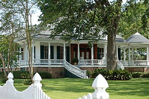
Ardoyne Plantation House
Historic house in Louisiana, United States
Distance: Approx. 5871 meters
Latitude and longitude: 29.64916667,-90.81944444
Ardoyne Plantation House is located on Highway 311 in Schriever, Louisiana, just northwest of Houma, Louisiana. It was built 1894 and added to the National Register of Historic Places on November 1, 1982.

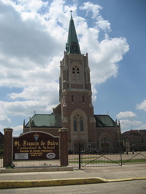
Cathedral of St. Francis de Sales (Houma, Louisiana)
Church in Louisiana, United States
Distance: Approx. 5943 meters
Latitude and longitude: 29.59466,-90.72277
The Cathedral of St. Francis de Sales is a Catholic cathedral located in Houma, Louisiana, United States. Along with St.
Southdown Plantation
Historic house in Louisiana, United States
Distance: Approx. 4575 meters
Latitude and longitude: 29.58875,-90.74027778
Southdown Plantation is a historic Southern plantation in Terrebonne Parish, Louisiana.
Polmer Store
United States historic place
Distance: Approx. 4931 meters
Latitude and longitude: 29.64222222,-90.81388889
The Polmer Store, built c. 1880, is a well-preserved example of the once-common plantation store, a type of company store used after slavery ended. The one-story frame structure in Terrebonne Parish, Louisiana, was added to the National Register of Historic Places in 1996.
Argyle (Houma, Louisiana)
United States historic place
Distance: Approx. 4902 meters
Latitude and longitude: 29.57277778,-90.75111111
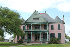
Argyle is a historic house on a former sugarcane plantation in Houma, Louisiana. It was built circa 1906 for Phelin Bonvillain, a sugar planter. It belongs to the Ingram family since 1947.

Clifford Percival Smith House
United States historic place
Distance: Approx. 6206 meters
Latitude and longitude: 29.59972222,-90.71888889
The Clifford Percival Smith House, also known as the Walker House, is a historic house in Houma, Louisiana, U.S.. It was built circa 1905 for Clifford Percival Smith and his wife, Clara. It belonged to the Smith family until 1986.
Orange Grove Plantation House (Terrebonne Parish, Louisiana)
United States historic place
Distance: Approx. 4457 meters
Latitude and longitude: 29.58861111,-90.82305556
The Orange Grove Plantation House is a historic house on a former plantation in Terrebonne Parish, about eight miles away from Houma, Louisiana. It was built in 1850 for John C. Beatty, a sugar planter who owned slaves. The plantation spanned 2,470 acres of land when it was sold at auction shortly after Beatty's death in 1857.
Weather in this IP's area
overcast clouds
16 Celsius
16 Celsius
14 Celsius
16 Celsius
1021 hPa
88 %
1021 hPa
1021 hPa
10000 meters
100 %


