204.116.233.129 - IP Lookup: Free IP Address Lookup, Postal Code Lookup, IP Location Lookup, IP ASN, Public IP
Country:
Region:
City:
Location:
Time Zone:
Postal Code:
ISP:
ASN:
language:
User-Agent:
Proxy IP:
Blacklist:
IP information under different IP Channel
ip-api
Country
Region
City
ASN
Time Zone
ISP
Blacklist
Proxy
Latitude
Longitude
Postal
Route
db-ip
Country
Region
City
ASN
Time Zone
ISP
Blacklist
Proxy
Latitude
Longitude
Postal
Route
IPinfo
Country
Region
City
ASN
Time Zone
ISP
Blacklist
Proxy
Latitude
Longitude
Postal
Route
IP2Location
204.116.233.129Country
Region
south carolina
City
north augusta
Time Zone
America/New_York
ISP
Language
User-Agent
Latitude
Longitude
Postal
ipdata
Country
Region
City
ASN
Time Zone
ISP
Blacklist
Proxy
Latitude
Longitude
Postal
Route
Popular places and events near this IP address

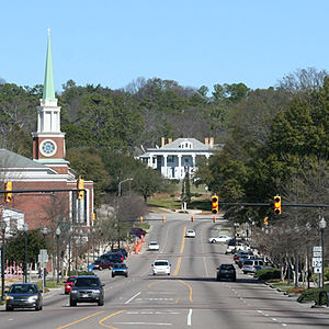
North Augusta, South Carolina
City in South Carolina, United States
Distance: Approx. 1271 meters
Latitude and longitude: 33.51305556,-81.96277778
North Augusta is a city in Aiken and Edgefield counties in the U.S. state of South Carolina, on the north bank of the Savannah River. It lies directly across the river, and state border, from Augusta, Georgia. The population was 24,379 at the 2020 census, making it the 21st-most populous city in South Carolina.

Hamburg, South Carolina
Ghost town in South Carolina, US
Distance: Approx. 2488 meters
Latitude and longitude: 33.48333333,-81.95
Hamburg is a ghost town in Aiken County, South Carolina, United States. It was once a thriving upriver market located across the Savannah River from Augusta, Georgia in the Edgefield District. It was founded by Henry Shultz in 1821 who named it after his home town in Germany of the same name.

Hamburg massacre
US incident of racial violence
Distance: Approx. 2707 meters
Latitude and longitude: 33.481,-81.95
The Hamburg massacre (or Red Shirt massacre or Hamburg riot) was a riot in the United States town of Hamburg, South Carolina, in July 1876, leading up to the last election season of the Reconstruction era. It was the first of a series of civil disturbances planned and carried out by white Democrats in the majority-black Republican Edgefield District, with the goal of suppressing black Americans' civil rights and voting rights and disrupting Republican meetings, through actual and threatened violence. Beginning with a dispute over free passage on a public road, the massacre was rooted in racial hatred and political motives.

Rosemary Hall (North Augusta, South Carolina)
Historic house in South Carolina, United States
Distance: Approx. 706 meters
Latitude and longitude: 33.49694444,-81.97
Rosemary Hall is a Greek Revival house in North Augusta, South Carolina that was built in 1900. It was listed on the National Register of Historic Places in 1978. Today, it serves as a boutique bed-and-breakfast.
Springfield Baptist Church (Augusta, Georgia)
Historic church in Georgia, United States
Distance: Approx. 2652 meters
Latitude and longitude: 33.47861111,-81.97166667
Springfield Baptist Church is a Baptist church in Augusta, Georgia was built in 1801 and is a significant historical building for its architecture, religious history, and African American heritage. It is affiliated with the American Baptist Churches USA. It was built in the architectural style of a New England meetinghouse, which is rare in Georgia. It is the oldest church building extant in Augusta and is claimed to be one of the oldest Black congregations in the U.S. The 1801, Springfield Baptist Church was listed on the National Register of Historic Places listings in Richmond County, Georgia in 1982, and the boundary of the National Register of Historic Places-listed site was increased in 1990.

Curtis Baptist School
Private Christian high school in Augusta, Georgia, United States
Distance: Approx. 2689 meters
Latitude and longitude: 33.479563,-81.976418
Curtis Baptist School (CBS) is a private 1-A Christian high school located in Augusta, Georgia, United States. It is a private school that has more than 300 students in the elementary, middle, and high school combined.

Lookaway Hall
Historic house in South Carolina, United States
Distance: Approx. 478 meters
Latitude and longitude: 33.49888889,-81.96888889
Lookaway Hall, built from 1895 to 1898, is a North Augusta, South Carolina landmark. A number of architectural details are significant, for the home was built in the Beaux Arts and Revival styles, made popular after the World's Columbian Exposition. This accessible landmark, near the historic Georgia Avenue-Butler Avenue Historic District, was listed in the National Register of Historic Places on August 13, 1992.
Britton Mims Place
Historic house in South Carolina, United States
Distance: Approx. 2870 meters
Latitude and longitude: 33.52416667,-81.94972222
The Britton Mims Place, located in North Augusta, South Carolina, exemplifies the Greek Revival style typical of secondary country residences during the antebellum period. Built around 1830, it is historically significant due to a number of architectural features, including its gabled roof, full width front verandah with hipped roof, and a number of outbuildings, including a (former) kitchen, wooden dog house, and a rectangular fowl house. This well-secluded home is not visible from the public highway.

B.C. Wall House
Historic house in South Carolina, United States
Distance: Approx. 611 meters
Latitude and longitude: 33.50222222,-81.97166667
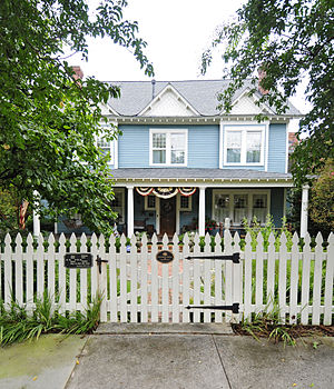
The B.C. Wall House, also known as the “Sesame Lodge,” is located at North Augusta, Aiken County, South Carolina. It was constructed in 1902 by Budd Clay Wall (the mayor of North Augusta at the time) to serve as an overflow guest home from the Hampton Terrace Hotel. The home holds additional significance in that it was designed by a female architect, Wall's daughter, Martha Louise Wall Andrews.
Augusta Cotton Exchange Building
United States historic place
Distance: Approx. 2829 meters
Latitude and longitude: 33.47638889,-81.96472222
Augusta Cotton Exchange Building is a historic building in Augusta, Georgia. It was designed by Enoch William Brown and built in the mid-1880s during a cotton boom. The structure includes ornate details and ironwork and is considered High Victorian architecture.

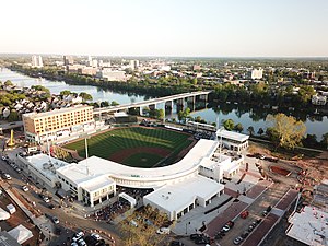
SRP Park
Baseball park in North Augusta, South Carolina
Distance: Approx. 2154 meters
Latitude and longitude: 33.48388889,-81.97388889
SRP Park is a baseball park in North Augusta, South Carolina, which is part of the Augusta, Georgia metropolitan area. It is the home of the Augusta GreenJackets, a Minor League Baseball team playing in the Single-A Carolina League. It opened on April 12, 2018, and can seat 4,782 people.
Meriwether Monument
Distance: Approx. 613 meters
Latitude and longitude: 33.49759,-81.96936
The Meriwether Monument is a pillar erected in 1916 at John C. Calhoun Park in North Augusta, South Carolina, to commemorate Thomas McKie Meriwether (December 4, 1852 – July 8, 1876), the only white man killed in the Hamburg massacre when white supremacist militias attacked African Americans in coordinated political violence, seeking to restore the Democratic Party to power and disenfranchise African American voters. The massacre occurred in 1876 and was part of a violent political campaign at the end of the Reconstruction era. The monument was erected 40 years later during the Jim Crow era.
Weather in this IP's area
clear sky
5 Celsius
2 Celsius
3 Celsius
6 Celsius
1020 hPa
56 %
1020 hPa
1008 hPa
10000 meters
4.12 m/s
250 degree

