203.99.78.199 - IP Lookup: Free IP Address Lookup, Postal Code Lookup, IP Location Lookup, IP ASN, Public IP
Country:
Region:
City:
Location:
Time Zone:
Postal Code:
IP information under different IP Channel
ip-api
Country
Region
City
ASN
Time Zone
ISP
Blacklist
Proxy
Latitude
Longitude
Postal
Route
Luminati
Country
ASN
Time Zone
Asia/Tokyo
ISP
OCC Co., Ltd.
Latitude
Longitude
Postal
IPinfo
Country
Region
City
ASN
Time Zone
ISP
Blacklist
Proxy
Latitude
Longitude
Postal
Route
IP2Location
203.99.78.199Country
Region
okinawa
City
naha
Time Zone
Asia/Tokyo
ISP
Language
User-Agent
Latitude
Longitude
Postal
db-ip
Country
Region
City
ASN
Time Zone
ISP
Blacklist
Proxy
Latitude
Longitude
Postal
Route
ipdata
Country
Region
City
ASN
Time Zone
ISP
Blacklist
Proxy
Latitude
Longitude
Postal
Route
Popular places and events near this IP address

Okinawa Prefecture Government Building
Building in Naha City, Okinawa, Japan
Distance: Approx. 222 meters
Latitude and longitude: 26.2124,127.681
The Okinawa Prefecture Government Building (Japanese: 沖縄県庁舎, Hepburn: Okinawakenchōsha) is one of the tallest buildings in Naha City, Okinawa, Japan, and is the center for Japanese governmental functions stretching across Okinawa Prefecture. There are 14 floors above ground and two below including a civic hall and government information center. The top floor houses an observation deck where a panoramic view of Naha City can be seen.

Naha
Capital city of Okinawa Prefecture, Japan
Distance: Approx. 39 meters
Latitude and longitude: 26.21222222,127.67916667
Naha (那覇市, Naha-shi, Japanese: [naꜜha], Okinawan: Nāfa or Nafa) is the capital city of Okinawa Prefecture, the southernmost prefecture of Japan. As of 1 June 2019, the city has an estimated population of 317,405 and a population density of 7,939 people per km2 (20,562 persons per sq. mi.).
Kumemura
Location of Ryukyu Kingdom bureaucracy
Distance: Approx. 664 meters
Latitude and longitude: 26.21744,127.675831
Kumemura (久米村, Okinawan: Kuninda; Middle Chinese: Kjú-méi ts'won) was an Okinawan community of scholars, bureaucrats, and diplomats in the port city of Naha near the royal capital of Shuri, which was a center of culture and learning during the time of the Ryukyu Kingdom. The people of Kumemura, traditionally believed to all be descendants of the Chinese immigrants who first settled there in 1392, came to form an important and aristocratic class of scholar-bureaucrats, the yukatchu, who dominated the royal bureaucracy, and served as government officials at home, and as diplomats in relations with China, Japan, and others. The community's special function came to an end in 1879, with Okinawa's formal annexation to Japan, and it has since been geographically absorbed into the prefectural capital of Naha; the area is now known simply as Kume.
Roman Catholic Diocese of Naha
Roman Catholic diocese in Japan
Distance: Approx. 39 meters
Latitude and longitude: 26.21222222,127.67916667
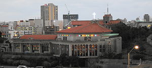
The Diocese of Naha (Latin: Dioecesis Nahana, Japanese: カトリック那覇教区) is a Latin Church diocese of the Catholic Church in the ecclesiastical province of the Metropolitan Nagasaki 長崎, in southern Japan. Its cathedral episcopal see is the Cathedral of the Immaculate Heart of Mary (Kainan Church), located in the city of Naha (on and administrative capital of Okinawa).
Fukushūen
Distance: Approx. 713 meters
Latitude and longitude: 26.21797,127.675943
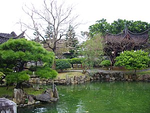
Fukushūen (福州園, lit. "Fuzhou Garden" or "Foochow Garden") is a traditional Chinese garden in the Kume area of Naha, Okinawa. The garden was constructed in 1992, in celebration of the 10th anniversary of the establishment of the sister city relationship between Naha and Fuzhou in China.

Shiseibyō
Distance: Approx. 1043 meters
Latitude and longitude: 26.21916667,127.67194444
The Shiseibyō (至聖廟) is a Confucian temple in the Wakasa district of Naha, Okinawa. It served for centuries as a major center of Chinese learning for the Ryūkyū Kingdom, and contains within its precincts the Meirindō, first public school in Okinawa.

Gusuku Sites and Related Properties of the Kingdom of Ryukyu
UNESCO World Heritage Site in Okinawa Prefecture, Japan
Distance: Approx. 556 meters
Latitude and longitude: 26.20861111,127.68277778
The Gusuku Sites and Related Properties of the Kingdom of Ryukyu (琉球王国のグスク及び関連遺産群, Ryūkyū ōkoku no gusuku oyobi kanren'isangun) is an UNESCO World Heritage Site which consists of nine sites all located in the Okinawa Prefecture, Japan. The heritage sites include two utaki (or sacred sites, one a gate and the other a grove), the Tamaudun mausoleum, one garden, and five gusuku castles sites, four of which are ruins and one of which is a reconstruction. The sites were inscribed based on the criteria that they were a fine representation of the Ryūkyū Kingdom's culture, whose unique blend of Japanese and Chinese influence made it a crucial economic and cultural junction between several neighboring states.
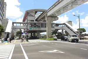
Tsubogawa Station
Monorail station in Naha, Okinawa, Japan
Distance: Approx. 706 meters
Latitude and longitude: 26.2058,127.678
Tsubogawa Station (壺川駅, Tsubogawa-eki) is a railway station on the Okinawa Urban Monorail (Yui Rail) located in Naha, Okinawa, Japan.

Asahibashi Station
Monorail station in Naha, Okinawa Prefecture, Japan
Distance: Approx. 380 meters
Latitude and longitude: 26.2119,127.675
Asahibashi Station (旭橋駅, Asahibashi-eki) is one of the railway station on the Okinawa Urban Monorail (Yui Rail) located in Naha, Okinawa Prefecture, Japan.
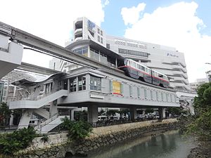
Prefectural Office Station
Monorail station in Naha, Okinawa Prefecture, Japan
Distance: Approx. 257 meters
Latitude and longitude: 26.2144,127.679
Prefectural Office Station (県庁前駅, Kenchō-mae-eki) is a railway station on the Okinawa Urban Monorail (Yui Rail) in Naha, Okinawa Prefecture, Japan.
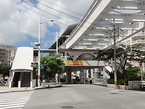
Miebashi Station
Monorail station in Naha, Okinawa Prefecture, Japan
Distance: Approx. 946 meters
Latitude and longitude: 26.2192,127.684
Miebashi Station (美栄橋駅, Miebashi-eki) is one of the railway station on the Okinawa Urban Monorail (Yui Rail) located in Naha, Okinawa Prefecture, Japan.

Naha City Museum of History
Building in Okinawa Prefecture, Japan
Distance: Approx. 193 meters
Latitude and longitude: 26.21378075,127.67925408
Naha City Museum of History (那覇市歴史博物館, Naha-shi Rekishi Hakubutsukan) opened in Naha, Okinawa Prefecture, Japan, in 2006. The collection includes the National Treasure Materials relating to the Shō Family of Ryūkyū Kings. The digital museum was launched in 2014.
Weather in this IP's area
broken clouds
15 Celsius
14 Celsius
13 Celsius
15 Celsius
1026 hPa
49 %
1026 hPa
1024 hPa
10000 meters
7.72 m/s
340 degree
75 %
