203.99.77.145 - IP Lookup: Free IP Address Lookup, Postal Code Lookup, IP Location Lookup, IP ASN, Public IP
Country:
Region:
City:
Location:
Time Zone:
Postal Code:
IP information under different IP Channel
ip-api
Country
Region
City
ASN
Time Zone
ISP
Blacklist
Proxy
Latitude
Longitude
Postal
Route
Luminati
Country
ASN
Time Zone
Asia/Tokyo
ISP
OCC Co., Ltd.
Latitude
Longitude
Postal
IPinfo
Country
Region
City
ASN
Time Zone
ISP
Blacklist
Proxy
Latitude
Longitude
Postal
Route
IP2Location
203.99.77.145Country
Region
okinawa
City
ginowan
Time Zone
Asia/Tokyo
ISP
Language
User-Agent
Latitude
Longitude
Postal
db-ip
Country
Region
City
ASN
Time Zone
ISP
Blacklist
Proxy
Latitude
Longitude
Postal
Route
ipdata
Country
Region
City
ASN
Time Zone
ISP
Blacklist
Proxy
Latitude
Longitude
Postal
Route
Popular places and events near this IP address

Ginowan, Okinawa
City in Okinawa, Japan
Distance: Approx. 5 meters
Latitude and longitude: 26.28166667,127.77833333
Ginowan (宜野湾市, Ginowan-shi) (Okinawan: ジノーン, romanized: Jinōn) is a city located in Okinawa Prefecture, Japan. As of 2024, the city has an estimated population of 100,319, with 47,490 households and a population density of 5,142 persons per km2. The total area is 19.51 km2.

Nakagami District, Okinawa
District in Okinawa Prefecture, Japan
Distance: Approx. 3059 meters
Latitude and longitude: 26.30916667,127.77722222
Nakagami (中頭郡, Nakagami-gun, Okinawan: Nakajan) is a district located in Okinawa Prefecture, Japan. As of 2003, the district has an estimated population of 169,332 and the density of 1,216.03 persons per km2. The total area is 139.25 km2.

Kitanakagusuku, Okinawa
Village in Kyushu, Japan
Distance: Approx. 2615 meters
Latitude and longitude: 26.30111111,127.79305556
Kitanakagusuku (北中城村, Kitanakagusuku-son, Okinawan: キタナカグシク, romanized: Kitanakagushiku) is a village located in Nakagami District, Okinawa Prefecture, Japan. As of 1 October 2020, the village has an estimated population of 17,969 and the density of 1,600 persons per km². The total area is 11.53 km².

Nakagusuku, Okinawa
Village in Ryukyu, Japan
Distance: Approx. 2027 meters
Latitude and longitude: 26.26777778,127.79138889
Nakagusuku (中城村, Nakagusuku-son, Okinawan: Nakagushiku) is a village located in Nakagami District, Okinawa Prefecture, Japan. As of 1 August 2024, the village has an estimated population of 22,647 and a density of 1,465 persons per km2. The total area is 15.53 km2.

Marine Corps Air Station Futenma
Airport
Distance: Approx. 3252 meters
Latitude and longitude: 26.27083333,127.74805556
Marine Corps Air Station Futenma or MCAS Futenma (Japanese: 海兵隊普天間航空基地, Hepburn: Kaiheitai Futenma Kōkū Kichi)A (ICAO: ROTM) is a United States Marine Corps base located in Ginowan, Okinawa, Japan, 5 NM (9.3 km; 5.8 mi) northeastB of Naha, on the island of Okinawa. It is home to approximately 3,000 Marines of the 1st Marine Aircraft Wing and other units, and has been a U.S. military airbase since the defeat of the Japanese Imperial Army in the Battle of Okinawa in 1945. Marine Corps pilots and aircrew are assigned to the base for training and providing air support to other land and sea-based Marines in Okinawa and throughout the Asia-Pacific region.

Camp Foster
U.S. Marine Corps facility in Okinawa, Japan
Distance: Approx. 2196 meters
Latitude and longitude: 26.30138889,127.77972222
Camp Foster, formerly known as Camp Zukeran (Japanese: キャンプ・フォスター), is a United States Marine Corps camp located in Ginowan City with portions overlapping into Okinawa City, Chatan town and Kitanakagusuku village in the Japanese prefecture of Okinawa Island. It is part of the Marine Corps Base Camp Smedley D. Butler complex.

Marine Corps Base Camp Smedley D. Butler
United States Marine Corps base in the Japanese prefecture of Okinawa
Distance: Approx. 1805 meters
Latitude and longitude: 26.29736,127.782983
Marine Corps Base Camp Smedley D. Butler (or simply Butler Marine Base) is a United States Marine Corps base located in the Japanese prefecture of Okinawa. It was named after Marine Corps Major General and twice Medal of Honor recipient Smedley D. Butler.

Kubasaki High School
Dodea private school in Okinawa, Japan
Distance: Approx. 2653 meters
Latitude and longitude: 26.305419,127.780867
Kubasaki High School (クバサキ高校, Kubasaki Kōkō) is a United States Department of Defense Dependents School on Okinawa, in Kitanakagusuku. Kubasaki is the second oldest operating high school in the Department of Defense Dependents Schools system. Only W.T. Sampson High School (1931) at Guantanamo Bay Naval Base in Cuba is older.
Okinawa International University
Distance: Approx. 3303 meters
Latitude and longitude: 26.26194444,127.75361111
Okinawa International University (沖縄国際大学, Okinawa kokusai daigaku, often abbreviated as (沖国大 Okikokudai), is a private university in Ginowan, Okinawa, Japan. The predecessor of the school was founded in 1959, and it was chartered as a university in 1972. The current President is Eiken Maetsu.
1996 Padilla car crash
Fatal crash in Okinawa caused by a speeding U.S. serviceman
Distance: Approx. 2319 meters
Latitude and longitude: 26.2956,127.761
The 1996 Padilla car crash occurred in Okinawa, Japan, on 7 January 1996. Lori Padilla, a member of the United States Marine Corps in Okinawa, was speeding in a car which swerved off the road, killing Rojita Kinjo and her young daughters Mitsuko and Mariko. The crash sparked outrage in Okinawa and strengthened opposition to the U.S. military presence in Japan, which was already facing scrutiny over the 1995 Okinawan rape incident that occurred only a few months earlier.

Nakagusuku Castle
UNESCO World Heritage Site
Distance: Approx. 2317 meters
Latitude and longitude: 26.28388889,127.80138889
Nakagusuku Castle (中城城, Nakagusuku jō, Okinawan: Nakagushiku) is a gusuku in the village of Kitanakagusuku, Okinawa, Japan. It is one of a number of castles built on the island of Okinawa by the Ryukyu Kingdom now in ruins.

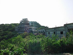
Nakagusuku Hotel ruins
Abandoned building in Kitanakagusuku, Okinawa, Japan
Distance: Approx. 1981 meters
Latitude and longitude: 26.2829,127.7981
The Nakagusuku Hotel site (中城ホテル跡, Nakagusuku Hoteru ato), also known as the Royal Hotel or Takahara or Kogen Hotel (高原ホテル, Takahara/Kōgen Hoteru), is an abandoned, unfinished hotel in Kitanakagusuku, Okinawa. It sits no more than 50 meters from the walls of Nakagusuku Castle. As of May 2020, the hotel has been fully demolished.
Weather in this IP's area
overcast clouds
17 Celsius
17 Celsius
16 Celsius
17 Celsius
1023 hPa
87 %
1023 hPa
1011 hPa
10000 meters
7.72 m/s
20 degree
100 %