203.99.111.59 - IP Lookup: Free IP Address Lookup, Postal Code Lookup, IP Location Lookup, IP ASN, Public IP
Country:
Region:
City:
Location:
Time Zone:
Postal Code:
ISP:
ASN:
language:
User-Agent:
Proxy IP:
Blacklist:
IP information under different IP Channel
ip-api
Country
Region
City
ASN
Time Zone
ISP
Blacklist
Proxy
Latitude
Longitude
Postal
Route
db-ip
Country
Region
City
ASN
Time Zone
ISP
Blacklist
Proxy
Latitude
Longitude
Postal
Route
IPinfo
Country
Region
City
ASN
Time Zone
ISP
Blacklist
Proxy
Latitude
Longitude
Postal
Route
IP2Location
203.99.111.59Country
Region
papua barat
City
manokwari
Time Zone
Asia/Jayapura
ISP
Language
User-Agent
Latitude
Longitude
Postal
ipdata
Country
Region
City
ASN
Time Zone
ISP
Blacklist
Proxy
Latitude
Longitude
Postal
Route
Popular places and events near this IP address

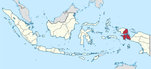
West Papua (province)
Province in Indonesia
Distance: Approx. 5 meters
Latitude and longitude: -0.86666667,134.08333333
West Papua (Indonesian: Papua Barat), formerly Irian Jaya Barat (West Irian), is an Indonesian province located in Indonesia Papua. It covers most of the two western peninsulas of the island of New Guinea: the eastern half of the Bird's Head Peninsula (or Doberai Peninsula) and the whole of the Bomberai Peninsula, along with nearby smaller islands. The province is bordered to the north by the Pacific Ocean, to the west by Southwest Papua Province, the Halmahera Sea and the Ceram Sea, to the south by the Banda Sea, and to the east by the province of Central Papua and the Cenderawasih Bay.

Manokwari
City and capital of West Papua, Indonesia
Distance: Approx. 5 meters
Latitude and longitude: -0.86666667,134.08333333
Manokwari is a coastal town and the capital of the Indonesian province of West Papua. It is one of only seven provincial capitals of Indonesia without a city status. It is also the administrative seat of Manokwari Regency.
Sanggeng Stadium
Multi-purpose stadium in Indonesia
Distance: Approx. 2432 meters
Latitude and longitude: -0.867538,134.061468
Sanggeng Stadium is a multi-purpose stadium in Manokwari, Indonesia. It is currently used mostly for football matches and is used as the home venue for Perseman Manokwari. The stadium holds 10,000 people.

Rendani Airport
Airport in Manokwari, West Papua, Indonesia
Distance: Approx. 4707 meters
Latitude and longitude: -0.89166667,134.04916667
Rendani Airport (IATA: MKW, ICAO: WAUU; formerly WASR), in Manokwari, West Papua, Indonesia, is one of the largest and busiest airports in West Papua. The airport has one runway, designated 17/35, with an asphalt surface measuring 2000 by 45 meters (6562 ft x148 ft). A new terminal, cargo building and larger apron were finished in 2013.

University of Papua
Higher education institution in Manokwari, Indonesia
Distance: Approx. 3895 meters
Latitude and longitude: -0.8343,134.0701
The University of Papua (Indonesian: Universitas Papua) is a public university in the province of West Papua, Indonesia. It has three campuses: Manokwari, Sorong, and Raja Ampat. The university teaches Economics, Forestry, Agriculture, and Earth Sciences.

Merpati Nusantara Airlines Flight 836
2010 runway excursion in Indonesia
Distance: Approx. 4255 meters
Latitude and longitude: -0.88083333,134.04777778
Merpati Nusantara Airlines Flight 836 was a scheduled domestic flight between Sorong and Manokwari, Indonesia. On 13 April 2010, the flight, operated by Boeing 737-300 (registered as PK-MDE), overran the runway on landing. The aircraft broke into three pieces.

Manokwari Regency
Regency in West Papua, Indonesia
Distance: Approx. 2189 meters
Latitude and longitude: -0.8629,134.064
Manokwari Regency is a regency in West Papua, Indonesia. Following the splitting away of twenty of its former districts in 2013, it now covers an area of 2,762.89 km2 and had a population of 192,663 at the 2020 Census; the official estimate as at mid 2023 was 201,821 (comprising 104,585 males and 97,236 females). The administrative centre (regency seat) is presently at the town of Manokwari, which is also the capital of the province.
Amban Beach
Distance: Approx. 5728 meters
Latitude and longitude: -0.815389,134.079389
Pantai Amban is a beach on the northeast head of the Bird's Head Peninsula, West Papua, Indonesia, 3 kilometres (1.9 mi) north of Amban village and 7 kilometres (4.3 mi) north of Manokwari. Surrounded by tropical forest and swampland, the black sand beach is a notable surfing spot.

Mansinam Island
Island in Indonesia
Distance: Approx. 4413 meters
Latitude and longitude: -0.90182639,134.10167722
Mansinam Island (Pulau Mansinam) is an Island in West Papua, Indonesia popular for religious tourism, especially for Christians due to its historical significance in the evangelisation of Papua. It is located 6 km from Manokwari city. To reach this island it is needed about 10–15 minutes by speed boat.
Weather in this IP's area
few clouds
27 Celsius
29 Celsius
27 Celsius
27 Celsius
1009 hPa
80 %
1009 hPa
1006 hPa
10000 meters
2.39 m/s
3.32 m/s
284 degree
13 %