Country:
Region:
City:
Latitude and Longitude:
Time Zone:
Postal Code:
IP information under different IP Channel
ip-api
Country
Region
City
ASN
Time Zone
ISP
Blacklist
Proxy
Latitude
Longitude
Postal
Route
Luminati
Country
ASN
Time Zone
Asia/Kuching
ISP
Malaysian Research & Education Network
Latitude
Longitude
Postal
IPinfo
Country
Region
City
ASN
Time Zone
ISP
Blacklist
Proxy
Latitude
Longitude
Postal
Route
db-ip
Country
Region
City
ASN
Time Zone
ISP
Blacklist
Proxy
Latitude
Longitude
Postal
Route
ipdata
Country
Region
City
ASN
Time Zone
ISP
Blacklist
Proxy
Latitude
Longitude
Postal
Route
Popular places and events near this IP address

Cyberjaya
Town in Sepang, Selangor, Malaysia
Distance: Approx. 147 meters
Latitude and longitude: 2.9225,101.655
Cyberjaya (a portmanteau of cyber and Putrajaya) is a city with a science park as its core that forms a key part of the Kuala Lumpur in Malaysia. It is located in Sepang District, Selangor. Cyberjaya is adjacent to and developed along with Putrajaya, Malaysia's government seat.

Seri Saujana Bridge
Bridge in Putrajaya, Malaysia
Distance: Approx. 2522 meters
Latitude and longitude: 2.9135,101.67641667
The Seri Saujana Bridge is a main bridge in the planned city Putrajaya, the new (2001) Malaysian federal territory and administrative centre. The bridge's design is a unique combination of a symmetric cable-stayed structure and a through-arch bridge; the through-arch bridge portion is reminiscent of a slender version of the Sydney Harbour Bridge in Sydney, New South Wales, Australia. The Seri Saujana bridge, also called Bridge No 8, crosses Putrajaya Lake, an artificial lake made to provide natural cooling, and connects the Core Island (Precinct 4) to the Precinct 7 on Lebuh Sentosa highway.

Monorail Suspension Bridge
Bridge in Putrajaya Monorail
Distance: Approx. 2689 meters
Latitude and longitude: 2.91616667,101.67908333
Monorail Suspension Bridge is one of the many bridges in Putrajaya, Malaysia. It was built to link several important landmarks in the Putrajaya area like the Putrajaya Convention Centre, Putra Mosque and the Government Administrative Complex in Parcel E. The bridge's main span has a length of approximately 240 metres and width of 10 metres. It is owned by Putrajaya Holdings Sdn.

Limkokwing University of Creative Technology
Private university in Malaysia
Distance: Approx. 1987 meters
Latitude and longitude: 2.94,101.6625
Limkokwing University of Creative Technology (also called Limkokwing and LUCT) is a private university that has a presence across Africa, Europe, and Asia. With its main campus in Malaysia, the university has over 30,000 students from more than 150 countries. The university offers a wide range of programs at the undergraduate and postgraduate levels in various fields of study, including design, multimedia, communication, business, and technology.

Putrajaya Sentral
Bus hub and train station in Putrajaya, Malaysia
Distance: Approx. 1893 meters
Latitude and longitude: 2.93152778,101.67094444
Putrajaya Sentral is a bus hub and a train station in Presint 7, Putrajaya, Malaysia. It is served by the MRT Putrajaya Line, as well as the ERL KLIA Transit Line under the name Putrajaya & Cyberjaya. Putrajaya Sentral also comprises other multimodal transport services apart from the ERL & MRT stations, which includes the unfinished Putrajaya Monorail station (abandoned as of now), a taxi centre, and a bus hub (currently utilised by Rapid KL and Nadi Putra buses) that has city buses serving Putrajaya, express buses and scheduled intercity buses.

International Multilateral Partnership Against Cyber Threats
United Nations-backed cybersecurity alliance
Distance: Approx. 723 meters
Latitude and longitude: 2.9193135,101.66107812
The International Multilateral Partnership Against Cyber Threats (IMPACT) is the first United Nations-backed cybersecurity alliance. Since 2011, IMPACT serves as a key partner of the United Nations (UN) specialized agency for ICTs – the International Telecommunication Union (ITU). Being the first comprehensive public-private partnership against cyber threats, IMPACT serves as a politically neutral global platform that brings together governments of the world, industry, and academia to enhance the global community's capabilities in dealing with cyber threats.

Tuanku Mizan Zainal Abidin Mosque
Mosque in Putrajaya, Malaysia
Distance: Approx. 2807 meters
Latitude and longitude: 2.91930556,101.68091667
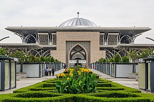
The Tuanku Mizan Zainal Abidin Mosque (Malay: Masjid Tuanku Mizan Zainal Abidin; Jawi: مسجد توانكو ميزان زين العابدين) or the Iron Mosque (Malay: Masjid Besi) is the second principal mosque in Putrajaya, Malaysia after Putra Mosque. It is located in Putrajaya's Precinct 3, opposite the Palace of Justice and next to Islamic Complex Putrajaya, a religious authority headquarters. Construction began since April 2004 and was fully completed in August 2009.
Kirkby International College
College in Sepang, Selangor, Malaysia
Distance: Approx. 1468 meters
Latitude and longitude: 2.9105,101.6531411
Kirkby International College (KIC) is a further education college based at Pesiaran APEC, Cyberjaya, Selangor, Malaysia. The institution was officially launched by the Malaysian Deputy Prime Minister Tan Sri Muhyiddin Yassin in January 2014.
Raja Haji Fisabilillah Mosque
Principal mosque in Cyberjaya, Sepang, Selangor, Malaysia
Distance: Approx. 1346 meters
Latitude and longitude: 2.93244444,101.648
The Raja Haji Fisabilillah Mosque or Cyberjaya Mosque is a principal mosque in Cyberjaya, Sepang, Selangor, Malaysia. This modern futuristic mosque was named after Raja Haji Fisabilillah ibni Daeng Chelak, a Bugis warrior from Penyengat Island, Indonesia. He was also the Yang Dipertuan Muda (Viceroy) of the Johor-Riau Sultanate from 1777 to 1784.
University of Cyberjaya
Private university in Malaysia
Distance: Approx. 724 meters
Latitude and longitude: 2.92983333,101.65530556
University of Cyberjaya (UoC) is a private university established in 2005, located in Cyberjaya, Sepang District, Selangor, Malaysia, with strength in the medical sciences and alternative medicine.

Cyberjaya City Centre MRT station
Metro station in Selangor, Malaysia
Distance: Approx. 2004 meters
Latitude and longitude: 2.93844444,101.66586111
The Cyberjaya City Centre MRT station, or Cyberjaya City Centre–Limkokwing station due to sponsorship reasons, is a mass rapid transit (MRT) station. It is one of two train stations that serve the town of Cyberjaya, the other being Cyberjaya Utara. It is one of the stations as part of the Klang Valley Mass Rapid Transit (KVMRT) project on the MRT Putrajaya Line.
Putrajaya Hospital
Hospital in Putrajaya, Malaysia
Distance: Approx. 2122 meters
Latitude and longitude: 2.9291,101.6742
Putrajaya Hospital is a Malaysian government-owned rural general hospital in the administrative region of Putrajaya. Originally founded in 1998, this hospital has 369 beds. As a hospital located in the Multimedia Super Corridor, it has managed and maintained the hospital using the Full Hospital Information System ("Total Hospital Information System - T.H.I.S.").
Weather in this IP's area
light rain
28 Celsius
34 Celsius
27 Celsius
29 Celsius
1010 hPa
99 %
1010 hPa
1009 hPa
10000 meters
0.51 m/s
0.75 m/s
66 degree
70 %
06:58:45
18:57:49


