203.76.114.78 - IP Lookup: Free IP Address Lookup, Postal Code Lookup, IP Location Lookup, IP ASN, Public IP
Country:
Region:
City:
Location:
Time Zone:
Postal Code:
IP information under different IP Channel
ip-api
Country
Region
City
ASN
Time Zone
ISP
Blacklist
Proxy
Latitude
Longitude
Postal
Route
Luminati
Country
Region
c
City
dhaka
ASN
Time Zone
Asia/Dhaka
ISP
Link3 Technologies Ltd.
Latitude
Longitude
Postal
IPinfo
Country
Region
City
ASN
Time Zone
ISP
Blacklist
Proxy
Latitude
Longitude
Postal
Route
IP2Location
203.76.114.78Country
Region
rajshahi
City
sirajganj
Time Zone
Asia/Dhaka
ISP
Language
User-Agent
Latitude
Longitude
Postal
db-ip
Country
Region
City
ASN
Time Zone
ISP
Blacklist
Proxy
Latitude
Longitude
Postal
Route
ipdata
Country
Region
City
ASN
Time Zone
ISP
Blacklist
Proxy
Latitude
Longitude
Postal
Route
Popular places and events near this IP address

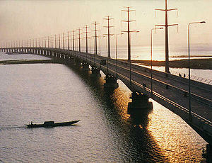
Bangabandhu Bridge
Bridge in Bangladesh
Distance: Approx. 8471 meters
Latitude and longitude: 24.39861111,89.77833333
Jamuna Multi-purpose Bridge (Bengali: যমুনা বহুমুখী সেতু, romanized: Jamuna Bahumukhee Setu), also known as Bangabandhu Bridge, is a bridge built over the river Jamuna in Bangladesh. The bridge was opened in June 1998. With a lenth of 4.8 kilometres, it is the second longest bridge of Bangladesh.

Sirajganj
City in Rajshahi, Bangladesh
Distance: Approx. 1626 meters
Latitude and longitude: 24.46,89.705
Sirajganj is a city in north-western Bangladesh on the right bank of the Jamuna River, located in Rajshahi Division. It is the administrative headquarters of Sirajganj District, and with a population of 188,528 is the 14th largest city in Bangladesh. It is about 110 kilometres (68 mi) north west of the capital, Dhaka.

Sirajganj Sadar Upazila
Upazila in Rajshahi, Bangladesh
Distance: Approx. 1930 meters
Latitude and longitude: 24.45833333,89.7
Sirajganj Sadar (Bengali: সিরাজগঞ্জ সদর) is an upazila, or sub-district of Sirajganj District, located in Rajshahi Division, Bangladesh.
Enayetpur
Town in Rajshahi, Bangladesh
Distance: Approx. 8471 meters
Latitude and longitude: 24.39861111,89.77833333
Enayetpur is a town in Sirajganj District, Rajshahi Division, Bangladesh. Enayetpur lies near the banks of the river Jamuna, about 137 kilometres (85 mi) northwest of Dhaka, near the Jamuna Bridge.
Sabuj Kanan High School
Secondary school in Bangladesh
Distance: Approx. 1830 meters
Latitude and longitude: 24.4629,89.7055
Sabuj Kanan High School & College (Bengali: সবুজ কানন উচ্চ বিদ্যালয়) is a secondary school in Sirajganj town, Sirajganj Sadar Upazila, Sirajganj District, Bangladesh.
Shaeed Samsuddin Stadium
Multi-sport stadium in Sirajganj, Bangladesh
Distance: Approx. 867 meters
Latitude and longitude: 24.45573889,89.71092222
Sirajganj Stadium is a multi-sport stadium located by the Medical Assistant Training School in Sirajganj, Bangladesh.
Randhunibari
Village in Bangladesh
Distance: Approx. 8480 meters
Latitude and longitude: 24.37388889,89.72027778
Randhunibari (Postal Code - 6742) is a village of Belkuchi Upazila, Sirajganj District, Bangladesh. The village is situated at alongside of the Jamuna, the longest river of the country. Generally, the people of this village handle their own business and the leading business is all about textile.
Shaheed M. Monsur Ali Medical College, Sirajganj
Government medical college in Sirajganj, Bangladesh
Distance: Approx. 4352 meters
Latitude and longitude: 24.448777,89.673778
Shaheed M. Monsur Ali Medical College, Sirajganj (SMMAMC) (Bengali: শহীদ এম. মনসুর আলী মেডিকেল কলেজ, সিরাজগঞ্জ) (শএমমআমেক) is a public medical school in Bangladesh, established in 2014. It is located at Sirajganj District.

Islamia Government College
Distance: Approx. 1331 meters
Latitude and longitude: 24.4613,89.7124
Islamia Government College (Bengali: ইসলামিয়া সরকারি কলেজ) is a government owned college in Sirajganj, Bangladesh. It is one of the first colleges in Bangladesh, established in 1921. The college is affiliated with National University.

Sirajganj-2
Constituency of Bangladesh's Jatiya Sangsad
Distance: Approx. 1692 meters
Latitude and longitude: 24.45,89.7
Sirajganj-2 is a constituency represented in the Jatiya Sangsad (National Parliament) of Bangladesh (Dissolved) By Interim Government Of Bangladesh | Due To (July Massacre) And flee Of Sheikh Hasina of the Awami League On August 5 2024.
Elliott Bridge, Sirajganj
Bridge in Sirajganj, Bangladesh
Distance: Approx. 1451 meters
Latitude and longitude: 24.46058333,89.70833333
Elliott Bridge (locally known as Boropool) is an old bridge over the Boral River in Sirajganj, north-western Bangladesh. The pillarless bridge is named after the Lieutenant Governor named Charles Alfred Elliott. It cost 45 thousand takas to make it.

Bangabandhu Railway Bridge
Bridge in Sirajganj, & Tangail Bangladesh
Distance: Approx. 7415 meters
Latitude and longitude: 24.4026,89.7681
The Jamuna Railway Bridge is an under-construction dual-gauge, double-track railway bridge on Jamuna River. This bridge connects Sirajganj with Tangail by railway network. After construction this bridge will be the longest solo railway bridge in Bangladesh.
Weather in this IP's area
scattered clouds
19 Celsius
19 Celsius
19 Celsius
19 Celsius
1017 hPa
73 %
1017 hPa
1015 hPa
10000 meters
2.17 m/s
2.3 m/s
56 degree
30 %