Country:
 Australia
Region:
City:
Latitude and Longitude:
Time Zone:
Postal Code:
IP information under different IP Channel
ip-api
Country
Region
City
ASN
Time Zone
ISP
Blacklist
Proxy
Latitude
Longitude
Postal
Route
IPinfo
Country
Region
City
ASN
Time Zone
ISP
Blacklist
Proxy
Latitude
Longitude
Postal
Route
MaxMind
Country
Region
City
ASN
Time Zone
ISP
Blacklist
Proxy
Latitude
Longitude
Postal
Route
Luminati
Country
AUASN
Time Zone
Australia/Sydney
ISP
URSYS PTY. LTD.
Latitude
Longitude
Postal
db-ip
Country
Region
City
ASN
Time Zone
ISP
Blacklist
Proxy
Latitude
Longitude
Postal
Route
ipdata
Country
Region
City
ASN
Time Zone
ISP
Blacklist
Proxy
Latitude
Longitude
Postal
Route
Popular places and events near this IP address

Leichhardt, New South Wales
Suburb of Sydney, New South Wales, Australia
Distance: Approx. 458 meters
Latitude and longitude: -33.88472222,151.15722222
Leichhardt is a suburb in the Inner West of Sydney, in the state of New South Wales, Australia. Leichhardt is located 5 kilometres west of the Sydney central business district (CBD) and is the administrative centre for the local government area (LGA) of the Inner West Council. The suburb is bordered by Haberfield to the west, Annandale to the east, Lilyfield to the north and Petersham, Lewisham and Stanmore to the south.
Fort Street High School
School in Australia
Distance: Approx. 272 meters
Latitude and longitude: -33.89,151.15277778
Fort Street High School (FSHS) is a government-funded co-educational academically selective secondary day school, located in Petersham, an inner western suburb of Sydney, New South Wales, Australia. Established in 1849, it is the oldest government high school in Australia and, notably, the first school not founded by a religious organisation. Today, it remains a public school operated by the New South Wales Department of Education.

Municipality of Leichhardt
Former local government area in New South Wales, Australia
Distance: Approx. 729 meters
Latitude and longitude: -33.88333333,151.15
The Municipality of Leichhardt was a local government area in the inner-west region of Sydney, New South Wales, Australia. It is about 10 kilometres (6.2 mi) west of the Sydney central business district. On 12 May 2016, Leichhardt merged with Marrickville Council and the Municipality of Ashfield to form the Inner West Council.

Petersham railway station
Railway station in Sydney, New South Wales, Australia
Distance: Approx. 619 meters
Latitude and longitude: -33.89396,151.15517
Petersham railway station is a heritage-listed railway station located on the Main Suburban line, serving the Sydney suburb of Petersham. It is served by Sydney Trains' T2 Inner West & Leppington Line services. It was added to the New South Wales State Heritage Register on 2 April 1999.

Lambert Park (Leichhardt)
Soccer stadium in New South Wales, Australia
Distance: Approx. 463 meters
Latitude and longitude: -33.8847,151.1573
Lambert Park is a purpose-built soccer stadium in Leichhardt, New South Wales, Australia. It is the home ground of APIA Leichhardt, and has been since the clubs inception. The stadium is peculiar in that it runs east to west, rather than north to south.
Jura Books
Australian anarchist bookshop and infoshop
Distance: Approx. 429 meters
Latitude and longitude: -33.88794167,151.15960833
Jura Books is an anarchist bookshop and infoshop located in Sydney, Australia. The shop was named after the Jura federation, the federation of workers of the Jura region that associated with Bakunin in the First International. It has operated since August 1977, first on King Street, Newtown, before moving to Parramatta Road, Petersham.
The John Berne School
Private school in Lewisham, Sydney, New South Wales, Australia
Distance: Approx. 755 meters
Latitude and longitude: -33.892963,151.148951
The John Berne School, previously known as the Berne Education Centre is in Lewisham, Sydney, Australia. The school caters for students in Years 7–10 from mainstream schools in the Sydney area and who have behavioural or emotional problems or who are otherwise at risk of not completing their education. Berne shares a large campus (formerly St Thomas Boys High School) with 2 other small schools: the Catholic Intensive English Centre and a small satellite school of Trinity Grammar (pre Kindergarten–Year 2).

Municipality of Petersham
Former local government area in New South Wales, Australia
Distance: Approx. 757 meters
Latitude and longitude: -33.8949,151.1574
The Municipality of Petersham was a local government area of Sydney, New South Wales, Australia. The small municipality was proclaimed as a borough in 1871 and was centred on the suburbs of Lewisham, Petersham and Stanmore. It was bounded by Parramatta Road in the north, Cardigan and Liberty Streets in the east, Stanmore and New Canterbury Roads in the south, and Old Canterbury Road in the west.
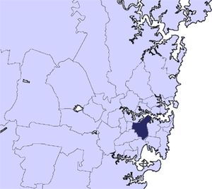
Inner West Council
Local government area in New South Wales, Australia
Distance: Approx. 512 meters
Latitude and longitude: -33.892886,151.15376
Inner West Council is a local government area located in the Inner West region of Sydney in the state of New South Wales, Australia. The council makes up the eastern part of this wider region, and was formed on 12 May 2016 from the merger of the former Ashfield, Leichhardt and Marrickville councils. The council comprises an area of 35 square kilometres (14 sq mi) and as at the 2021 census had an estimated population of 182,818.
Leichhardt Town Hall
Landmark civic building in Leichhardt, suburb of Sydney, Australia
Distance: Approx. 589 meters
Latitude and longitude: -33.8835,151.1574
The Leichhardt Town Hall is a landmark civic building in Leichhardt, a suburb of Sydney, Australia. It stands at 107 Norton Street. It was built in 1888 in the Victorian Italianate style by architects Drake and Walcott.

Petersham Park
Distance: Approx. 588 meters
Latitude and longitude: -33.89166667,151.15
Petersham Park is an urban park located in the Inner West of Sydney, New South Wales, Australia. The park is characterised by well established avenues of Brush Box and Camphor Laurel trees. Facilities in Petersham Park include a cricket oval, a rotunda, a children's playground, and the Fanny Durack Aquatic Centre.
Actors Centre Australia
Distance: Approx. 285 meters
Latitude and longitude: -33.8871622,151.1577
Actors Centre Australia is a private, dramatic arts and acting school offering both certificate and degree level qualifications, based in Leichhardt, an Inner West suburb of Sydney, in New South Wales, Australia.
Weather in this IP's area
broken clouds
13 Celsius
13 Celsius
12 Celsius
14 Celsius
1023 hPa
85 %
1023 hPa
1019 hPa
10000 meters
4.63 m/s
330 degree
75 %
06:20:15
19:04:15